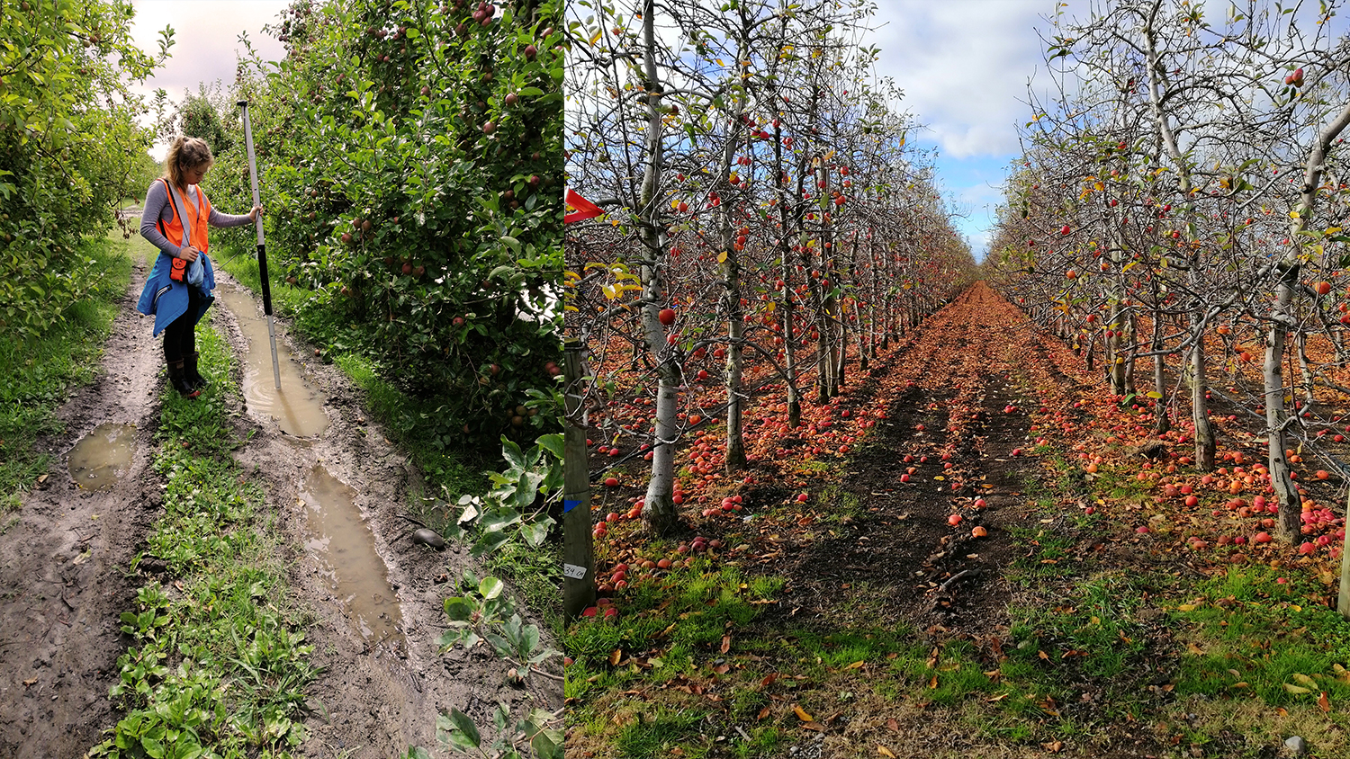
Using the Australian-New Zealand SBAS testbed with an Eos Arrow 100 GNSS receiver, Page Bloomer staff were able to correctly locate items of interest within 350 mm (about 35cm), even in orchards in full leaf. This put them in the right wheel track in the right row, beside the right tree or even half tree. That enabled use of smartphone applications such as Esri Collector and their own rut measuring device and its smartphone application.
The Organization: Page Bloomer Associates
Page Bloomer Associates is a mission-oriented agricultural consultancy in New Zealand. Their team serves the local growing communities by helping farmers to adopt innovative technologies and procedures including precision agriculture to create more sustainable growing practices.
“We sit in the middle between researchers, technologists and farmers,” Page Bloomer Project Coordinator Georgia O’Brien said. “We collaborate to provide growers with solutions when they might not have the resources to run trials themselves.”
The Challenge: Rain, Rain, Go Away!
“A lot of times, places with the worst puddles and ruts coincide with a higher incidence of tree replacements. We don’t always know why a tree was replaced or why it died, but it strongly suggests poor drainage has affected tree health.”
— Georgia O’Brien, Project Coordinator, Page Bloomer Associates

Ponding is water sitting in low spots that cannot drain readily after rain events. As tractors move through the orchard, they create rapidly deepening ruts in the wet, soft soil.
These muddy ruts have risks.
They can reduce work rates and increase the chance of employees rolling their ankles or slipping on muddy picking ladders. Deep ruts make machinery access very difficult, affecting tree management, crop protection and harvest operations — and can contaminate fruit with mud splashes.
“Smart orchard drainage removes the ponding spots by shedding excess surface water quickly,” O’Brien says. “It improves safety and fruit quality. And workers are much happier!”
In new orchards, drainage need not be a problem. The land can be reshaped before trees are planted, achieving a grade that encourages drainage. But reshaping is much harder in existing orchards.

“Once they’ve planted trees, there’s not much they can do. The lifecycle of an orchard is 15 to 20 years.”
— Georgia O’Brien, Project Coordinator, Page Bloomer Associates
“We need the most accurate elevation we can get for the actual leveling,” says Page Bloomer Principal Dan Bloomer. “Because we are moving only centimeters’ depth of soil, we have to use RTK correction with a separate RTK device. But that is an expensive option for all the site monitoring we do, and it doesn’t easily work on smartphones and tablets.”
Bloomer had recently used GNSS receivers with the new Australia-New Zealand SBAS testbed to obtain meter to submeter accuracy in real time under canopy. He was certain the Eos Arrow 100 would provide the location accuracy needed.
“I’d tested the Eos Arrow 100 against smartphone GNSS and other SBAS systems, and I’d seen it had the right level of accuracy for our purposes. Marking ponds and trees we need sub-meter systems. With the Arrow, we could get great results in full-leaf orchards,” Bloomer said.
The First Step: LiDAR Feasibility Study and Orchard Buy-In
“I’d tested the Eos Arrow 100 against smartphone GNSS and other SBAS systems, and I’d seen it had the right level of accuracy for our purposes. Marking ponds and trees we need sub-meter systems. With the Arrow, we could get great results in full-leaf orchards.”
— Dan Bloomer, Principal, Page Bloomer
Three major orchard companies have joined the project so far, offering blocks for trials. Page Bloomer was able to create contour maps and interrow profiles from government-provided LiDAR data. The profiles showed that minimal reshaping should allow water to run freely down rows so ponding would be minimized.
The contour data were entered into OptiSurface drainage-modeling software.
“The LiDAR gave us a good idea of where water was sitting,” Bloomer said. “But we wanted real world checks!”

The Second Step: Field Validation of LiDAR using Esri ArcGIS Collector on Android and Arrow 100 with the Australian-New Zealand SBAS
“With the new Australian-New Zealand SBAS, we’ve been able to get 30-centimeter horizontal accuracy among the trees. Thirty-centimeter accuracy is excellent in an orchard, and it ensures our measurements are correctly located.”
— Georgia O’Brien, Project Coordinator, Page Bloomer Associates

To do this, the modeled findings were field-validated by performing ground surveys in the three blocks. Ponding area locations were recorded after a heavy rain event, and then orchard tree health was observed and recorded. To overcome the poor location performance of their smartphones under trees, the team upgraded their data collection system with an Eos Arrow 100 GNSS receiver.
“We are using the Arrow 100 and smartphone to accurately mark where ponding, ruts, missing trees and replacements are,” O’Brien said. “We can overlay this information on top of the drainage analysis we’ve done.”
The Arrow 100 uses the new Australia-New Zealand SBAS testbed signal to differentially correct its location in real time in the interrow down to levels previously not easily achievable.

“With the new Australian-New Zealand SBAS, we’ve been able to get 30-centimeter horizontal accuracy among the trees,” O’Brien said, “Thirty-centimeter accuracy is excellent in an orchard, and it ensures our measurements are correctly located. We’re in the right row, right wheel track, and by the right tree!”
In addition, the ground-survey matched the drainage modeling.
“We were quite happy to see that,” O’Brien said, “because some of the LiDAR was over ten years old.”
To collect the tree data, they used an Android smartphone running Esri ArcGIS Collector. Collector is a real-time, spatially enabled data-collection app. They configured it to gather information such as per-tree fruit yield, diseased, replaced, or missing trees and the location of ponds and ruts.
“A lot of times, places with the worst puddles and ruts coincide with a higher incidence of tree replacements,” O’Brien said. “We don’t always know why a tree was replaced or why it died, but it strongly suggests poor drainage has affected tree health.”
The Third Step: Reshaping Soil Level, and Testing Other Potential Fixes

With preliminary surveys complete, and evidence showing ponding could be addressed, the team carried out land shaping along rows in the trial orchards. They were guided by an RTK-GNSS, with a separate RTK device, and a WM-Drain program.
“We drove the row and surveyed the profile, and then turned around,” Bloomer said. “The auto-system manages the cut and fill for us.”
The orchardists wanted to test some other approaches in addition to reshaping. This included filling ruts with brought-in soil, cultivating to remove ruts, and ripping to let water escape downwards.


")
With all the test treatments in place, the next step was to track performance. That was going to rely on smartphones …
The Fourth Step: Measuring Rut Depth

To measure the depth of ruts, the team designed a three-leg rig towed by a quad bike. The rig uses a linear transducer to compare wheel track depth to height in the center of the row.
Chris Folkers from Agriculture Software Ltd then developed a wireless data system. The system consisted of two parts:
- First, electronics to capture depth and angles;
- Second, a new iPhone® app called RutRec to record that data.
RutRec receives the depth and angle data via WiFi, and it logs a submeter position from the Eos Arrow 100 with Australian-New Zealand SBAS signal corrections, sent via Bluetooth®. The app stores and exports the precise rutting data for further analysis.
To ensure each treatment is objectively assessed, the team surveyed the ruts of each trial block regularly.


The Results: Encouraging Feedback
“The orchard managers are already happy with the work completed. After an initial amount of rain since the intervention, rows that had not been leveled still had puddles, compared to none for the rows we treated.”
— Georgia O’Brien, Project Coordinator, Page Bloomer Associates
The project, dubbed “Smart Tools to Improve Orchard Drainage”, will take three years in total.
So far, the Page Bloomer team has mapped orchards, trees, ponds and ruts in Esri’s ArcGIS Pro. They have overlaid these and per-tree fruit yields on contour and drainage maps prepared from the LIDAR imagery.
“We think that showing this spatial perspective to growers will allow them to be more aware of how things are happening,” Bloomer said.
Two of the three blocks were reshaped after harvest and before autumn rains, and the other is waiting for the soil to dry enough for leveling.
The goal is not to simply make maps, but rather to use the maps to provide an easy way to understand the relationship between rutting and orchard performance.
“We are seeing many applications for our Eos Arrow and the SBAS system. GNSS is barely used in orchards or by smaller fresh-vegetable growers. Access to tools like the Arrow 100 and inexpensive smartphone apps will guide them to the right tree row or vegetable bed. They can map spray operations and be sure of no misses or overlaps, and they’ll save a huge amount of time marking and finding things of interest, whether that is a patch of weeds, a diseased or dead tree, a broken post or an irrigation hydrant.”
— Dan Bloomer, Principal, Page Bloomer
“It’s still very early, but these technologies have a huge potential to improve the precision of our operations – whether in crops, orchards, or vineyards,” O’Brien said.
Page Bloomer is already receiving more than encouraging feedback as differences are showing up.
“The orchard managers are already happy with the work completed,” O’Brien said. “After an initial amount of rain since the intervention, rows that had not been leveled still had puddles, compared to none for the rows we treated.”
The goal is to provide a proof case so that more growers across New Zealand can adopt the practice, to make orchard operations more fruitful and safer.
“If this method works, local contractors can take our tried-and-true research and do it wide scale,” O’Brien said. “Our role is to show that what can be done. Theirs is to do it.”

2023 Update: SouthPAN SBAS System Now Live for Everyone in the New Zealand / Australia Region
Since the original publishing of this article, the Australia/New Zealand SBAS known as SouthPAN has gone live. To learn more, visit this SouthPAN resource.
Many thanks to the Page Bloomer team for their contributions to this story!
You May Also Like One of These Success Stories
Vineyard Maps 500,000 Vines with Survey-Grade Accuracy
Learn how one premium-wine producing vineyard saved over a half-million dollars by choosing RTK cloud-based mapping over physical barcode IDs.
Australian Organization Surveys Remote Archeology Sites
Hear how one Australian company uses Arrow 100® for heritage management alongside ArcGIS Collector. Originally presented at Ozri 2020.
