Utility saves $2.6M per year by knowing a million asset locations with survey-grade accuracy
The Customer: New Jersey American Water
New Jersey American Water is the state’s largest water and wastewater utility company, serving 2.8 million people in 190 communities in 18 counties. As a subsidiary of American Water, the United States’ largest investor-owned water and wastewater utility, New Jersey American Water provides clean, safe, reliable and affordable service to its customers.
Video Recap:
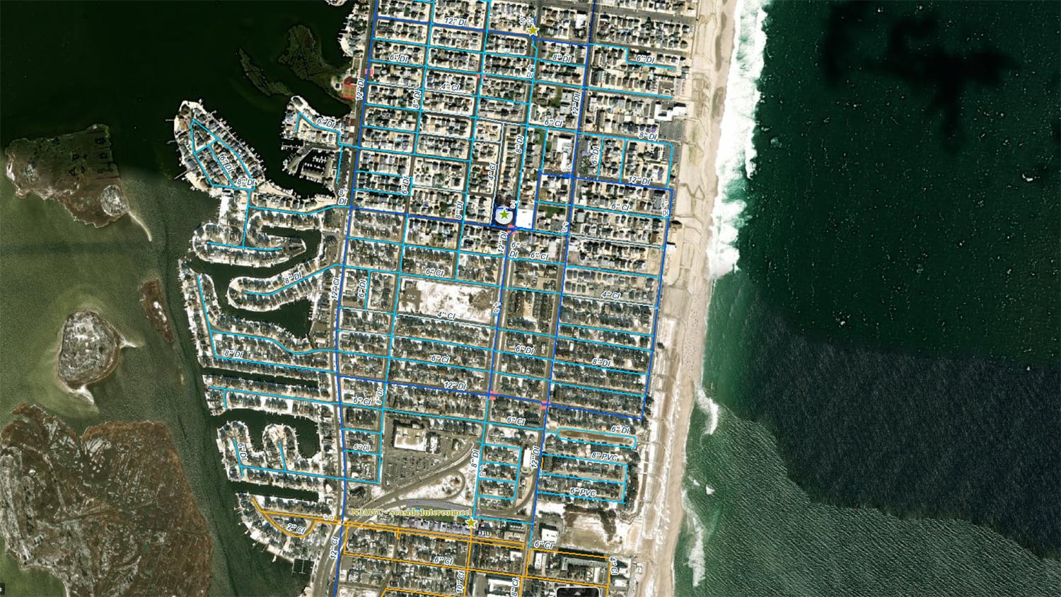
The Challenge: The Perfect Map of Ortley Beach
In the past, New Jersey American Water relied on a variety of data sources to know the location of its water and wastewater assets. Because this data was spread across different platforms and sources, it took a large amount of manual effort to reconcile it within New Jersey American Water’s geographic information system (GIS).
In fall of 2012, Christopher Kahn, Director of UAS and Geospatial Services at American Water, piloted a workflow that would allow field employees to instantly locate all of the utility’s water and wastewater assets throughout New Jersey. He picked the coastal town of Ortley Beach to test a field data collection workflow. Using the utility’s legacy handheld Global Navigation Satellite System (GNSS) devices, he began mapping assets.

But he quickly encountered challenges with the legacy mobile technology.
First, Kahn was faced with manually transferring the data from the legacy GPS receivers to the utility’s GIS. This was time consuming and prone to errors. Files could easily be overwritten, for instance. Moreover, the location data needed to be differentially post-processed back in the office before Kahn officially had decimeter-level locations. He estimates that the legacy technology’s inefficiencies added days of labor to each step of his pilot project.
Still, after all the work was done, Kahn had achieved about 10-centimeter accuracy for all 7,000 assets in Ortley Beach. The date was October 27, 2012, when the first accurate map of Ortley Beach’s water and wastewater assets was completed.
“I met many of the people who lived there year-round,” Kahn recalled. “They helped me find meters under landscaping rocks and so on. Eventually, they helped me finish the perfect map.”
Two days later, Hurricane Sandy made landfall in New Jersey. Ortley Beach would become known nationally not for its perfect map—but for being nearly wiped off the map. Entire neighborhoods were now only sand.

The Inciting Incident: One Took Hours, One Took Days

Hurricane Sandy was, in a word, historic. The storm ripped utilities out of the ground and left an estimated $65 billion in damages.
“Meters were buried, lids were washed away,” Kahn said. “Many of those homes I’d visited were gone. Sometimes all that was left was the actual copper pipe in the sand.”
Kahn had returned to Ortley Beach days after Sandy in order to help locate assets for field staff. Despite the landscape being totally transformed, he was able to locate each meter pit within seconds of looking. Kahn remembers stunning the mobile crews by walking up on a sand dune and announcing that this was the exact location of an asset they were trying to find.


“I came up with my tablet and map and said, ‘It’s right here,’” he recalled. “They had never seen anything like that before. I distinctly remember thinking, ‘It would be amazing if we could do this for all 10,000 miles of New Jersey communities. That would be a game changer.’”
But the other coastal communities without the perfect map did not fare so well.
On the same barrier island, in Mantoloking, there too, everything was gone. Crews spent weeks walking block by block just to locate service lines.
“All of their tap lines and drawings meant nothing,” Kahn said. “Measurements were based on references that weren’t there anymore. They spent hours on each property trying to find assets and do damage assessment. In Ortley Beach, it took a few seconds. In Mantoloking, it could take hours to days to find one service line under the rubble.”
The management at New Jersey American Water quickly saw the value of what Kahn had done at Ortley Beach. They asked him if it was possible to acquire the same level of accuracy for all of the utility’s assets statewide.
Kahn put together an ROI estimate of what survey-grade utility maps could save New Jersey American Water. To cement his research in data, he rode along with work-order crews and observed that each work order took, on average, 12 minutes to locate a buried asset. About 10 of those minutes were spent, on average, searching for and interpreting sketches. Each year, the utility performs about 300,000 work orders that require a person to “get out of a truck and look for something,” such as a shut off valve. So with easy math, Kahn concluded that New Jersey American Water could save over 55,000 hours in the field per year—just by providing access to survey-grade asset maps.
“Never let an extremely challenging experience go to waste,” Kahn said. “We knew we needed to update every GIS asset in our records so each one had survey-grade accuracy. And we could see how the utility and our customers would benefit greatly from this. I wanted to give our crews a laser-guided shovel to every single asset.”
The Solution: A Laser-Guided Shovel
For typical work orders, we know this saves over 55,000 operational expense (OPEX) hours annually.
The legacy GNSS workflow was simply too time-consuming to scale statewide.
“It would take an astronomical cost to scale to a million existing assets,” Kahn said. “We would have had to hire 20 GIS people in the field and office just for the manual pushing around of information, and it would have been slow and expensive. So, I started shopping around.”
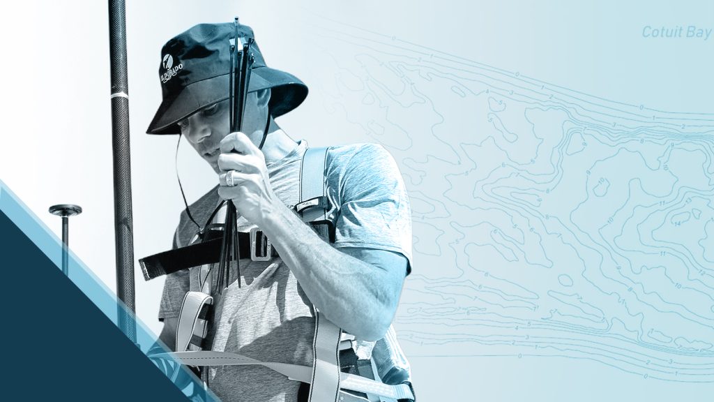
Kahn had heard about a new type of Bluetooth® GNSS receiver that could provide real-time survey-grade positions to any mobile device. Real-time survey-grade positioning would eliminate the need to post-process data back in the office and significantly reduce the occupation time required in the field to map each asset. Additionally, if the GNSS receiver worked with consumer mobile devices, such as a Windows Mobile (popular at the time) or an iPad® (widely used at New Jersey American Water today), Kahn could collect the survey-grade locations using a data-collection app made by Esri. This app had the capability to transfer the updated assets directly to a feature service. This would eliminate even more manual data processing, not to mention the risk of overwriting files.
Kahn ran a pilot test. He selected the Arrow Gold® GNSS receiver from Canadian company Eos Positioning Systems, because of its support for all consumer mobile devices’ operating systems and all Esri data-collection apps.
“At the time, there was mainly one big company that had a stronghold on GPS in the GIS arena,” Kahn recalled. “It seemed like I was one of the few people diving into research about this new type of GPS receiver. I reached out to Eos, and quickly I started interacting with their team. It was really the people I worked with there that made me take the leap of faith in Eos, which at the time was just starting. But whenever I believe in people and they share my vision, I believe in the technology.”
Because New Jersey has no publicly available RTK network to provide free real-time differential corrections to the Arrow Gold® GNSS receivers, Kahn installed his own Arrow Gold® base stations at the utility. The base stations functioned as a source of real-time differential corrections that could be broadcasted to the entire state. Its support for all four GNSS satellite constellations (i.e., GPS, Galileo, GLONASS, and BeiDou) meant that the base station could provide the maximum accuracy and productivity available on the market, when connected to an Arrow Gold® GNSS receiver in the field. This was especially helpful in challenging environments, such as canopy or urban canopy. What’s more, New Jersey American Water owned the base stations, which meant they could provide as many logins as they wished to infinite field workers, without incurring the extra cost per subscription that would be onerous with a subscription RTK network. With the base station setup, Kahn also improved the accuracy of the collected data. It jumped down from decimeter-level with the legacy GNSS devices to sub-inch, with the Arrow Gold®.
This solution, Kahn says, was scalable.
Whereas it had taken Kahn several weeks to collect the initial 7,000 assets in Ortley Beach with the legacy hardware, afterward it was not unusual to see more than 1,000 points collected per day in the most walkable service areas, all with sub-inch accuracy.
Less than two years after Hurricane Sandy struck, New Jersey American Water hired its first full-time employee to collect data in the field. Their task was to capture all of the utility’s buried infrastructure that was visible (e.g., valves, curb stops, meters, hydrants).
“Out of the gate, the data started pouring in,” Kahn said.
The Results: Millions of Dollars Saved Each Year
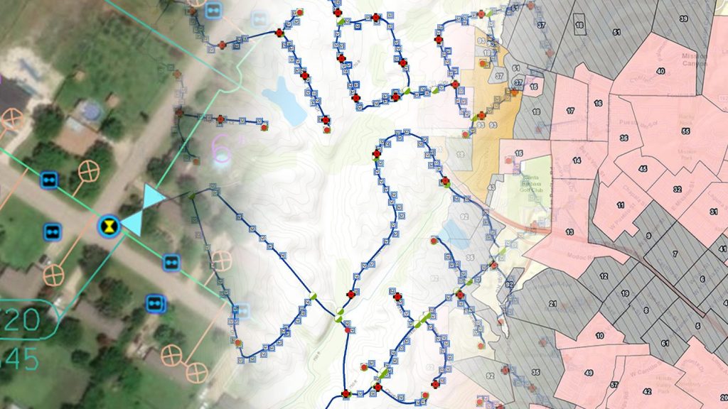
Within five years of starting the state-wide data collection effort, Kahn’s team had successfully mapped all of New Jersey American Water’s water and wastewater assets. The project was completed nearly exactly on schedule. The result was about 1 million legacy utility assets captured across nearly 10,000 miles of service with sub-inch accuracy. Along the way, technicians discovered many assets (e.g., hydrants, valves) that had not previously been recorded in any of the utility’s databases. They also mapped potential hazards, such as missing lids or grading issues, and leaks that needed to be fixed, and alerted maintenance crews who responded with prompt interventions.
Evolving the Workflow, Saving Over $2 Million Each Year

When Kahn started the project, he was using a special customization of an Esri Windows Mobile app. When Collector began supporting RTK, Kahn immediately migrated his team. Today, the utility has migrated to ArcGIS Field Maps, which replaced ArcGIS Collector in 2021.
The mobile devices have also changed. At first, Kahn’s team used Windows Mobile tablets, popular in 2012. But today, the utility has standardized on iOS® devices, choosing this as the most flexible, scalable, and easy-to-use mobile device.
Kahn also used to track the progress of the data being collected in Excel spreadsheets. But almost immediately after Esri released its popular ArcGIS Dashboards, an application that provides spatially stunning summaries of GIS data, Kahn adopted it to facilitate communication with non-GIS stakeholders. For the first time, utility management could visualize, on an interactive map in real time, the progress of assets as they were being captured.
“They wanted a laser-guided shovel that says, ‘Dig here,’” Kahn said. “Today in most areas, we have that. Over time, I knew we would be able to accomplish so much more value for the utility. For New Jersey alone, the ROI spoke for itself.”
Now that legacy assets are accurately mapped, all newly installed assets are now required to be posted to the GIS with sub-inch accuracy.
Just like most details from Kahn’s initial project estimate, the calculated work-order savings is accurate. Today, the utility saves over $2 million each year from efficiencies directly attributed to the survey-grade maps.
To support its GNSS as-built rule, as well as provide all field staff the ability to efficiently navigate back to buried assets, New Jersey American Water has deployed over 150 Arrow Gold® GNSS receivers, to more than just its maintenance crews. More than 30 front-line field service representatives (FSRs) are using a handheld Arrow Gold® configuration for typical day-to-day locates. This “locate” program has been so popular, that the company is currently rolling out an additional 200 handhelds to FSRs. According to Kahn, the feedback has been phenomenal, with crews finally feeling that they have a laser-guided shovel.
“The Arrow units are beginning to become a tool in their truck just like anything else,” Kahn said. “They can walk right up to a service line, without having to infer from the map where it is and without spending time searching and interpreting sketches. For typical work orders, we know this saves about 55,000 operational expense (OPEX) hours annually. However, during emergencies – it is truly priceless.”
Looking Ahead: Collaboration Nation
What happened in New Jersey caught the attention of the American Water parent company.
“The rest of American Water caught on quickly and did it even faster,” Kahn said.
By the end of 2021, American Water had mapped several million assets across its 55,000 linear miles of service area, all with survey-grade accuracy. In states without publicly available free RTK networks (e.g., Virginia, Pennsylvania, Maryland), the company followed Kahn’s example, and has installed Arrow Gold® base stations. Today, American Water owns and operates over 14 Arrow Gold® base stations.
Drones and More
Kahn has since been promoted to Director of Unmanned Aerial Systems & Geospatial Services at the parent company, American Water, where he is actively building an unmanned aircraft system (UAS) program that spans all the regulated operating companies. The drone program is producing extremely accurate basemaps, 3D maps, topography, aerial inspection, water quality, physical security, and even disaster response, that utility staff can use to enhance their GIS work.
The hardware and software he has chosen for the UAS program includes:
- DJI Phantom 4 Pro V2
- DJI Matrice 210
- DJI Matrice 300
- DJI Matrice 600
- Flyability Elios 3
- Wingtra Gen II
- Censys Sentaero BVLOS V2
- Arrow Gold® GNSS receivers, to set ground control points (GCPs)
- Site Scan for ArcGIS, an Esri product that facilitates the capture of drone imagery
- ArcGIS Image Server, for publishing the resultant basemaps to the utility’s GIS maps
- ArcGIS Pro, for Motion Imagery Standards Board (MISB) full motion video (FMV) and for GIS analytics of drone footage

American Water has also created its own “Sky View” application, which allows Kahn to manage the Terabytes of images the utility collects of its elevated assets, such as tanks, critical elevated crossings, and facilities. The application turns heavy data into fast, useful data via several unique features, such as automatically determining the elevation and position of the drone’s perspective on the target asset via exchangeable image file format (EXIF) data stored in the photos. Sky View even applies artificial intelligence (AI) and machine learning (ML) to determine the coating health of certain assets, such as water tanks, automatically by calculating the amount of rust and deteriorating primer.


To date, over 55 American Water employees are Part 107 certified as Remote Pilot in Command (RPIC) from the U.S. Federal Aviation Administration (FAA). Together they have flown more than 600 project locations, covering over 30,000 miles. Kahn expects these numbers to increase rapidly, as most of the piloting has been done by just a handful of the certified staff.
An Eye for AR: Piloting Augmented Reality on a $40 Million Construction Site
Kahn believes that deploying extended reality (ER) and augmented reality (AR) in the field is the next most valuable step for American Water, as it capitalizes on the utility’s successful investments in high-accuracy and high-resolution technologies and training. After reviewing several AR mobile apps, the company has begun a pilot project. The pilot project is being conducted on a large, $40 million construction site in South Jersey. It will provide proof-of-concept for capturing trench infrastructure before burying the conduits and then for being able to view reliably the buried assets on an iPhone®.
“I want to give every employee with an iPhone the ability to see what the buried assets look like in the trench,” Kahn said. “They should be able to walk around, measure, be able to see all the bits and pieces that are not in the asset inventory exactly as if it was uncovered.”
Channeling Lessons Learned into a New Opportunity
I remember people telling me GNSS would be impossible to scale, that we could never find, no less map, every 100-year-old curb stop. But we’ve shown it was possible in New Jersey, and since then, many more utilities have followed.
Kahn is also looking into the possibility of American Water beginning to collaborate with the local electric, gas, telecommunications, stormwater, and other utilities that serve their territories. In New Jersey alone, there are upwards of 16 utilities that own underground assets. Kahn would like to build an information-distribution center, the goal of which is to store all utility assets, of any type, and provide authorized access from a shared information hub.
“Historically, this type of data sharing has been painful,” Kahn said. “But I would like to try. By one estimate, utility strikes pose a $60 billion-per-year problem of damages in North America (yes, billion!). Much of that is due to poor data. It doesn’t have to be this way.”
Kahn says when he first started to collect the data in 2012 at Ortley Beach, not everyone believed he would succeed. Quickly creating, then maintaining, a database of over 1 million assets with sub-inch accuracy was viewed at the time as, if not impossible, “kinda crazy” by his peers. “I remember a few scoffs at the idea that GIS would take on the responsibility for mapping every customer connection,” Kahn said. “Back then, zero customer address points, service lines, meters, and other assets were part of our GIS – we had only the distribution main in the maps, and those were originally from CAD.
“I remember people telling me GNSS would be impossible to scale, that we could never map millions of assets,” Kahn said. “But we’ve shown it was possible in New Jersey, and since then, many more utilities have followed. It’s not a big leap now to see a future in which all assets, of all types, are mapped accurately — and even used in conjunction with AR. I think we’ve sparked imagination in-house and hopefully among other utilities. Because not only is all of this possible — but actually quite doable.”
You May Also Like One of These Posts
Customer Spotlight: Chris Kahn, with Eos from the beginning
Customer Spotlight: Chris Kahn was one of Eos’ earliest customers and has found a sweet spot of efficient CAD, GIS, GNSS, and UAV field work.
5 Water Utilities Using Bluetooth GNSS Receivers
Five water utilities are using high-accuracy Bluetooth® GNSS receivers to transform their mobile data collection. Here’s how.
