Eos Positioning System Annual Recap, 2017
Eleven Things 2017 Taught Us and Our Predictions for 2018
The year 2017 saw vast improvements in high-accuracy GPS/GNSS field data collection. We saw a surge in the use of mobile devices, advanced applications, and GPS/GNSS receivers to create a combined, cost-effective, efficient means of reliable and accurate centimeter location data collection. We also saw the advance of the application technology itself, alongside improvements in satellites available to influence high-accuracy field data collection. In this Eos Positioning System annual recap, we’d like to highlight 11 things we’ve learned the past year in how organizations worldwide are using high-accuracy GPS/GNSS technology to reach their goals and improve our world.
# 11 — Mapping 10,000 Miles of Assets is Possible with a Smartphone, Receiver and App
Original Article: U.K. Water Utility Maps 10,000 Miles of Assets with Sub-Meter Accuracy (Sept., 2017)
Northumbrian Water in England needed better confidence in its wastewater asset locations. With just iPad®s, the Esri ArcGIS Collector app, and the Arrow 100, Northumbrian Water quickly and accurately mapped more than 10,000 miles of water pipeline. This allowed the utility to share more accurate asset data to maintenance crews’ dependent on reliable location data to respond quickly to service requests and maintenance issues.
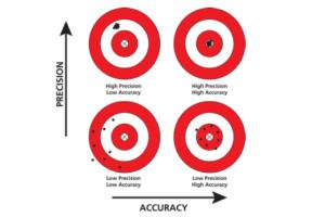 #10 — High Accuracy is Different from High Precision
Original Article: UAVs and GNSS | Using High-Accuracy GNSS to Set Ground Control Points (GCPs) for UAVs (June, 2017)
What is the difference between precision and accuracy? In short, precision measures the repeatability of your data collection. Accuracy measures the variation between your data collection and its real-world position.
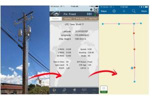
#9 — As-Builting Doesn’t Have to be Painfully Time-Consuming
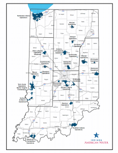
Original Article: Indiana American Water Slashes Half-Year Workflow to One Week (Nov., 2017)
Indiana American Water contributes services to one of the largest publicly traded service areas in the United States. Using legacy technologies, Indiana AmWater was able to turn around as-builts in approximately six months — optimistically. After switching to Arrow, iOS®, and ArcGIS Online, the utility cut as-builting to just one week. You can learn the details of their journey here.
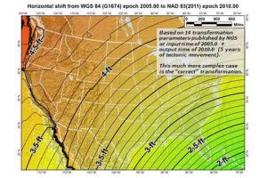 # 8 — Why Doesn’t My GPS Data Line up with My GIS?
Original Article: Why Doesn’t My GPS Data Line up with My GIS? (May, 2017)
You’ve done your due diligence. You’ve taken data from the field with the latest technology, but when you bring your data into the GIS, it’s all off by several feet. What went wrong? In this article, Eos explains how to make your technology work for you. Collect data in the field and make it line up with data in your GIS.
#7 — You Can Collect 600 Assets Per Day with Arrow
Original Article: Arizona Co-Op Collects 600 Assets Per Day with Centimeter Accuracy GNSS and New Release of Collector (Aug., 2017)
After an internal request for more accurate asset data, the GIS team at Sulphur Springs Valley Electric Cooperative (SSVEC), launched an audit of a complete substation — or approximately 8,000 assets’ worth — of data. The project required quick, accurate field-data collection across rugged Arizona terrain. Using Arrow, Collector, and iPad technology, SSVEC was able to reliably collect up to 600 points per day.
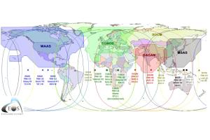
#6 — Five Free Satellite-Based Augmentation Systems (SBAs) For Submeter Corrections
Original Article: Exploring the Five Satellite-Based Augmentation Systems that Can Give You Submeter Corrections for Free (Jan., 2017)
Satellite-based augmentation systems (SBAS) offer free, quick, accurate submeter location-data corrections. In this article, Eos’ own Alvaro answers the question, “Why do some GNSS receivers using SBAS achieve submeter accuracy, but others don’t?”
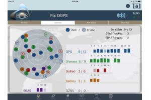 # 5 — Four Constellations Available Today For Sub-meter GNSS Mapping
Original Article: Four Constellations for Sub-Meter GNSS Mapping (March, 2017)
How do satellite constellations contribute to high-accuracy GPS / GNSS mapping? And just which satellite constellations are in orbit today to help organizations using GPS / GNSS receivers? Eos offers a comprehensive and visual overview and analysis of the four constellations available worldwide and how you can exploit them in your current technology. See the constellations here.
# 4 — Can You Create Your Own RTK Base Station?
Original Article: Setting up Your Own RTK Base Station (Feb., 2017)
And in the first place, why would you want to? In this article, Eos staff explain why setting up your own RTK base station could save you thousands of dollars in annual user fees. In addition, you’ll learn how to create your own RTK network by taking advantage of the location accuracy of GPS / GNSS receivers like Arrow, so you can avoid costly, per-user annual fees associated with accessing RTK networks.
 # 3 — Two Reasons Your Mobile Device Lies About GNSS Accuracy
Original Article: Is Your Mobile Device Lying to You About GNSS Accuracy? (April 2017)
This is one of the most common questions we get at Eos: “Why is my mobile device mis-representing my receiver’s accuracy. The glitch lies in a miscommunication between the device itself and the receiver’s actual accuracy. In this article, Eos explains how to derive the true accuracy of any GNSS receiver you use.
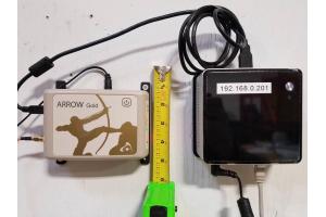
 # 2 — Three Improvements Coming to Arrow Receivers
Original Article: The Esri 2017 International User Conference – A Perfect Technology Storm (July 2017)
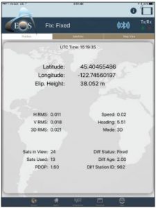
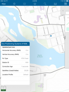
High-accuracy GPS / GNSS data collection is great, but only if it saves you money on multiple projects, in the long run. That’s why Eos has been innovating. In the last half of 2017 and beyond, Eos is creating three improvements to the Arrow product suite you love. First, we’re supporting long-range RTK connection. With Enhanced RTK algorithms, we bring you centimeter-level mapping. Second, the Eos Tools Pro app for iOS and Android now supports a datum shift within Arrow, so you can use any app for built-in location conversions. Finally, Eos Arrow receivers now support enhanced RTK statuses, so you can access performance data about your corrections, signal, and other RTK statuses.
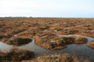
A pool system, which is typical of an intact raised bog[/caption]
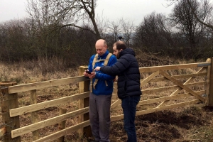
# 1 — Monitor Ireland’s Last 1% of Peatlands with GPS / GNSS
Original Article: Irish Surveyor Monitors Europe’s Last Remaining Peatlands (Oct., 2017)
When nearly all of Europe’s bog has declined from forestry and agriculture, how do you monitor the last remaining one percent? With a smartphone, Esri’s ArcGIS Collector, and the Arrow 100, one small-scale Irish surveying organization has been able to lobby for greater preservation of the world’s last remaining peatlands. See how Wetland Surveys Ireland did it.
Looking Ahead to 2018:
Eos looks ahead to 2018 with excitement and passion for the advancements about to be made available to our customers.
With each new Galileo and BeiDou launch, the Arrow 100, Arrow 200, and Arrow Gold receivers’ performance will improve without any action required by the user once the new satellites are declared healthy. Just this month (December 2017), four more Galileo satellites were successfully launched from the French Guiana Spaceport. In 2018, expect more Galileo and BeiDou satellites to be launched as Europe and China build out their constellations. The GPS and Glonass systems are in maintenance mode with no new net increase in their respective constellations expected in 2018. That illustrates the value of support for all four constellations.
Great news for Africa, South America, and Australia/New Zealand users. Until now, obtaining sub-meter GNSS accuracy in Africa, South America and the Australia/New Zealand market required expensive GNSS receivers and expensive subscription services. That’s changing!
In 2018, Arrow 100 users will have the ability to use a worldwide high-performance, accurate satellite subscription service in Africa and South America for real-time 50cm GNSS accuracy.
In Australia/New Zealand, SBAS corrections are available today (since June 2017) from its SBAS test bed. We’ve tested the Arrow receivers using this free service and it performs beautifully, delivering 60cm real-time accuracy or better.
Eos Latest News from the Eos December 2017 Issue
- News: New Galileo quartet successfully launched on Dec 12, 2017. This will soon bring the Galileo constellation to 19 usable satellites. (Source European GSA). “EVENT DESCRIPTION: GALILEO SATELLITES GSAT0215 (SVID 21), GSAT0216 (SVID 25), GSAT0217 (SVID 27) AND GSAT0218 (SVID 31) WERE LAUNCHED ON 2017-12-12 AT 18:36 UTC. GSAT0215, GSAT0216, GSAT0217 AND GSAT0218 ARE PLANNED TO BE POSITIONED IN SLOTS A03, A07, A04 AND A01 OF THE CONSTELLATION. USERS WILL BE ADVISED OF AVAILABILITY OF SIGNALS FOLLOWING COMPLETION OF COMMISSIONING ACTIVITIES.”
- News: MN DOT to upgrade RTK Network to support Galileo. Scheduled network maintenance on January 3rd, 2018.
- Eos Tools Pro: New version (v1.66) for iOS released on App Store.
- GNSS Satellite Launch: Here is a chart of Upcoming GNSS Satellite Launches (byProf. Richard Langley).
- SBAS News: Australasia SBAS Test-bed has been broadcasting test corrections on PRN 122 since June 2017.
Al’s Corner – Technical Tips
 Hi… My name is Alvaro and I am the Technical Support Manager at Eos Positioning Systems. I am inviting you to visit our Learning Center on our web site for useful technical information, how-to’s and video tutorials. This section will be updated regularly with new material. Any question? please do not hesitate to contact our technical support center.
– New version of Eos Tools Pro for iOS is available on the App Store. Version 1.66 now features saveable NTrip profiles, enhanced interface for datum shift/offset, automatic re-connection to RTK stream after loss of Internet connectivity. New Android version will also be available soon.
– Here is an interesting one-hour recorded Esri Water webinar on How to get started withArcGIS Collector. Get tips from Jeff Shaner, Senior Product Manager at Esri, on how to create web maps, download the popular Collector app, viewing results, and more.
How-To
Enabling Mock Location on Android for Eos Tools Pro
This “how-to” document shows how to setup Mock Location on your Android device for Eos Tools Pro.
Video Tutorial

Upcoming Events
- January 29-31. Esri Water Conference 2018, San Diego, CA, USA. Visit us at booth #9.