600 Assets Per Day with Centimeter Accuracy GNSS, Thanks to Arrow Gold GNSS
![]() Situated in the high desert of southeastern Arizona, Sulphur Springs Valley Electric Cooperative (SSVEC) serves power to a remote and varied landscape. SSVEC’s service area is about the size of Connecticut and includes everything from unforgiving mountains to grasslands.
Situated in the high desert of southeastern Arizona, Sulphur Springs Valley Electric Cooperative (SSVEC) serves power to a remote and varied landscape. SSVEC’s service area is about the size of Connecticut and includes everything from unforgiving mountains to grasslands.
In early 2017, SSVEC received an internal request to improve the data accuracy regarding a small portion of its system along this terrain. The GIS team calculated that to meet the internal request, they would have to perform a field-data-collection project to reconcile more than 8,000 asset records associated with this substation.
month.
The Need for Speed
One of the project requirements was to be up and running in a very short period. SSVEC GIS Supervisor Kurt Towler was given just three weeks to launch the entire project, from data modeling and database setup to user training, technology acquisition, and everything in between.
Towler began looking for a solution that not only met his need for speed, but also could reliably deliver the comprehensive data improvements his internal stakeholders needed.
Towler had a few givens about what the solution would look like. He knew it would be mobile. He needed to put a field crew in the mountains and grasslands of Arizona and needed them to reliably, quickly, and accurately gather all the data required to reconcile the asset records.
“That meant the technology would have to work wherever our field crews were,” Towler said.
Towler also wanted a mobile solution that felt familiar, meaning it aligned with today’s consumer expectations of an easy-to-use app.
“In one day, my field crew had to be completely comfortable using the technology,” Towler said.
Towler turned to Esri’s ArcGIS Collector.
“There are a lot of apps out there,” Towler said. “We picked Collector mainly because of its configurability and ease of use with ArcGIS Online.”
On the backend, Towler moved his data out of production and created a duplicate geodatabase. Then he removed the geometric network and simplified the database to streamline field collection and bulk editing. Finally, he published his data to ArcGIS Online and began configuring Collector.
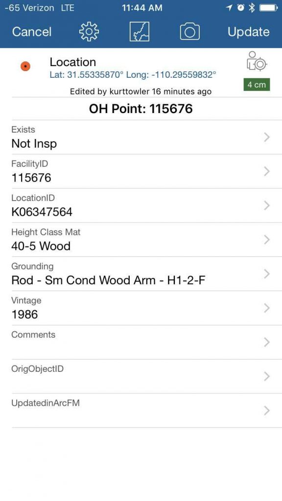
Towler created drop-down forms and, because he realized his team might encounter up to 87 possible asset combinations at each location, he created a one-to-many data model published to ArcGIS Online. In a very short time they configured their reference geodatabase, ArcGIS Online and Collector to collect all of their high accuracy GPS data.
The other reason Towler selected Collector was because it didn’t require intensive training. Towler could put two electrical linemen in the field, despite having no training in spatial technology, and take advantage of their proficient knowledge of electrical infrastructure.
“With Collector, I could enable others to use GIS technology who didn’t have years of training,” Towler said. “I literally didn’t have the time to train anyone in electrical infrastructure or GIS. When a lineman looks at a power pole, they see all the information of the details we needed. They are the experts.”
Towler’s next challenge was figuring out how to override his mobile devices’ native GPS data, which wasn’t accurate enough for this project.
Staying on Target Thanks to Arrow Gold and a New Collector Release
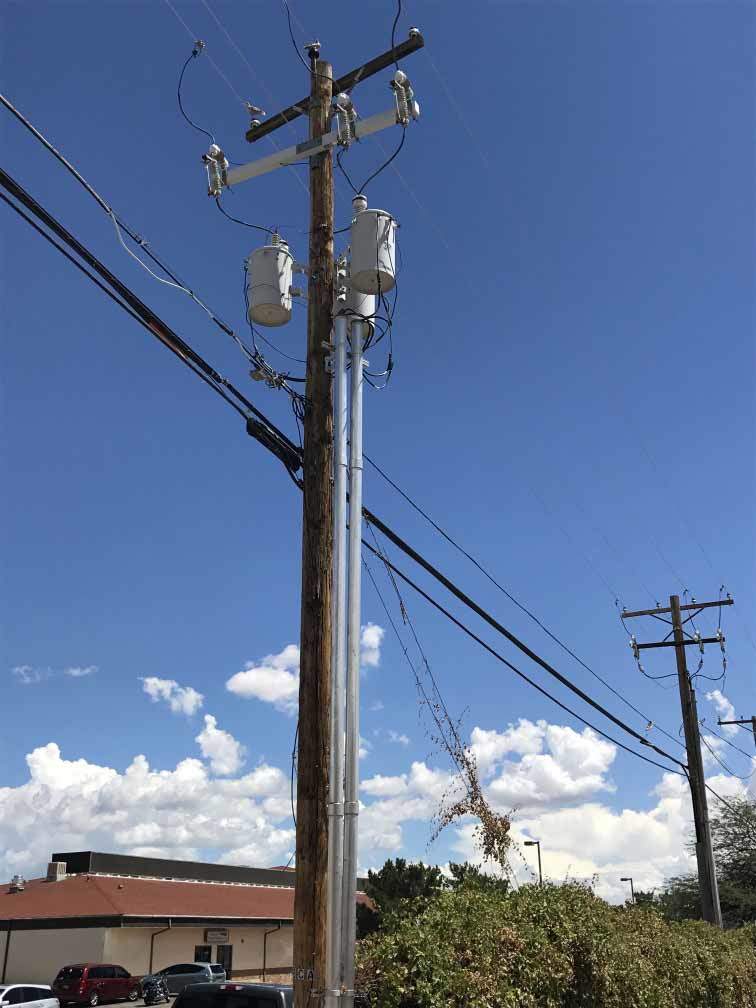
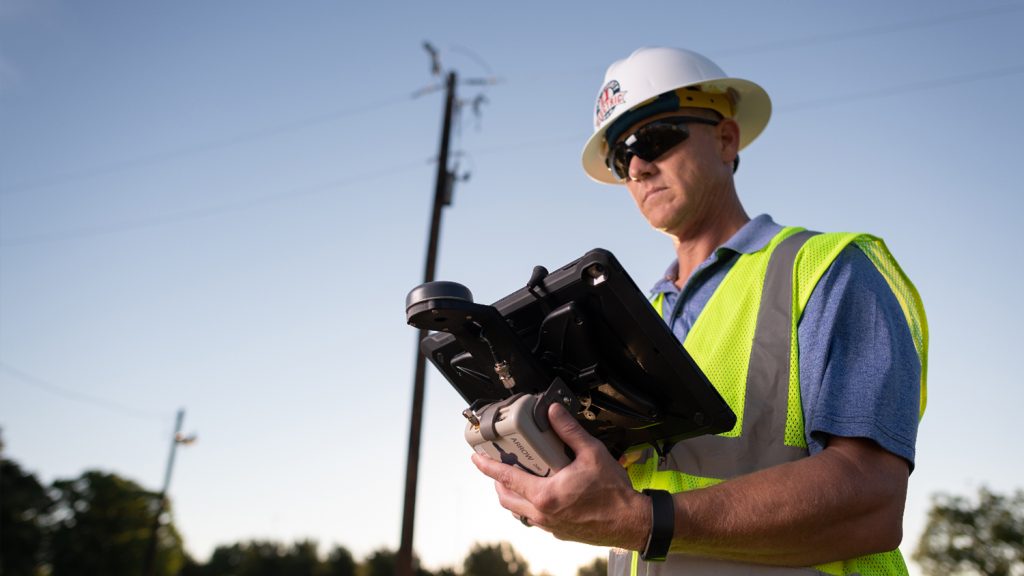
Towler’s linemen would work on two iPad Mini® 4s. The iPads were lightweight, had hand straps for easy carriage, and could be used all day thanks to portable chargers. However, on their own, the iPads’ native GPS could be up to 300 feet off, whereas Towler’s project required centimeter accuracy.
“Assisted-GPS on mobile devices is not reliable enough,” he said.
Meanwhile, most mobile GIS apps including Collector did not automatically record any advanced location metadata of their own.
“Without this metadata, it was impossible to tell which locations were right or wrong,” Towler said. “Many of our facilities were not in the right spots, so you didn’t know what data to trust.”
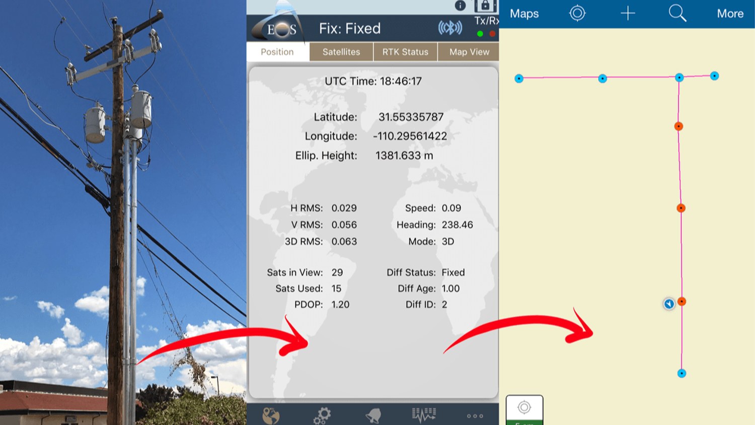
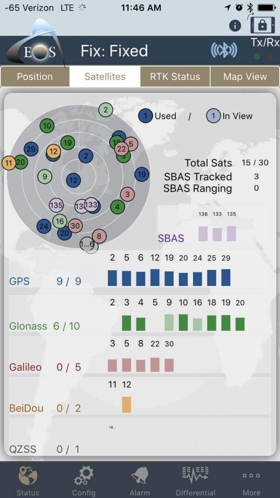
There were GNSS receivers, though, that could tap into high-accuracy metadata, such as estimated accuracies, position fix types, the total number of satellites used, a differential station ID, and more. And thanks to a 2016 update to Collector, the Esri app now pulls this advanced metadata directly from an external GNSS receiver via Bluetooth, without any manual effort.
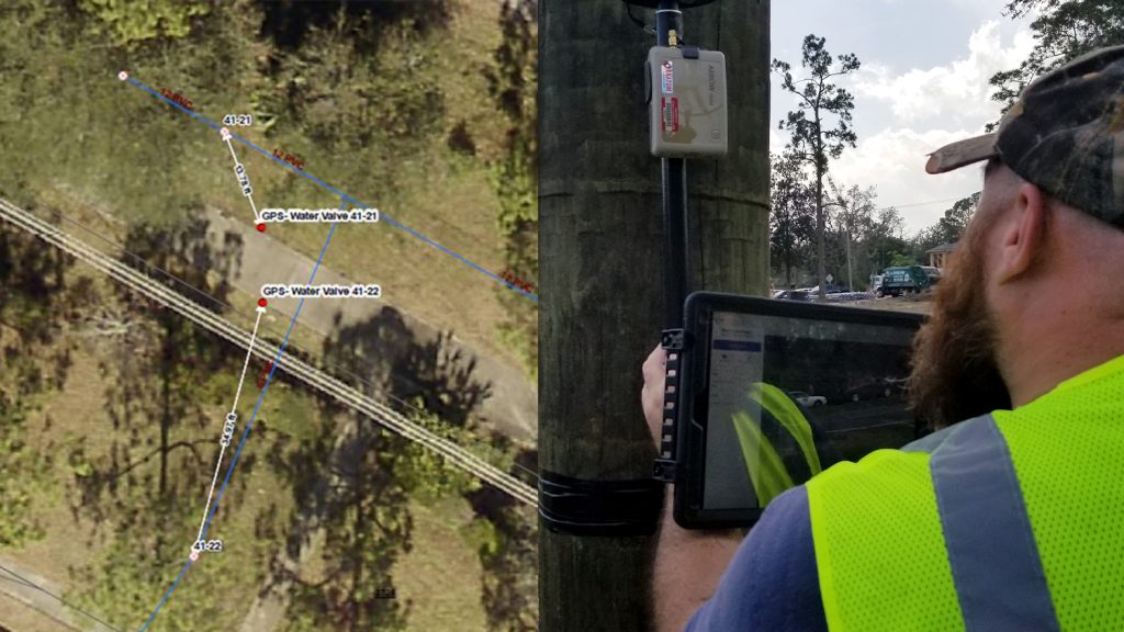
After doing a little research, Towler selected the Arrow Gold GNSS receiver, manufactured by Canadian Esri Partner Eos Positioning Systems.
“The Arrow Gold receiver was very easy to hold, very lightweight,” Towler said. “I was impressed with how far the technology has come. The whole thing can be carried on a belt.”
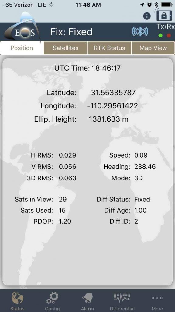
The Arrow Gold would tap directly into the State of Arizona’s free, Real-Time Kinematic (RTK) satellite navigation network to capture advanced location metadata. The Arrow Gold then relayed this metadata to the iPad via Bluetooth connection. On the iPad, the Eos Tool Pro app received the Arrow Gold’s metadata and sent this automatically into Collector, which overrode the less accurate iOS® location and gave SSVEC centimeter asset metadata.
In addition, since RTK corrections were being used in this case, Collector had the added the ability to set a location profile so that Towler could establish an on-the-fly datum transformation to ensure they retained data accuracy. By doing this for each point, SSVEC could achieve location accuracy to within centimeters. All in all, setting up the data transfer from the Arrow Gold to Collector on the iPad took less than an hour.
“It was remarkable,” Towler said. “Truly remarkable. It’s almost self-configuring. We played around and had some fun, and at most it was a couple hours to feel that the technology works so well. It cut our spin-up time dramatically.”
Testing the Technology: 600 Points Per Day in the Field
Towler trained his linemen in Collector and the iPad apps, and then set them loose.
“I gave them a half day of training,” he said. “We put this into the hands of someone who does construction for a living and leveraged their skillsets instantly. It gives you confidence you can get moving.”
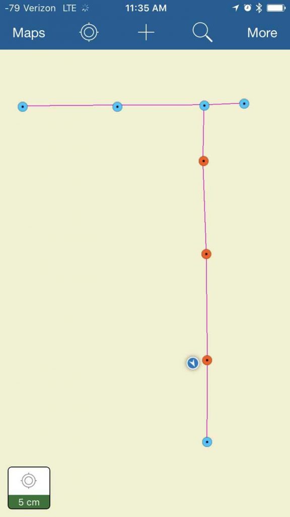
Towler estimated the linemen could afford to spend about three minutes per location to meet their deadline, which left little time for technology failure or glitches. In just over a month, Towler had his answer. In 32 days, his two linemen had collected 34,000 asset records at 7,640 facilities. They averaged 235 locations per day but regularly beat the average.
per day with 2-centimeter accuracy
while using the Eos Arrow Gold,
ArcGIS Collector, and iPad.
“The first few days were really about training, before we found our rhythm,” Towler said. “There were many days when the linemen were getting an unbelievable amount of work done. In the middle, they were collecting 600 points per day.”
The median accuracy was 4.6 centimeters, but the linemen regularly beat this, too.
“Most of the time they got into the 2-centimeter range,” Towler said. “That’s nearly perfect for us. Without this RTK network, you couldn’t really guarantee better than twelve feet.”
A Use Case for the Cloud
SSVEC significantly improved the accuracy of its 8,000 facilities, and Towler says the asset reconciliation project has completely changed the way his organization understands its asset inventory.
“Many assets moved 50-100 feet,” Towler said. “That’s a big difference, when you look at a road and want to know on which side of the road the pole is located.”
Towler says the productivity, scalability, and reliability of Collector and cloud technology has been proven. Today’s GIS, GNSS, and related technologies are far more valuable and far less expensive than ever before.
“We built an entire GIS program with the explicit idea that our decision-makers should have accurate and reliable information to run a power company,” he said. “In this project we proved that we can deliver.”
To watch a one-hour recorded webinar Towler presented to Esri Electric and Gas User Group Meetup, click here. Also, be on the lookout for Towler’s new podcast series launching this fall: “Speaking of GIS.” Speaking of GIS is a discussion of GIS and the people that make it happen.
This story was originally published in Esri ArcNews. Read the original story here.
Download a PDF of this article in ENGLISH.
You May Also Like One of These Success Stories
Texas Co-op Improves Customer Service with Futura and Arrow
Real-time access to enterprise ArcGIS via Futura & FieldPro helped TCEC achieve 4-hour as-builting. They used Arrow Gold for field staking GNSS locations.
Florida Utility Creates First Digital Twin of Electric Assets
NSBU on the Florida coast needed a real-time, easy-to-use high-accuracy data collection system to replace paper redlining.
