Are you ready to learn how to get free GPS sub-meter corrections with SBAS satellite systems? Here’s your guide to the five SBAS and how to use them for free corrections
SBAS (Satellite-Based Augmentation System) around the world provide free, real-time sub-meter corrections for high-performance GNSS receivers. SBAS is a fantastic, free public service that GIS professionals around the world can use to make their GNSS receivers more accurate, and therefore make their GIS databases more accurate.
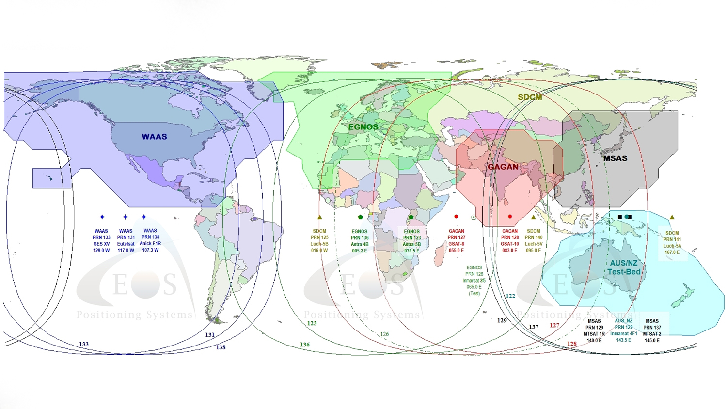
The beauty of SBAS is that each covers an entire continent. For example, the WAAS SBAS in North America covers Canada, the United States, Central America as well as the northern portion of South America. That means your GNSS receiver can receive sub-meter corrections anywhere on the continent, without requiring internet connectivity.
All SBAS are operated by government agencies and designed primarily for aviation navigation. This means that SBAS are extremely reliable. They never go “out of service” for any reason. Following is a list of current SBAS around the world:
WAAS (Wide Area Augmentation System) – Canada, United States, Central America, northern region of South America.
EGNOS (European Geostationary Navigation Overlay Service) – Western/Eastern Europe and Northern Africa.
MSAS (Multi-functional Satellite Augmentation System) – Japan.
GAGAN (GPS Aided Geo Augmented Navigation) – India and parts of surrounding countries.
SDCM (“System for Differential Correction and Monitoring”) – Russia (in deployment)
Due to the success of public SBAS, more countries are deploying or considering deploying their own SBAS.
In October 2016, it was announced that South Korea were partnering with Thales (Thales helped develop EGNOS) to deploy KASS (Korean Augmentation Satellite System) by the year 2021.
In January 2017, it was announced that Australia plans to invest $12M over a two year period to test SBAS technology.
All SBAS GNSS corrections are computed from a network of ground monitoring stations and sent to the user via geosynchronous satellites using the same frequency as GPS. Nearly every GNSS receiver manufactured today is “SBAS-enabled” so they are automatically configured to receive and use SBAS corrections. No extra hardware (receivers or antennas), nor proximity to one of the ground monitoring stations are required. All that is needed is that the receiver tracks at least one of the SBAS satellites and be within the broadcast ionospheric correction area of the constellation.
All GNSS receivers don’t handle SBAS the same
SBAS corrections being sent from the SBAS satellite are the same for every receiver. Then why are some receivers capable of sub-meter accuracy using SBAS and others only achieve 5-meter accuracy if the receiver is using the same SBAS correction?
The difference is how the receiver utilizes the SBAS corrections. Professional GNSS receivers like our Arrow GNSS Series are designed to squeeze the maximum accuracy from SBAS corrections. For example, with the typical implementation of SBAS, a GNSS receiver emphasizes integrity over accuracy. Aviation requires a super-high level of integrity called “five nines”, which is 99.999% confidence. In non-aviation applications, 95% confidence is the industry norm. In that case, a GNSS receiver optimized for non-aviation SBAS trades integrity for improved accuracy. That, and other tricks, is what allow high-performance GNSS receivers like the Arrow to achieve 60cm accuracy with 95% confidence using SBAS corrections.
To test the accuracy performance of a GNSS receiver using SBAS corrections, you need access to a survey mark with published ITRF08 coordinates. All SBAS are referenced to the ITRF08 frame. In the United States, one can find a survey mark on the ground using the NGS Data Explorer. Go occupy a survey mark with your GNSS receiver that’s using SBAS corrections and you can measure how it is performing.
Our Arrow GNSS receivers are optimized to extract the highest accuracy possible from all of the worlds’ SBAS. That’s the reason their stated accuracy is 60cm at 95% confidence. The Arrow also employs a patented technology that allows it to continue using SBAS in impaired GPS conditions such as under trees and around buildings. To enhance positioning in impaired conditions, the Arrow receivers can actually use the SBAS communications satellites like GNSS satellites for position measurement (except for EGNOS which does not support ranging).
So, if sub-meter accuracy is what you are interested in, take a look at SBAS and talk to us about our Arrow receivers.
Explore Related Knowledge Base Items
RTK: Want Centimeter Accuracy on Your iPad® with Arrow GNSS?
In this article we show you how to get high-accuracy locations, including submeter and cm data, with your Arrow GNSS receivers on any iPad or iPhone.

SafeRTK®: How to Stay Productive When RTK Coverage is Inconsistent
This article shows you how to handle unstable connections / spotty coverage by understanding correction age while collecting RTK data.