How to know if your mobile device GNSS accuracy is correct — or if your device is lying to you?
It’s really cool when your mapping app displays the estimated accuracy of the GNSS receiver you are using. Conversely, there’s nothing more frustrating than your mapping app showing a GNSS estimated accuracy that is wrong . Unfortunately, the latter is quite common. The problem is that you likely don’t know that your mapping app is giving you bogus GNSS accuracy values. In this article, we’ll show you how to know if your mobile device GNSS accuracy is correct.
There are two reasons why your mapping app (eg. Esri ArcGIS Collector) will give you the wrong estimated GNSS accuracy:
-
Your iOS® or Android device is not reading data directly from the GNSS receiver. Yes, it’s “faking” it. iOS is a major culprit of this method. You can have a 1cm RTK GNSS receiver connected to it via Bluetooth, and iOS will still report 5 meter or 10 meter accuracy from its location service. Not 5.2 meters, not 1.2cm, but just 5 meters or 10 meters or other random integer. Apple likely did this because the accuracy of the GNSS receiver in your iPad®/iPhone® is pretty bad. Sure, sometimes it’s good, but even a broken clock is correct twice a day. Accuracy needs to be repeatable in order for you to count on it.
The ONLY way for your iOS or Android mapping app to report a reasonable estimate of accuracy is if it reads the data directly from the GNSS receiver. The software must be purposefully built to read estimated accuracy data directly from the GNSS receiver. Unfortunately, most mapping apps haven’t taken the time to incorporate this functionality. Esri incorporated it into Collector about one year ago, along with GNSS metadata recording and so did other mobile app providers like TerraGo, AmigoCloud, CMT, SST Software, Taxus-IT, etc.
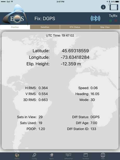
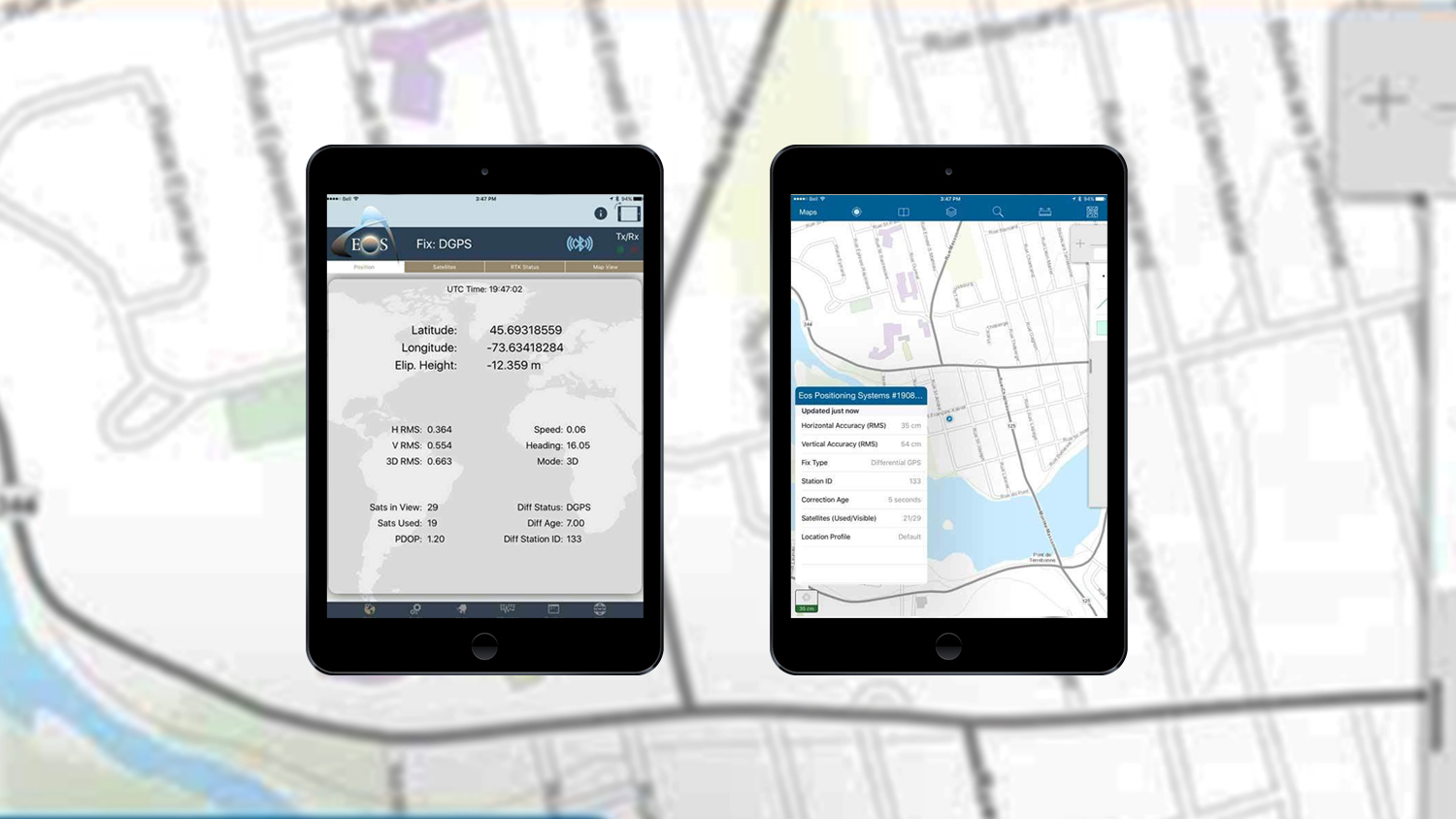
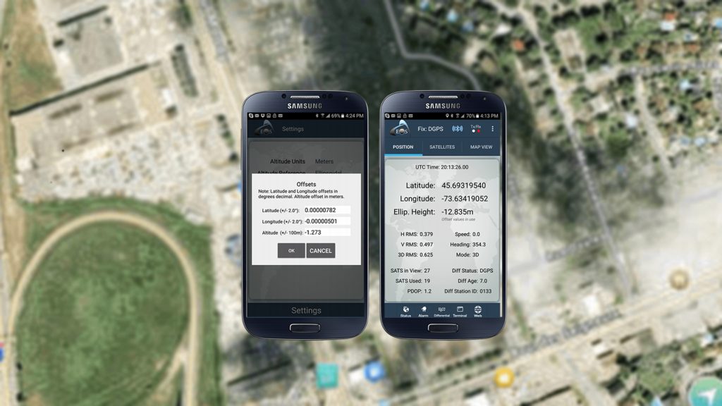
Estimated Accuracies on Eos Tools Pro (Arrow 100 using WAAS)
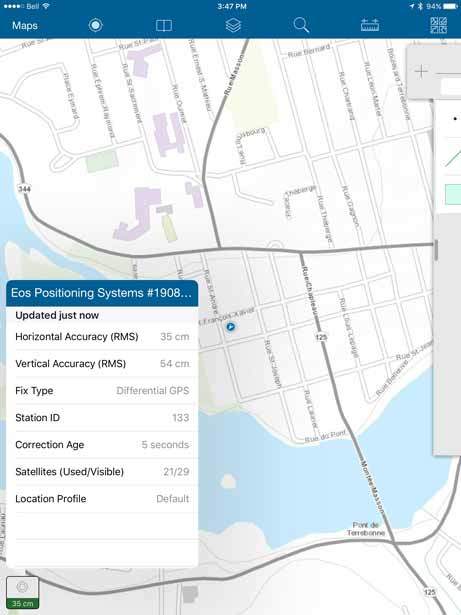
Estimated accuracies and GNSS metadata in Esri’s Collector (Arrow 100 using WAAS)
Without the estimated GNSS accuracy being displayed on the screen in your mapping app, you are “flying blind”. However, all is not lost. You can run our Eos Tools Pro software in iOS or Android in conjunction with your mapping app and it will allow you to set an alarm so it warns you if you attempt to collect data that doesn’t meet certain accuracy requirements. It’s not as an efficient solution, but you can get the job done.
iOS isn’t the only culprit in this scenario. Android offends in the same manner. Windows doesn’t report an estimated accuracy at all.
-
The other problem with estimated GNSS accuracy is that some GNSS receivers are very optimistic with their estimated accuracy values. For example, we’ve seen a Youtube video of a high-precision receiver reporting an estimated accuracy of 60cm while inside of an office building! Well, you and everyone else know that isn’t true. How do you determine if a GNSS receiver is reporting a reasonable estimated accuracy? The only way to accomplish this is to occupy a survey mark (one whose coordinate has been accurately determined) and compare the results of the GNSS receiver to the coordinate of the survey mark. Using this method, you’ll understand two key data:
-How accurate your GNSS receiver is (whether it’s inside your mobile device or Bluetoothed to your mobile device).
-How close the estimated accuracy value is to the real accuracy of the GNSS receiver.
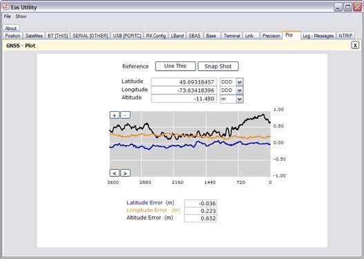
Actual (true) accuracy in Eos Utility over a 1 hour period (Arrow 100 using WAAS)
But that’s not all…
If you really want to fully understand the GNSS receiver’s performance, you must test the GNSS receivers in the environment you’ll be working in. This can be difficult because nearly all GNSS survey marks are located in places that have a wide-open view of the sky. If you work under and around trees, buildings or in rugged terrain, GNSS receivers behave differently in those environments as opposed to clear sky. In impaired environments, GNSS receivers are usually less accurate. The question is how much less accurate AND how accurate is the estimated accuracy output by the GNSS receiver in those environments. From some of our comparative testing, we’ve seen that some high-accuracy GNSS receivers (not ours of course) fall apart under tree canopy and high-multipath environment and still report optimistic estimated accuracies but actually deliver quite a bit lower accuracy. Unless you do some testing in your environment, you’ll never know if the estimated accuracy displayed on your mobile device is close to the truth. Another simple method would be to go back to previously recorded points and check the consistency and repeatability of your receiver in these environments.
When we design or improve the firmware in our receivers, an important step is that we test the Arrow on survey markers with a known coordinate. We test them in the clear sky, we test them under light, medium and heavy tree canopy, and we test them near buildings. It’s not a small effort to do thorough testing like this, then adjust the firmware, then test again. However, if we don’t go through this pain, we can’t tell you what kind of performance you can expect in different environments, and neither can other GNSS receivers.
Explore Related Knowledge Base Items
Elevation for Beginners: What to Know About GPS Receiver Elevation
What is the difference between the ellipsoid, mean sea level, geoid, geoid height, and orthometric height? Here’s everything to know about elevation.
Eos Tools Pro: How to Compute Datum Offset Values
Knowing how to compute datum offsets is important for shifting between datums. The Eos Tools Pro app now supports computing datum shifts. Here’s how to use it.