In part one of this series — “What is GPS and GNSS Positioning? A GPS Overview” — we established that the basis of all GNSS positioning math is the time of arrival of satellite signals. In fact, time of arrival is the mathematical foundation for all GNSS positioning technology — whether it is in your phone, in your vehicle, or part of a survey-grade system. So why, if all GNSS technology relies on the same math, do various GNSS receivers provide various levels of accuracy and precision?
The short answer is that not all GNSS technology is created equal. Of course, you already know that your GNSS receiver’s make and model dictates which combinations of constellations, frequencies, channels, and differential correction sources it supports. But this last point is critical: Why are differential correction sources needed in the first place? The key word is “correction.” Just what are we correcting — and why?
“What are we correcting — and why?”
As we alluded to in part one of this series, there is always some type of error (often more than one) introduced when calculating a GNSS position. In this part two of this series, we will identify the four biggest sources of GNSS error. This sets the stage for us understanding how various GNSS hardware addresses, or sometimes ignores, sources of GNSS error.
It is important to keep one thing in mind as we explore GNSS errors. That is that there are two main categorizations of error: First, there is the type of error that we can avoid, or mitigate, before or while we collect data. And second, there are errors that we can’t avoid (such as the error from the ionosphere, which we’ll discuss in the next section). When we can’t avoid a source of error, we must (or should) correct it during or after the fact. Ultimately, one of the greatest influences in the accuracy you will get in the field is how your GNSS equipment helps you avoid, mitigate, and/or correct GNSS errors. It’s important to note that we’ll be providing a high-level conceptualization of these topics in this article; each of the concepts covered can be discussed in much more granular detail at higher levels of study.
For our purposes, let’s get started …
On This Page: Table of Contents
The biggest source of GNSS error is the ionosphere
Do you remember from part one how many kilometers above the Earth’s surface all GNSS satellites orbit? Spoiler alert: It is about 20,000 kilometers. That means each GNSS signal travels roughly 20,000 kilometers from its satellite to your antenna. And just like most things in our world, these signals don’t travel through a vacuum.
Soon after a signal leaves its satellite, it exits the vacuum of space and enters Earth’s atmosphere. You might think this is a small detail, but the atmosphere is actually an enormous part of our GNSS story. The atmosphere is made up of incredibly small, physical particles. These invisible yet tangible particles affect not only the rockets and meteors sailing through them, but also GNSS signals. In fact, one segment of this atmospheric journey is the most important detail we will talk about in this series: The ionosphere.
Did you know?
The troposphere is also a source of GNSS error. But GNSS error from tropospheric activity is far less than that from ionospheric activity.
What is the “Ionospheric Highway”?
While not a distinctive layer of the atmosphere itself, like the stratosphere or mesosphere, the ionosphere is actually a “series of regions in parts of the mesosphere and thermosphere where high-energy radiation from the [s]un has knocked electrons loose from their parent atoms and molecules,” according to the University Corporation for Atmospheric Research. Because the sun has knocked loose so many electrons, the ionosphere is a bumpy stretch of direct-to-Earth highway for GNSS satellite signals.
Essentially, a ride that would otherwise be smooth in a vacuum becomes bumpy, scattered, and delayed — by nanoseconds to microseconds — along what we will call the “Ionospheric Highway.” A nanosecond might seem insignificant to us on Earth, but even a few nanoseconds of delay in time of arrival can cause many meters of error in GNSS positioning math.
Have you ever listened to AM radio?
If so, you probably already observed the effect the sun has on signal transmission. In the daytime, you can often hear more interference on AM radio. But after nightfall, the sound cleans up. This is because the ionosphere is quieter during night time, and this has a significant effect on the propagation of signals both above and below its layers.
Why would a rocky ride create a GNSS math nightmare? Recall that time of arrival is the basis of all GNSS math. Moreover, this math is based on nearly impeccable atomic clocks. So when a signal gets knocked around on its path toward Earth, every nanosecond of delay generates a measurable error in the calculations of X, Y, Z, and t. When you consider that every single satellite signal of the 20, 30, or even 40 satellites your GNSS receiver is tracking has been scattered here and there along the Ionospheric Highway, it’s easy to see how the initial mathematical result can yield many meters of error. This is one of the reasons why a consumer GPS receiver, which typically does not correct for ionospheric activity, is usually far less accurate than a professional-grade GNSS receiver. To be fair, consumers usually don’t need to correct ionospheric activity. A few meters of inaccuracy here or there will probably not prevent most of us from navigating to a new store, following a popular hiking trail, and so on. In professional use cases, however, a few meters of inaccuracy can mean the difference between striking a gas pipeline or not, spending an extra ten minutes or more on each work order, and creating other undesirable inefficiencies and inconveniences.
Does weather play a role in GNSS error?
Many people think weather, such as clouds or rain, is a source of GNSS error. In reality, weather is an insignificant source of error. At most, weather could be responsible for only a millimeter-level of GNSS error.
As you might have guessed, there is no fast track that allows satellite signals to avoid the Ionospheric Highway. For this reason, ionospheric influence is an inevitable source of GNSS error. The only way to address this error is to accept that it exists — and correct it. In part three of this series, we’ll discuss the ways various GNSS hardware corrects for ionospheric activity.
For now, however, we have three more sources of GNSS error to discover …
Key takeaways
- Rather than travel through a vacuum, GNSS signals travel to Earth along the bumpy Ionospheric Highway.
- The Ionospheric Highway causes signals to have an imperfect time of arrival, which yields imperfect positioning results.
- The ionosphere is the biggest source of error in GNSS math.
- Unfortunately, it is also unavoidable.
The second biggest source of GNSS error is multipath (signal reflection)
Now that we’ve established the vast impact a mere nanosecond of delay can have on our accuracy, we’re ready to explore the second biggest source of GNSS error: signal reflection. Among GNSS veterans, signal reflection is also commonly referred to as “multipath,” because of the multiple paths a signal can take before reaching your receiver’s antenna.
What is multipath?
Simply put, multipath is when a signal takes anything other than a direct path from satellite to antenna. In other words, the signal bounces off physical objects, such as a tree, a building, glass windows, or even a body of water, before reaching your antenna. These multiple paths introduce errors in the computation of the distance between the antenna and the satellite. As a result, it causes your accuracy to drop. Multipath is a key culprit behind reduced accuracy under canopy, in urban environments, and on boats. Yet unlike ionospheric activity, in a few situations, multipath can be mitigated — and sometimes avoided — through choices you make in the field.
How to avoid or mitigate multipath
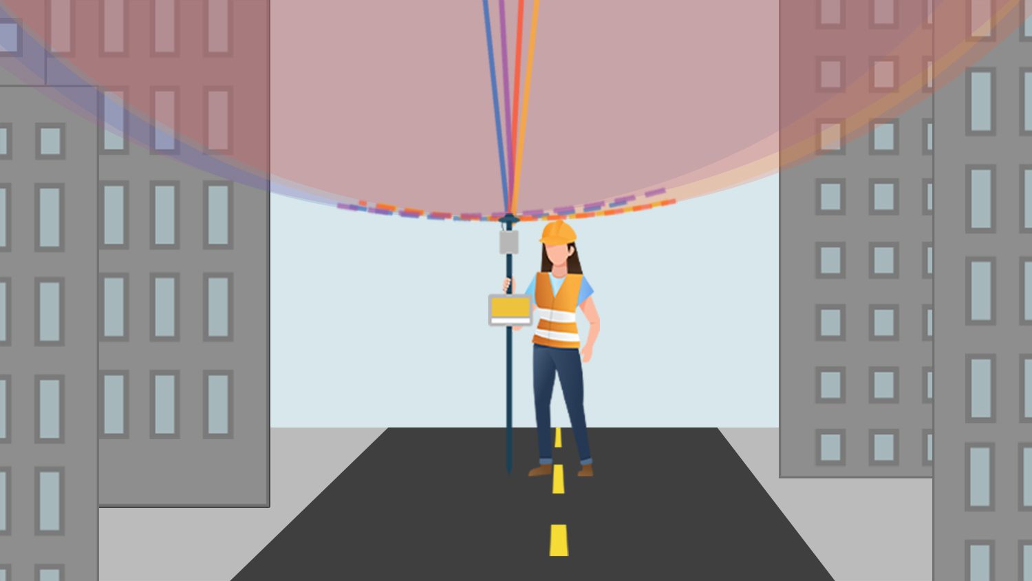
There are several possible ways to reduce the impact of multipath. Your first line of defense against multipath is always to ensure your GNSS gear is mounted properly to avoid signal reflection we could anticipate. Did you know, for example, that your body is the most immediate object that could obstruct the direct path of signals to your antenna? So making sure your antenna is mounted above your head is key.
Where should you place your GNSS antenna?
Placing your antenna on the ground will increase your chances of multipath. For this reason, we recommend never using a GNSS antenna on the ground. If possible, elevate the antenna above your head. Even a couple of feet above ground level will improve your accuracy.
Next, look around you for environmental obstructions. Trees and buildings are common culprits. Thankfully, these days there are so many high-quality satellite signals to pick from, that if you find yourself surrounded by light canopy or mild infrastructure, you can often have plenty of strong signals to rely on. However, in very dense canopy or city centers, you might need to change your field data-collection setup. In these environments, a laser-offset solution, such as Eos Laser Mapping™ for ArcGIS, might be your best bet. Capturing locations with a laser allows you to stand far away in a spot with clear line-of-sight to the sky, so you can collect data without significantly compromising positioning integrity.
Does water reflect GNSS signals?
Just as water reflects sunlight, it reflects GNSS signals. This can lead to higher instances of multipath for people near or on bodies of water.
In addition to these in-situ choices you make, sometimes your hardware itself can act to mitigate the impact of multipath. This is part of a process called “signal processing.” Eos GNSS receivers, for instance, use proprietary intelligence to identify which signals are probably being reflected. They then treat these signals as having less integrity than pure-path signals when calculating a position. In addition to this, the quality of your GNSS antenna can play a great role in multipath rejection. While these aren’t a cure-all for multipath, this combination of real-time signal processing and antenna quality is one of the reasons you might get higher accuracy with an Eos GNSS receiver than others in the exact same environment.
One last consideration for multipath is your horizon. Just as UV rays are weakest at sunrise and sunset, when the sun is low on the horizon, GNSS signals become weaker as they orbit lower on your horizon (where they are at a lower angle, and are therefore likely to experience more refraction and reflection). Generally speaking, this means it’s good practice to filter out signals from satellites low on the horizon. Eos GNSS receivers are factory-configured to reject satellites below a certain elevation angle, to ensure signals of only sufficient strength are being used.
Thinking about where satellites are on the horizon is a good segue into our third source of GNSS error. So now that we understand multipath is the second source of error, let’s move on to number three …
Key takeaways
- Multipath describes signal reflection — creating alteration and delays — which in turn impact your positioning accuracy.
- You can greatly reduce multipath through choices you make, such as how well you mount your antenna to provide the clearest possible view of the sky.
- Some GNSS receivers, including all from Eos, engage in “signal processing” to identify signals of low integrity and remove these from their calculations.
The third-biggest source of GNSS error is poor satellite geometry, expressed in a DOP value
If you’ve spent time inside the Eos Tools Pro app, you might have seen the letters “DOP.” DOP stands for “dilution of precision.” In the simplest terms, DOP is a measurement of the quality of the geometric spread of your GNSS satellites. In other words: How spread out are the satellites you’re tracking? (Hint: We would like them to be well spread across the sky.) Let’s look at why this could be important. …
In part one of this series, we discovered that GNSS antennas need to track at least four satellites in order to calculate a 3D position. What we didn’t discuss was the precision of this calculation (i.e., how repeatable it is). Your precision depends on not just the total number of satellites — but also their geometry in the sky.
Why would the satellites’ geometric spread impact precision?
Imagine you are standing in an empty field. There are no trees, no structures, no lakes, and your GNSS antenna is mounted above your head. It’s almost the ideal GNSS environment. For the sake of this exercise, you are tracking exactly four satellites, and they are well spread-out above you, high above the horizon. Now let’s draw some imaginary lines to connect you and your satellites. First, draw a circle around each satellite. Make sure the satellite is at the center of the circle. Also, make sure your circle intersects your antenna. When you are done, you will have four imaginary circles, all of which intersect at your antenna as a point. This idea of intersecting as a point is the important detail to notice. Because your circles are so widely spread out, it is very easy for you to distinguish the exact pinpoint at which the circles intersect at your antenna. Unsurprisingly, it is also very easy for your equipment to distinguish this point. This is our key takeaway: When your satellites are extremely well spread-out, the location of your antenna is clearly and neatly defined. We can repeat the process over and over, and as long as your satellites remain well-spread, it’s very easy to pinpoint your antenna. This is called precision. In this example, our precision is about as undiluted as is possible.

Now imagine you’re in a city. Tall skyscrapers rise above you on either side. With all these obstructions, the only satellites your antenna can pick up are the ones directly above you, in a tiny strip of clear sky. Once again, you’re tracking four satellites. Let’s repeat the exercise from before. Draw a circle that contains each satellite as its center. Make each circle intersect with your antenna. Do you notice anything different? This time, the four circles intersect not at an easily identifiable point, but rather at overlapping arcs. Imagine these arcs overlapping at your antenna. If you had to pinpoint the exact location where these arcs intersect, you will have a hard time. This is the task of your GNSS equipment: trying to pinpoint where these satellite signals intersect in order to generate an accurate antenna location. Just as you struggle to find the exact intersection of these arcs, so too will your hardware. We would say in this example that your precision — which again, is the repeatability of your positioning — has been diluted due to poor satellite geometry. It’s not an environment we would like to capture data in, if we can avoid it. This is why dilution of precision, or DOP, is our third biggest source of GNSS error.

Can you mitigate DOP?
There are some steps you can take to improve your DOP and make sure you use only accurate locations in the field. This starts with making sure that your antenna’s view of the sky is not obstructed. Of course, sometimes this is not possible. So a second step you can take in a difficult field environment is to monitor your DOP. Most professional GNSS receivers will output a DOP measurement you can monitor for this reason. (By contrast, most smartphones and consumer GPS devices do not output DOP values, because most consumers are not looking for such high precision when doing civilian activities.) The DOP number you will read in a GNSS monitoring application is a unit-less value. A low DOP (below 1 or 2) is considered ideal, whereas a high DOP (such as 7 or 8) is considered poor. A DOP can never be zero.
If you see that your DOP is high, you can choose to wait for the satellites to shift in their orbit. This is a bet that their geometry will improve, even if your environment cannot. You could also use an app like Eos Tools Pro to set an alarm for a DOP threshold. This would alert you not to collect data when your DOP rises above a certain number you set, such as 3. In Eos Tools Pro, you can find your DOP — which is updated every second — in the “Position” page of the app’s “Status” menu.
When is it important to monitor DOP?
In the early days of GPS, when there were fewer satellites, it was always important to monitor your DOP and to wait for the best possible geometric spread. Nowadays, because there are so many GNSS satellites available, we recommend monitoring your DOP primarily when your satellite number is greatly reduced, which could be the case in a forest, deep canyon, or city with tall buildings.
What if I cannot improve my DOP?
Sometimes, forests are too thick and cities are too developed to offer a good line-of-sight to the entire sky. In these cases, we recommend a solution like Eos Laser Mapping. By configuring your GNSS equipment with a laser, you can stand in a better GNSS environment and capture your assets from afar. Eos Laser Mapping was specifically developed for this purpose.

DOP could be its own article …
Although we’ve introduced the concept of DOP, it can actually get even more detailed than what we’ve discussed. For instance, there’s an HDOP value, which measures the horizontal component of error caused by DOP from NDOP and EDOP (northing and easting) components. There’s a VDOP value to measure the vertical component of error caused by DOP. And there’s a PDOP value, which measures the combined positioning DOP, based on HDOP and VDOP. There’s even more with GDOP involving time (TDOP)! Most of our customers can be successful with just a high-level understanding of DOP.
Key takeaways
- When your satellites are more geometrically spread out, your precision improves.
- By contrast, when your satellites are not well-spread, your precision has been diluted; this is known as dilution of precision, or DOP. The higher your DOP value, the poorer the quality of your satellite geometry.
- Professional GNSS receivers output a DOP so you can make smarter choices about when to collect data. This is especially important in forests and cities with tall buildings.
- DOP cannot be corrected. But it could be avoided by waiting for a better set of satellites to collect data or by using solutions like Eos Laser Mapping.
The last major source of GNSS error comes from drift
Previously, we learned that each GNSS satellite follows a fixed orbital plane. We also learned each one has on board nearly impeccable atomic clocks. Would it surprise you to learn that both this precise orbital plane and these extraordinary clocks can experience drift, which influences our computations? Let’s look at each one separately …
Orbital Drift
Over time, a satellite can drift out of its projected orbital plane. The drift is usually not much. But as you might imagine, even a slight orbital drift can lead to many meters of error in positioning. To correct this drift physically, each satellite is equipped with booster rockets. Skilled operators can use these boosters to shift a satellite back into its desired orbit. However, it’s not feasible to use these boosters all the time, as they would run out of fuel. For this reason, most governing bodies choose to monitor the drift and correct it more frequently with math, rather than fuel. Using ground monitoring stations around the Earth, each governing body monitors the integrity of its GNSS satellites drift. These observations about orbital integrity are known as “ephemeris.” Keep this in mind while we explore one other type of drift …
Atomic Clock Drift
The last type of drift we’ll discuss comes from the atomic clocks. Recall that an atomic clock is estimated to experience roughly one second of drift over 30,000 years. Although very small, this drift still (of course) causes errors to our calculations.
Thankfully, the solution for both types of drift is straightforward.
Monitoring and Correcting Both Drifts
Ground stations around the world monitor and compute both clock and ephemeris drifts. In turn, the GNSS satellites receive these computations as data, which they then broadcast to the GNSS users in a specific message. So as each GNSS satellite transmits positioning information, it is also transmitting information that your receiver can use to correct both types of drift.
Pretty neat, eh?
Key takeaways
- GNSS satellites experience two types of drift: orbital drift (space) and atomic-clock drift (time). Both impact positioning.
- Both types of drift are monitored by a network of ground stations and subsequently broadcast to GNSS satellites, which in turn transmits this information to receivers.
- It is possible to have positioning errors if the drift data have not yet been transmitted to the satellites from the monitoring stations.
Summary of GNSS error
In this article we explored the four main sources of GNSS error:
- The Ionospheric Highway
- Multipath (signal reflection)
- Dilution of precision (DOP, or poor satellite geometry)
- Drifts in space (orbital drifts) and time (atomic clock drift)
With exception for the ionospheric and drift-based errors, we also covered how you can avoid or mitigate some of these sources of error.
In the next article, we will discuss the many ways we can correct for ionospheric disturbance. But before this, here is a summary of the available cures of the above sources of errors:
- Ionosphere: Can be almost completely corrected.
- Multipath: Cannot not be corrected but can be mitigated, reduced, or avoided.
To do this, mount your GNSS antenna properly with a clear view of the sky. Choose solutions like Eos Laser Mapping in the worst conditions. - Dilution of precision (DOP): Cannot be corrected but can be monitored to avoid collecting poor-quality points in the field.
To do this, mount your GNSS antenna properly with a clear view of the sky. Wait for a better satellite spread. Choose solutions like Eos Laser Mapping in the worst conditions. - Clock and ephemeris drifts: Can be corrected (or compensated for) almost completely.
The effect of these drifts on the accuracy is very minimal compared to the other sources of errors and, for the sake of simplicity, we will assume that these errors will be compensated while correcting for the ionospheric errors in the next section.
Let’s continue onward to part three: “How Do GNSS Receivers Correct Error?” Check back in fall of 2023 for part 3 of this series. Or subscribe to our newsletter to be emailed automatically when it is released.