In July 2023, Esri User Conference (Esri UC) attendees joined Eos Positioning Systems for our annual “What’s New in High-Accuracy GPS/GNSS for GIS Users” hosted lunch. Product and industry leaders from three companies, including Eos and Esri, provided rich overviews on the exciting updates for ArcGIS Field Maps., Eos GNSS receivers and solutions, and the GNSS industry at large. In this content-packed session, the following topics are covered: ArcGIS Field Maps updates and roadmap; Eos and Esri support for Windows 11; mobile device management (MDM) capabilities in Field Maps and Eos Tools Pro; new data-collection settings for high-accuracy; introduction and overview of the brand-new Galileo High Accuracy Service (HAS) (i.e., free 20-cm or better accuracy worldwide using the Arrow Gold+™ GNSS receiver); initial Galileo HAS test results/observations from around the world; and more.
To get started, watch the session recording below, or scroll through the transcript to find a specific topic.
Watch the 2023 Esri UC Session Recording: “What’s New In High-Accuracy GPS/GNSS for GIS Users?”
Read the Session Transcript:
Introduction
SARAH ALBAN: Hi, welcome, everybody. Thank you for making time for this session during your lunch hour. My name is Sarah Alban. I’m the Director of Marketing at Eos Positioning Systems. We see a lot of familiar faces, but if you’re not yet familiar with us, we’ll get to know a little bit more about what we do in this session.
We have three awesome speakers sharing the stage today. First, we are going to have Jeff Shaner. Jeff is the senior product lead for mobile apps and at Esri. He’s got over 28 years of experience building software products, and he will talk about the latest developments in ArcGIS Field Maps. Next, we have Eric Gakstatter. Eric is the principal GNSS consultant at Discovery Management Group (DMG). Eric has worked in high-accuracy GNS for over 30 years. He’s going to talk today about what’s new in the world of GNSS, with an emphasis on practicality in the field and GNSS signal updates. Finally, we’ve got Jean-Yves Lauture. Jean-Yves is the founder and CTO of Eos. Jean-Yves is actually credited with creating the world’s first Bluetooth GNSS receiver that can provide one-centimeter-level accuracy to any mobile device, including iOS®. Jean-Yves is going to talk today about what’s new from Eos Positioning Systems, including some hardware and software updates. So with that, I will give the floor to Jeff.
ArcGIS Field Maps Overview
JEFF SHANER [Esri]: Thank you, Sarah. So, Sarah said that I’ve been with Esri for 28 years. I’ll just preface that also with I’m only 35 years old now. Sorry to be a child genius. But I want to talk to you today briefly about what’s new in ArcGIS Field Maps. I’ll spend a bit of time on its capabilities and then I will hand it over to these guys. How many people here are using ArcGIS Field Maps today? Wow. Like everybody. Okay, so I don’t really need to explain too much. I’m done. Thank you. [audience laughter}
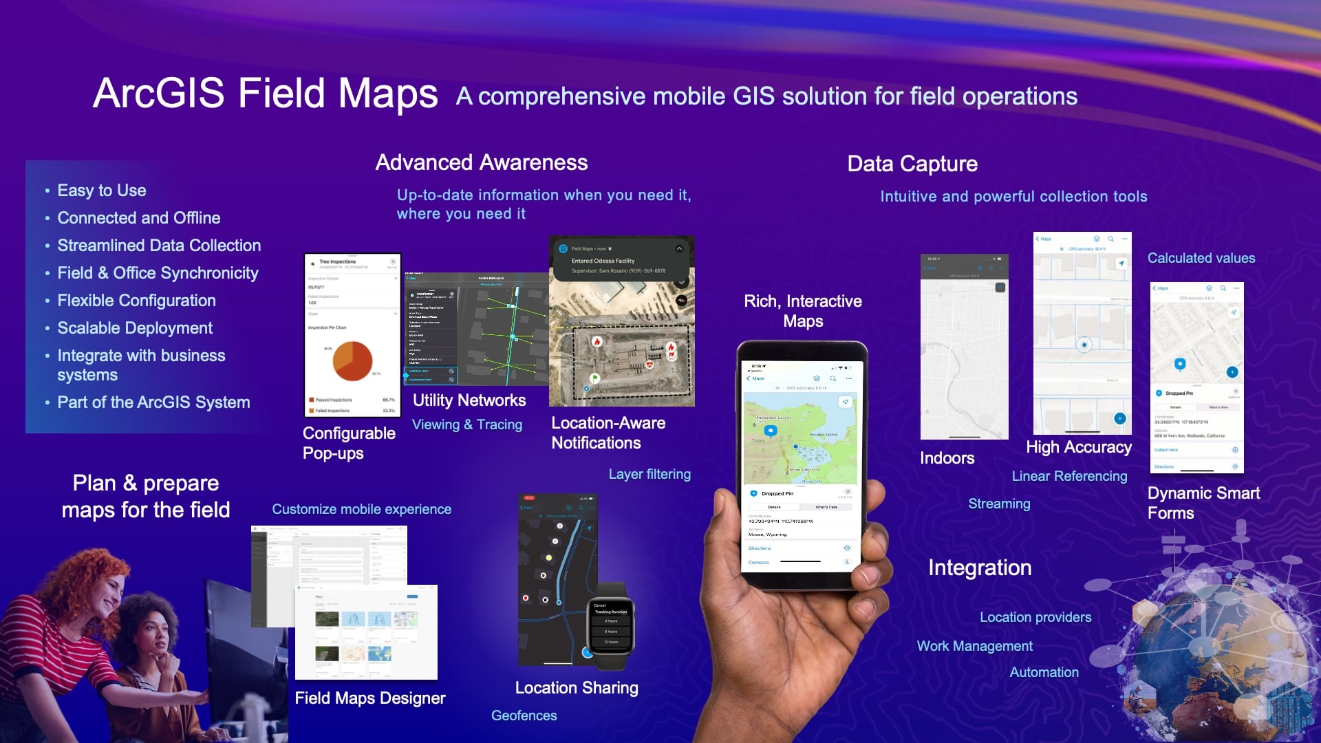
One of the key things about ArcGIS Field Maps that I’ll mention is that we don’t just look at it as data capture. Sorry about that Jean-Yves. I know that’s really important stuff, but it’s more of a comprehensive system. So we’ve been pulling together capabilities of multiple products to build Field Maps. We look at it as your primary application for imagery to enhance awareness or, you know, understanding your data in the context of where you are able to have your data talk to you using concepts like referencing where you are, being able to support the recording and sharing of your location — to also enhance situational awareness. And we’ve got a lot of exciting new things coming out early next year that I’ll talk to.
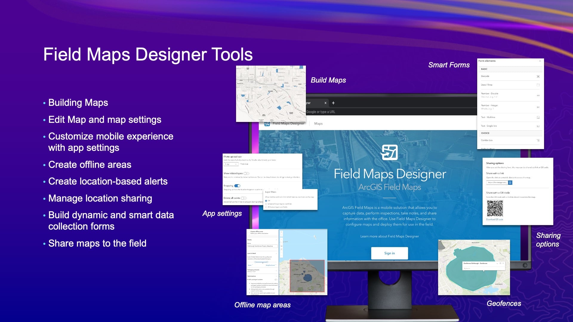
Field Maps Designer
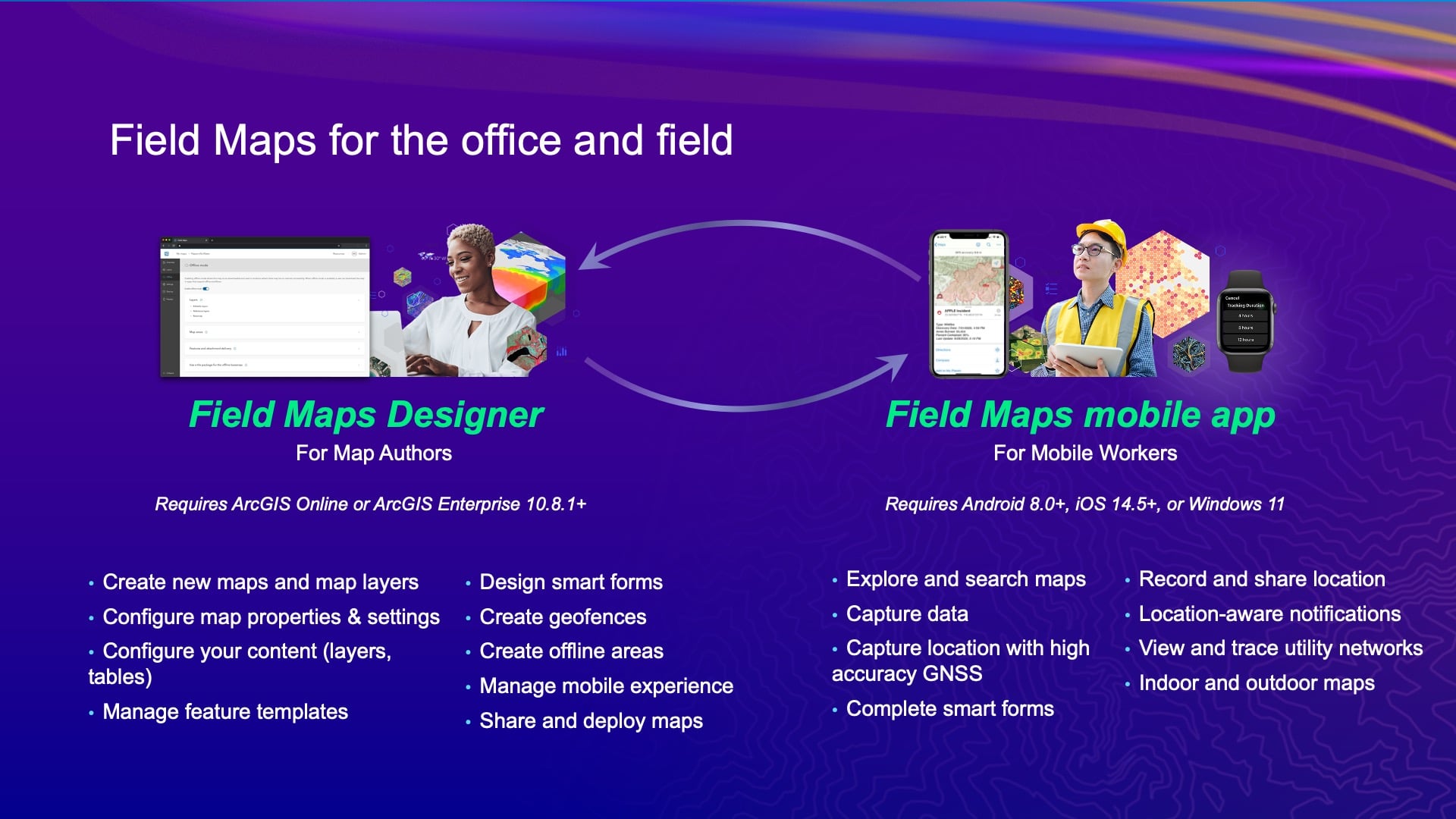
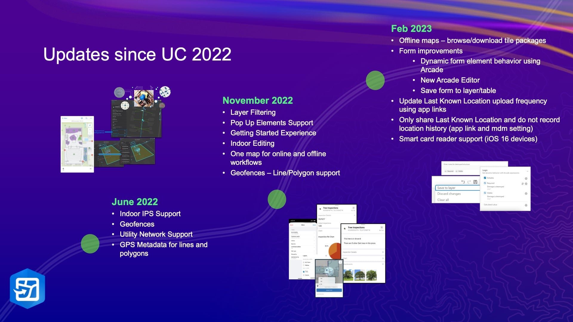
To pull all that together, we really have two aspects or two parts of the system. We have the Field Maps Designer web application, which is new for those of you that maybe have come from using just ArcGIS Collector in the past. [Field Maps Designer] helps you author maps, configure maps, configure application settings so that you make the most out of the experience that your mobile workers have to go through. And that’s kind of an iterative process, right? You want to define the maps as best you can, but then you’re going to deploy them, you’re going to learn more from your mobile crews, and you’re going to come back even a tweak — there’s a lot of back and forth. So we introduced the Field Maps Designer as a way to lower the bar of entry to get going with your project. It also is the framework by which we’re delivering a lot of the new capabilities that come into the system. And it also keeps it simple for the mobile users as we add more and more to this. We’ve been doing a lot of stuff since we got together last year. Here’s just a list of some of the enhancements. Know that we release at a cadence of every ArcGIS Online update. So last year we released it in June just before Esri UC. Then we released it in November. Then, we had an update in February, and then we had one also in June.
ArcGIS Field Maps Support for Windows 11
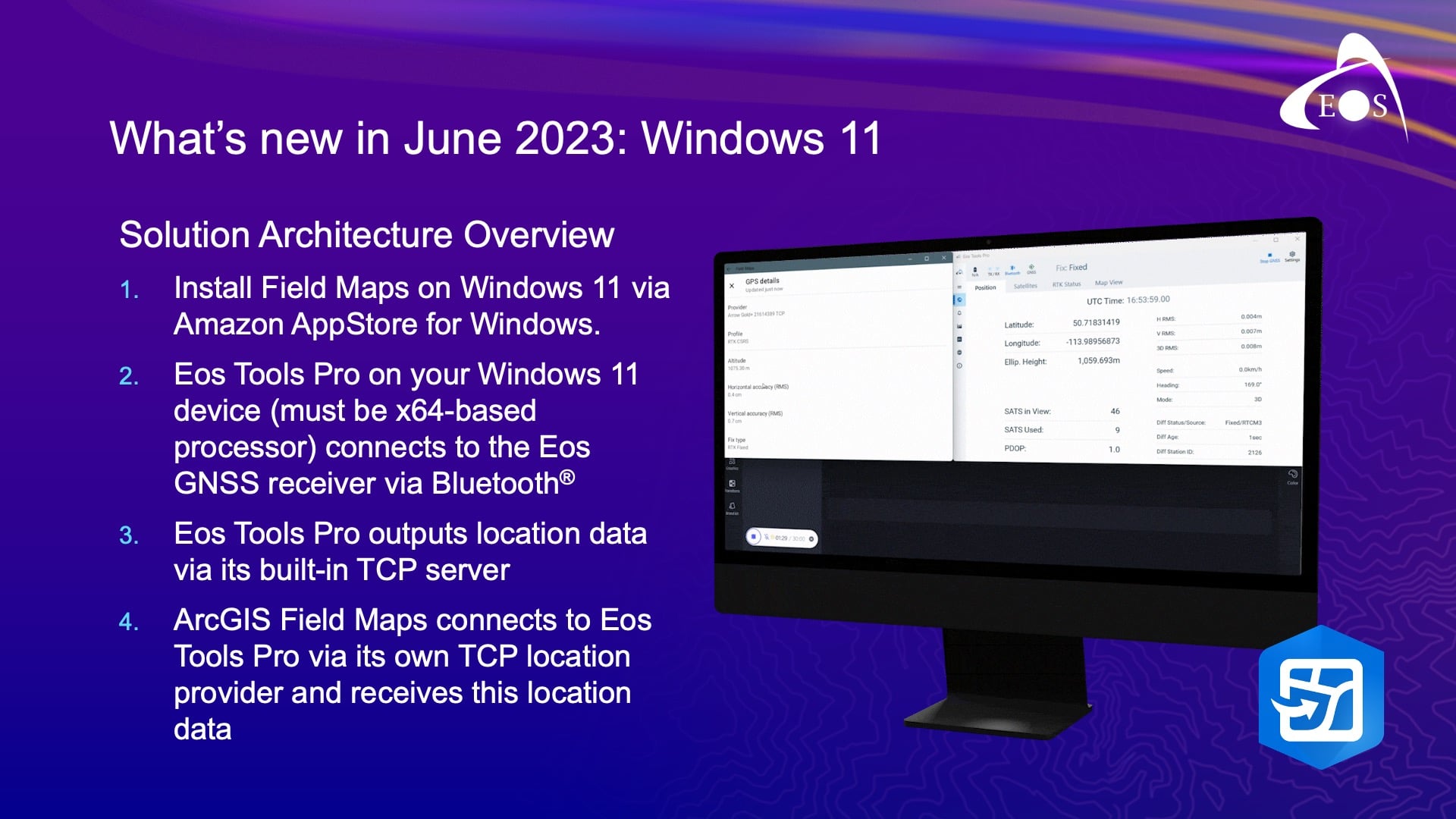
In the June update, I’ll just highlight a couple of the key things there. We introduced support for Field Maps on Windows 11 devices. So, we’re leveraging our existing Android application in that effort. We didn’t rebuild Field Maps in dot.net or anything crazy like that. Windows 11 introduced something called the “Windows Subsystem for Android™” (WSA), which is a virtualization environment on your Windows 11 device. And with that came some challenges that we had to overcome to bring all the capabilities of Field Maps to that device. And one of those was support for external GNSS receivers. So, as you are likely familiar with ArcGIS Field Maps today, you can set a location provider based upon what’s been Bluetooth® connected to your iOS® or Android™ device. And then if you’re working with an RTK network, or whatever, to define a location profile — because it’s a virtualization environment, there’s no Bluetooth support. So, we needed to introduce a TCP/IP connection. But work really closely with Jean-Yves and his team to bring that to life. Do you want to talk a bit about that, Jean-Yves?
ArcGIS Field Maps Windows 11 Support for Eos GNSS Receivers via TCP/IP Server
JEAN-VYES: Yes, after years of waiting for you for TCP/IP server? [audience laughter]
In all seriousness, it’s a very good initiative from Esri to leverage that feature on Windows 11, which is the Windows subsystem for Android, where you can run actual Android apps on Windows devices. So for Eos Tools Pro — for those of you guys who are familiar with Eos Tools Pro — we have an Android, iOS, and Windows app. And on Windows, the way we did it is that created a TCP server — so we do all the data handling when it comes to, you know, datum offsets, and we do geoid models — and any change we have to make the data we push it out to a TCP server local to the device. Because I think that WSA does not allow us to use the virtual comport that we create. But at the same time then, this in this case, Field Maps now incorporates a TCP client that simply reads a stream of data from Eos Tools Pro. So the limitations are that you cannot run this on ARM-based processors. So, if I have a new Surface Pro with 64-bit processor, it will not work; but we’re working on getting this to work with an ARM processor version, which is very uncommon usually for Eos Tools Pro to support. Also, I don’t know if you have this problem, this limitation with Field Maps running on ARM.
JEFF: With core Windows locations, no. But with any external receiver, …
JEAN-YVES LAUTURE [Eos Positioning Systems]: Right. Yeah. So, this is ready today. So, if some of you are on Windows and want to give it a try on the tablet Surface Pros or any other Windows machine, please do. But it has to be Windows 11.
JEFF: Yes, that’s correct. The Windows subsystem for Android is all in the cloud.
JEAN-YVES: Yes.
ArcGIS Field Maps Update: GPS Fixed Type Threshold
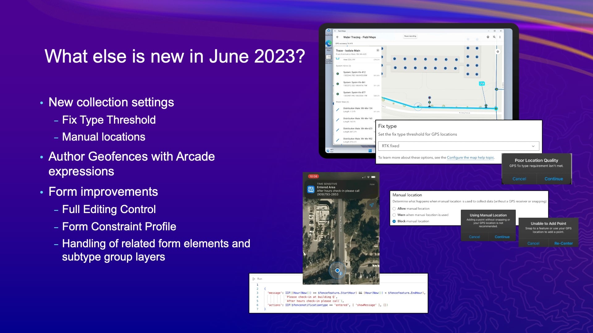
JEFF: Now, a couple other things that we did in the June release: There are a couple of new collection settings that people have asked us for. One is the GPS fixed type threshold. So, we want to make the life of the mobile user hell if they don’t get the accuracy we demand out of them, right? [audience laughs] Yeah. Because that’s what we want, is to make people’s lives hell.
So, we introduced this new setting, which isn’t on by default, so don’t worry about that. But you can define what the fixed-type of threshold should be. So, see, you’re required to get RTK fixed while you’re capturing assets, and when you lose that, and it goes to float. We can prompt — if you enable the setting — to warn the user in these cases, “Hey, you do not want to collect. You’ve lost your fixed-type of fixed view.” So that’s just a warning message. It’s not that bad. It’s just annoying. No one likes notifications that are constantly annoying. But it’ll help you ensure that data has a certain accuracy.
ArcGIS Field Maps Update: Manual Locations
The other setting we introduced is something called manual locations. So, you know, with Field Maps you can use GPS or you can use the map. And the way we define a manual location is if you move the map around and just tap to place that vertex or point location, that’s a manual location for us. Now, if you were also to snap to an existing point, we don’t consider that a manual location — because that existing point could have been GPS-ed, right? So there’s a little bit of a caveat in how we define a manual location. It also can present this really nasty warning message, but you could also block people from doing that now. So if you don’t want them to use the map to collect things — [for instance,] like Eric’s going to sit in a pub and do all of his data capture by moving the map around and trying to fool us all — now we can stop him from doing that. We can make sure that he’s actually using the GPS in the field.
ArcGIS Field Maps Update: Geofencing
Now with geofencing. We did a little bit of an update and showed it off in the plenary. You can really control the message most effectively using an ArcGIS Arcade expression. You know, an example of that is, say I want to notify someone coming that is out of the Esri campus between 9 to 5 that they have to go check into Building Q. But if it’s after five, they need to call this number. Well, you can build that logic into an Arcade expression and provide that message based upon knowing what the time is. Right?
So there are some advanced features that come in through Arcade, and that is an example of one. And there are a few other things, like we see there’s more advancements to the logic and forms there, too. I do have some slides so I’ll go through this really quick.
ArcGIS Field Maps Update: Other Designer Advancements
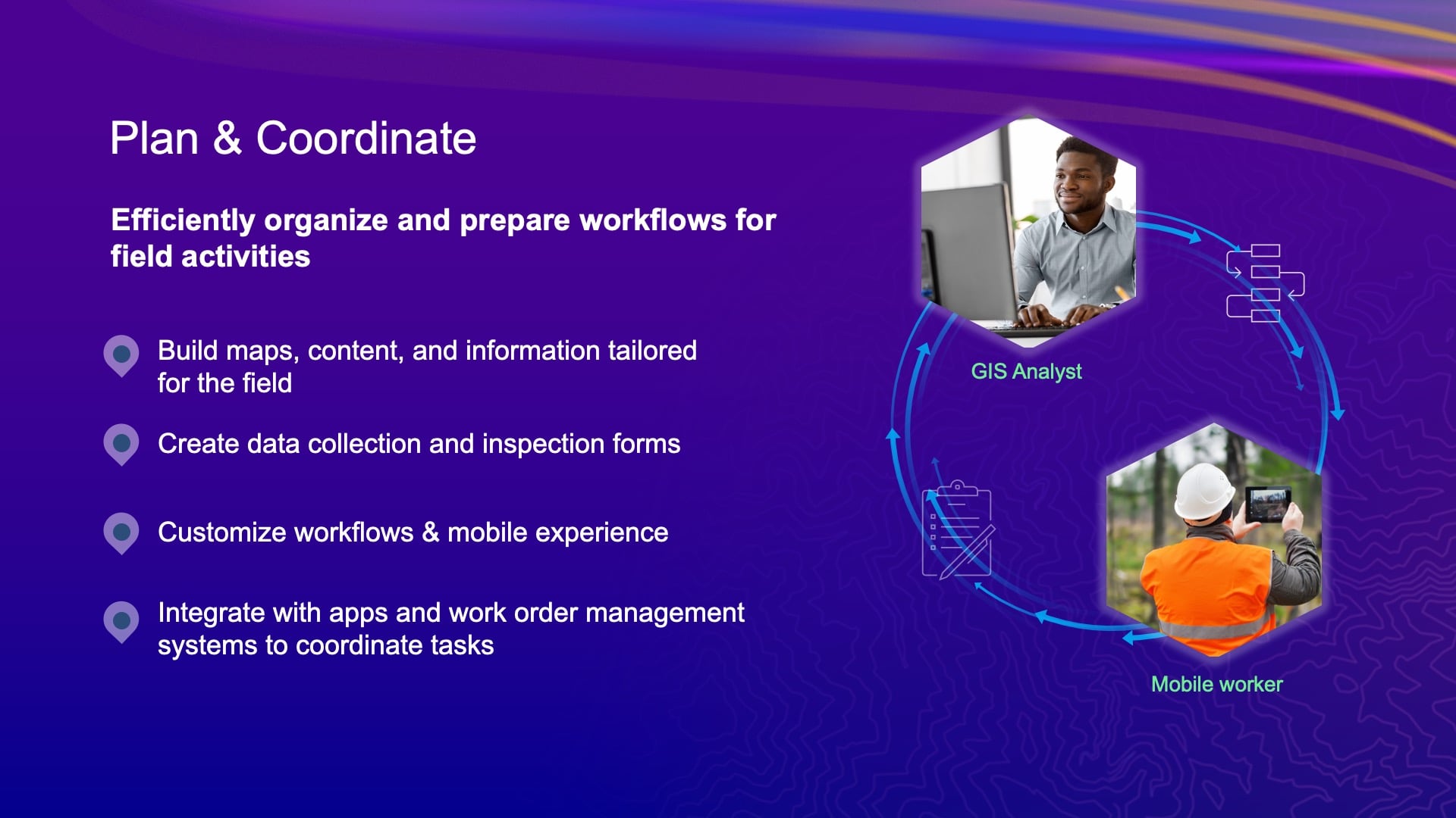
On the planning and coordination side, this is really where the Field Maps Designer comes to life. And if you haven’t started to use it, I really encourage you to do it because, like I said earlier, this is how you control the experience the mobile user has. And that could be different tools in the application; it could be the form, the definition; it could be a lot of different things.
We’re controlling, inside of the Field Maps Designer, that offline experience with the forms, that geofencing experience, and also the data-collection settings. You can set them up so that your mobile users don’t have to set them on the device itself. And you can do it at the map level as well. So, you can change those settings for different maps. And we’re going to bring much more to talk about that briefly in the road ahead.
So, think about how you can take advantage of the Field Maps Designer to really bring that experience to life for the mobile user.
ArcGIS Field Maps Update: Advanced Maps Capabilities
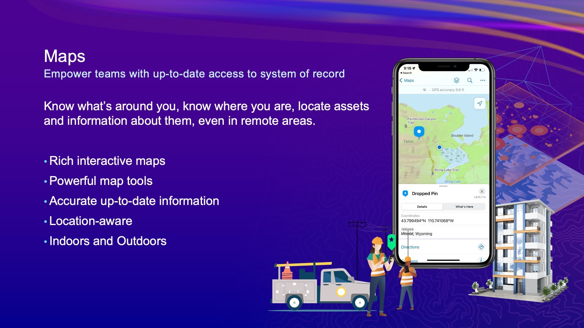
Maps. So, we think maps are kind of important at Esri. [What that tells you is that] we’re putting a lot of effort into Field Maps maps, as [implied by] part of the name. So with maps, there’s a lot of advanced capabilities that can help increase awareness. For instance, the location-sharing capability provides the opportunity for you to not only record where you are, but also broadcast where you are — and record where you’ve been. And you can configure that, too. We’ve got a lot of organizations that are using this for security operations, for worker safety, and so on. I’m going to show you an example of that from a worker-safety perspective in a second.
But the map itself and the way you configure it really brings the application to life. And pop-ups are a good example, if you didn’t know that. I hope none of you are showing object changes in your pop-ups; if you are, I’m going to find you.
To define what that pop-up looks like — that is how you present yourself for a map layer. You can do charts now, if you want, in Field Maps. You can use Arcade that will go off of other features and show you information like, if I tap on an asset then show me the last three or four inspections on an asset that might have failed, and you can show this through the related tables that have been added in. There are all kinds of amazing opportunities you can do there.
ArcGIS Field Maps Update: Indoor/Outdoor Support
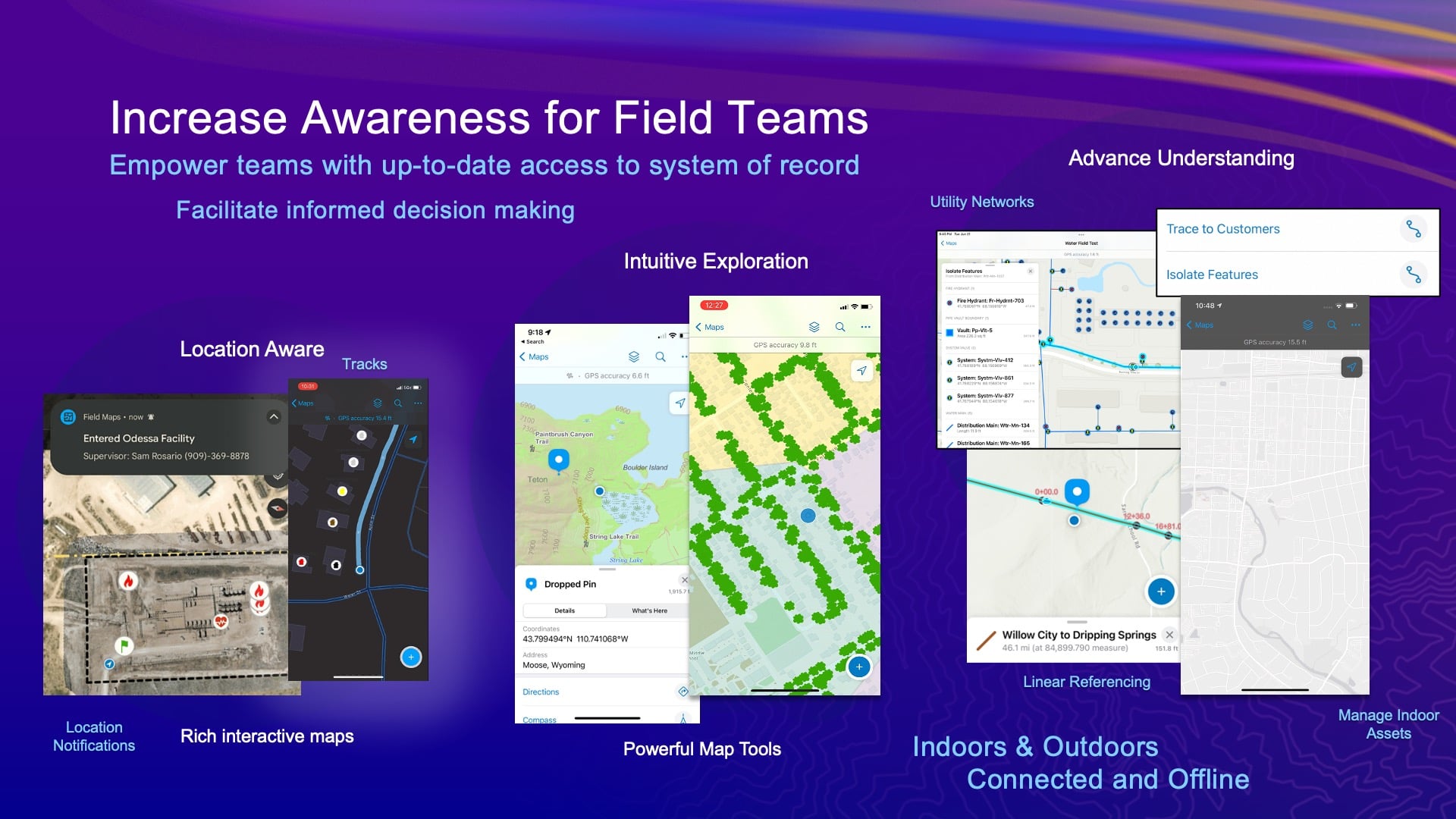
We’ve added support for indoors and outdoors use. We’ve added support for linear referencing — a whole bunch of stuff.
Let me show you this geofencing demo.
This is a customer of ours in Germany. I don’t speak German. Maybe some of you do, but the company’s name is Voestalpine. Now, what this guy is doing is he’s walking up to that blue polygon. He started to record his track, so only once he got inside that blue polygon, he started to record his locations. Now he’s approaching the red polygon. And then once he enters that red polygon, that’s the dangerous area. And it’s going to make some kind of message to tell him about the danger. If you speak German, maybe you’ll understand that “Achtung” message. But in this basic idea, this is a warning that you are in a dangerous area. Now he’s going to leave that dangerous area, and he’ll get another message that he’s left it. And then when he leaves the overall project space, it’ll turn off location sharing. This is one of the overall capabilities, independent of data capture, that Field Maps can do. And obviously, he probably shouldn’t walk across the road holding his phone. If he had a peripheral like an Apple Watch, he could prevent himself from getting run over with some kind of haptic feedback, rather than getting hit by a car.
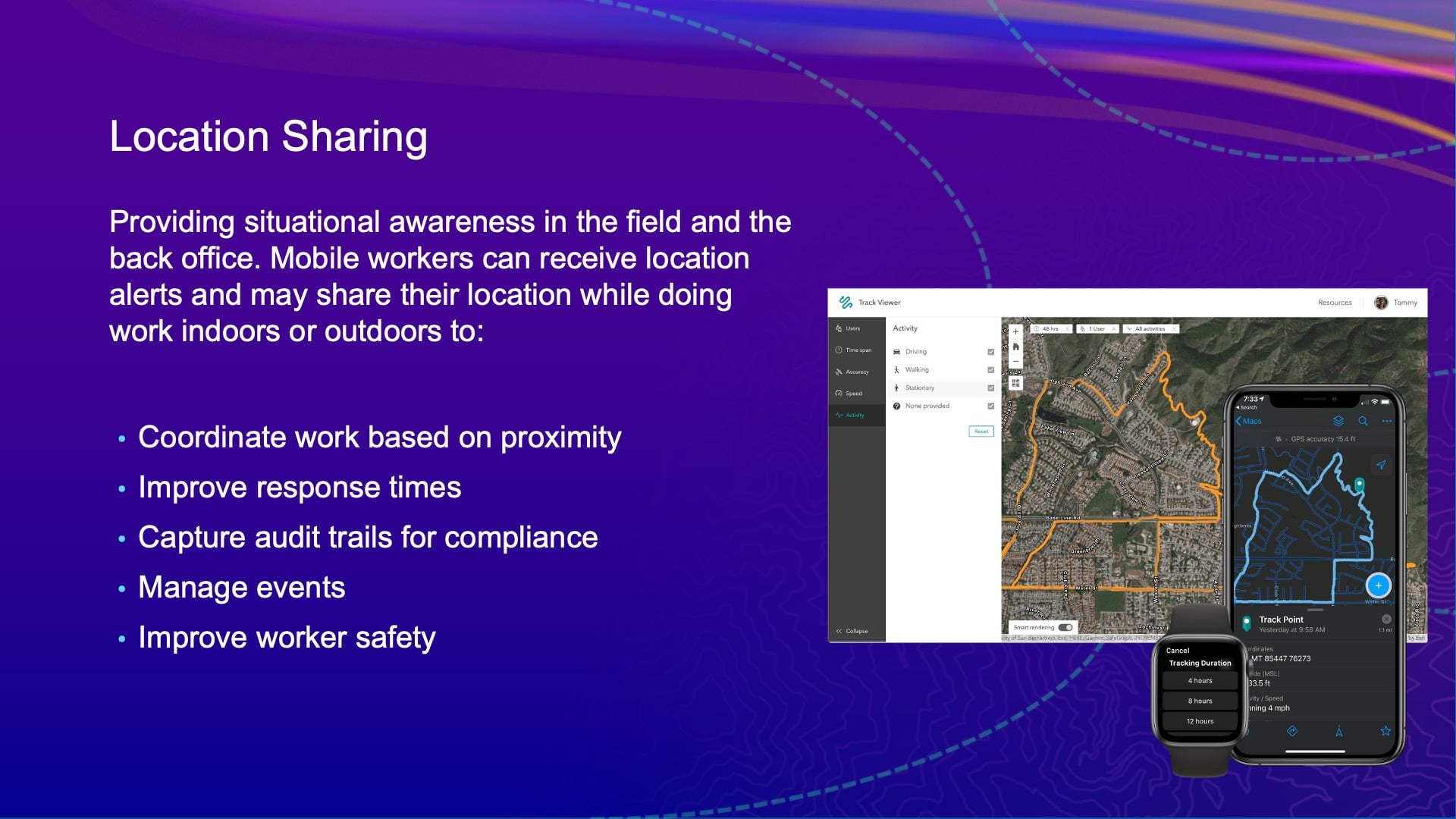
But the location sharing ability — that is a key capability. We’ve mentioned that a few times. It works offline, it works connected, and of course, it works with locations. We use a combination of location services, but also the motion and fitness APIs in your devices. So not only do we get the position information, but we also get the activity information. So we know how much time Jean-Yves is sitting versus how much time is walking and, potentially, how fast is driving, too. All of that gets stored with the data, and you can use it as analytics.
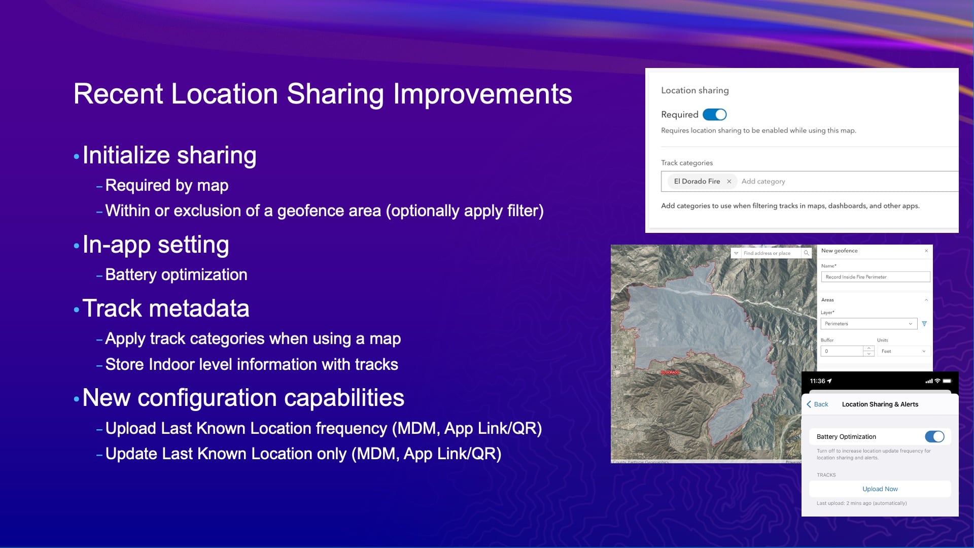
Now we’ve done a bunch of things recently with that. Obviously there’s privacy concerns around reporting and sharing location, so it’s an opportunity for the mobile user once again to make their life a little bit hell. We can say you have to turn it on to use an app, and then we can categorize the map with some string value for us to create out after, if you want. And you can configure a lot of different settings about how it’s uploading — and all that stuff.
ArcGIS Field Maps Update: Recent Data Capture Improvements
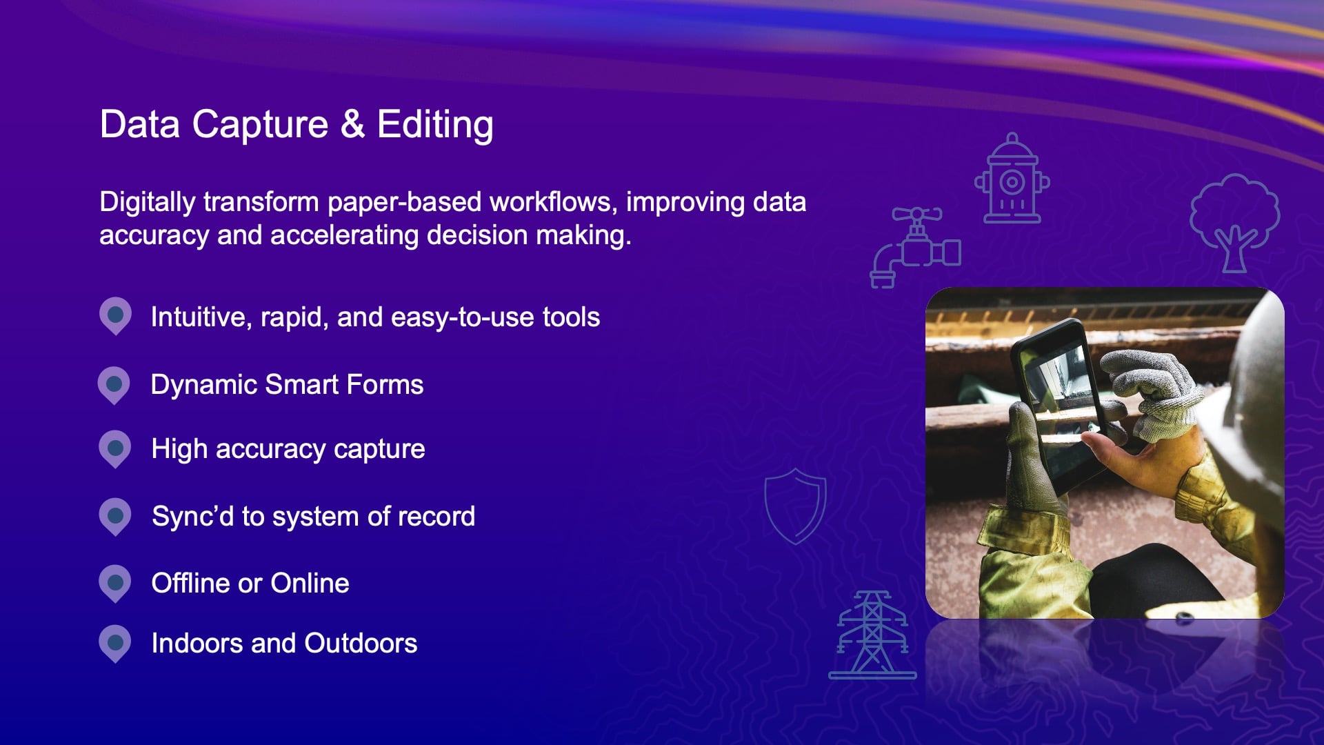
The data capture capability is what we’ve really been focusing on, and it’s been a lot of our combined efforts with some key customers that we’ve had together with Eos that have driven a bunch of the work you see here. The collection settings, I talked about that being one. The support for summary statistics and GPS metadata for lines and polygons [is another one]. [That means] knowing the worst fix accuracy or a fixed-type for worst accuracy — all that stuff is stored now for lines and polygons.
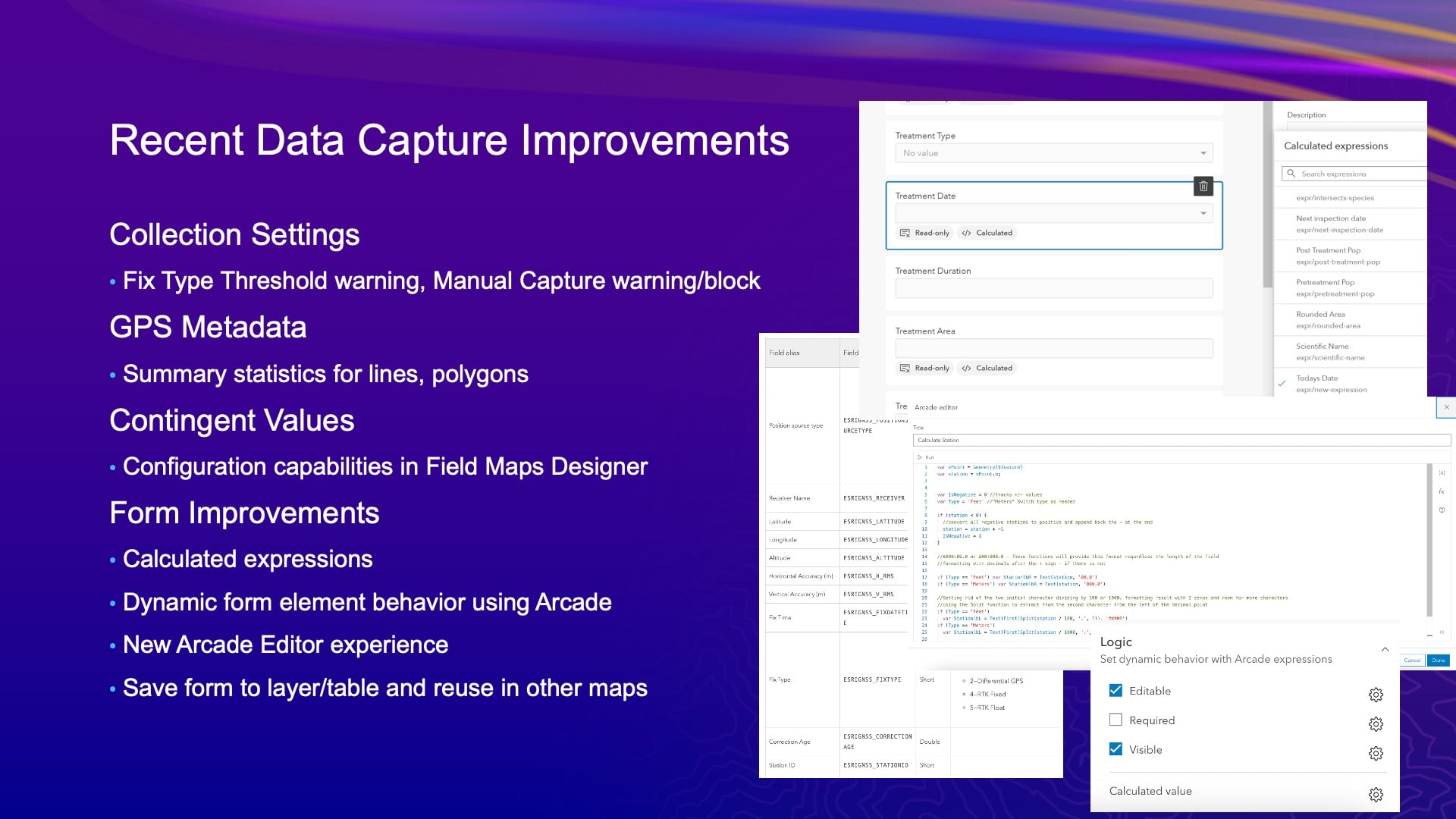
Also, [there is] all the [new] forms of work that we’ve done. You know, the use of Arcade — how many people are using Arcade today? [audience raises hands] As GIS professionals, if you’re not starting to learn Arcade, I really recommend that you do it, or you go find someone that has and hire them. Because Arcade is all over our system and, with this forms effort, with what we’ve been doing, it’s not just for Field Maps. We’ve become the authoring environment for it. But forms are stored in the web map. They’re also in our JavaScript API, and they’re also in our developer tools — the new maps SDK. So, as you move forward, like right now, the forms you authored in Field Maps Designer are used in the map viewer. They’re used in the edit widget, in the experience builder, we’re teaching ArcGIS Pro about forms so that you can do forms editing in ArcGIS Pro.
Next year we’re going to release a new web-editing application in ArcGIS Online. So forms are coming across the system architecture, and they’re all predicated on Arcade. So learning Arcade is going to be very important not just for making pretty maps, but for how you work with your data, too.
Integrating Field Maps with Location Providers Like Eos
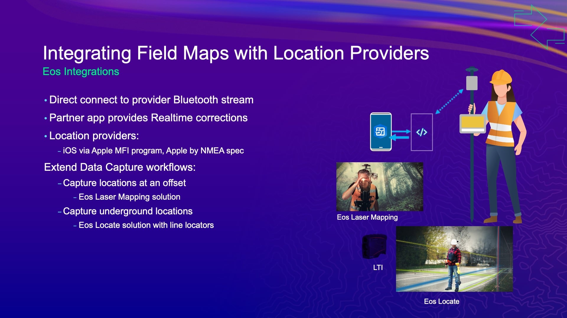
The integration with location providers is how Jean-Yves and I work together. We’re well integrated. So, the way that we do that today with the Eos Tools Pro application and Field Maps is using universal app links. So, if you’re using Laser Technology Inc.’s laser range finders to do offsetting capabilities, those all come to life through this app integration that we have with Eos Tools Pro. So, you can take the really basic data-capture capabilities that we have in Field Maps and do offsetting.
And Jean-Yves has extended that to do underground locating, and I think he’s probably working on other things that he doesn’t tell me about either. And that all comes to life through this integration. But at its core — on the iOS, Android and now Windows platforms — we have integration of location. That’s kind of where it all started.
Mobile Device Management (MDM)
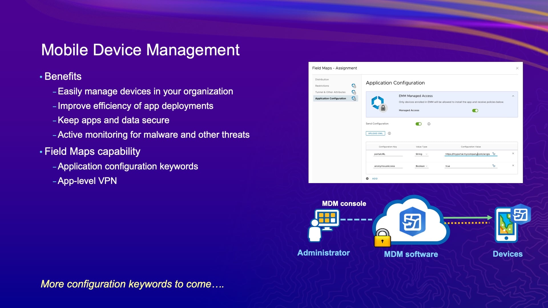
I’ve been talking about forms for a while now. But the one thing I did want to mention beyond all of that is mobile device management (MDM). Does anyone here use a mobile device management system today? You can leave your hands up — how many of you have your organization manage the purchase of the devices? I want to see if there’s a big difference. A number of you. Okay.
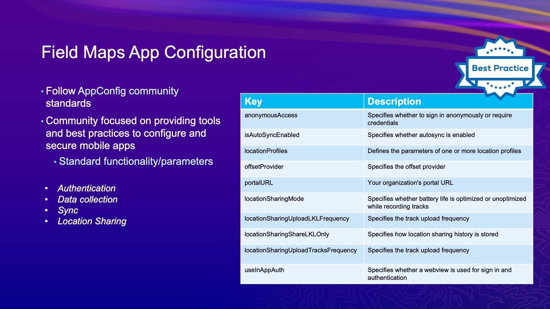
Well, mobile device management systems are very effective when the organization manages the devices for you. It’s the way that you can deploy updates to our system, but it’s also a method by which you can configure capabilities of our system. And that’s done through what we call Application Configuration Keeper. And we work together on some of that too. So imagine, you have a standard setup. You know what location profile you need to work with in Field Maps. You’re always going to work with an Eos receiver. You have a number of settings. Maybe you work with ArcGIS Enterprise vs. ArcGIS Online, and no one wants to enter that portal URL, it’s horrible, inside of Field Maps. All of that can be pushed to the device as what we call “application keyboards,” and we work together on that stuff too, right, Jean-Yves? And I think you want to talk a bit about that as well.
Eos MDM Implementation
JEAN-YVES: Yes, but before I’ll go back a little bit to the integration that we do with Esri. With so much Arcade being used in Field Maps, what we’re doing to enhance integration is pushing more Arcade scripts — Pitfall, Q*Bert, PAC-MAN, Millipede, Centipede.
[audience laughter]
Oh, it was funny! Well, some of those games are as old as we are. I played arcade games at university.
So, MDM. Regardless of how big your organization is, whether it is medium or large size, sometimes you want to streamline your [internal technical support] process. If you have one person in the company taking care of tech support for all field technicians, sometimes they don’t want to respond to constant individual settings issues. They want to do other things. So MDM really helps there, where you can predefine a whole bunch of configurations ahead of time and push it to the deployments — the mobile devices in the field. It’s less complicated than you think. It’s doable, I would say, for any size organization. A lot of the tools to deploy, I think they’re even free.
JEFF: Yeah.
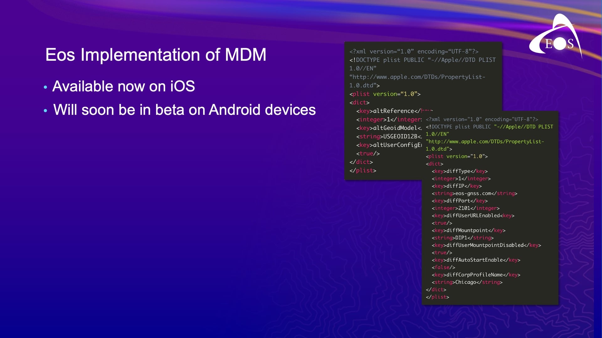
JEAN-YVES: Now at its core, MDM is basically just a whole bunch of scripting that you have. On our end, Eos gives you the basis of the file, which you can modify to what you want. For example: maybe you want to predefine the alarms that you’re going to get from Eos Tools Pro. You can create a profile with the default values for the user and you can log certain fields so that the user in the field does not change them. So, no more calling you to say, “Hey, what’s my password?” Right? You can put all of this already predefined in MDM.
Now we have developed our MDM for iOS first, and we have also developed an MDM for Android, though it has not been released yet. It will probably come later in the summer. For Windows, we have no plans yet for that, but eventually if there’s demand, we will incorporate an MDM also for Windows.
Eos Tools Pro MDM Generator
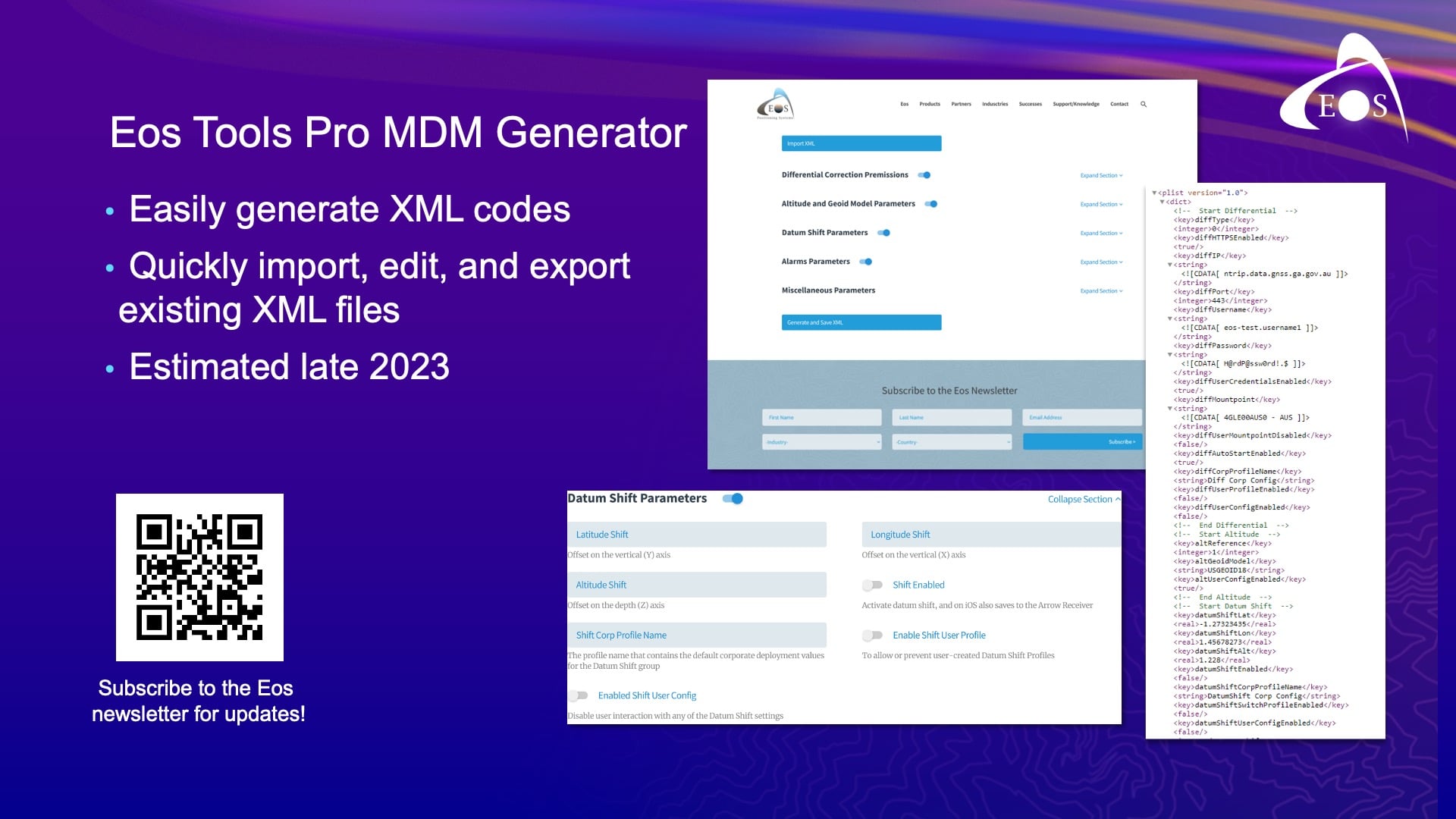
And also, to make your life easier — the Eos Tools Pro MDM Generator. MDM is basically XML files that you program. And, you know, it’s easy to make mistakes. One typo and suddenly your file is not recognized.
So, what we are doing right now is creating an MDM generator form. So on the website, you can either create a new XML file or upload and edit an existing one. Then you can save your output to an XML file, which you can use for your MDM deployment. Within the generator, you’re going to have pull-down menus, and you’re going to have fields that you can lock and unlock to allow users to edit those fields or not. This won’t be for quick deployments. But, I think it will make life easy. Instead of writing codes, you’ve got pull-down menus with various categories.
So this list of MDM capabilities will evolve. We have a little documentation online on our website, and at any point you can give it a try. It’s free. Those of you who are using Eos Tools Pro for iOS, you can use it today. You can find the MDM just by searching our website for MDM.
Also, there’s a very good presentation tomorrow by Randy Winston of Indiana American Water. He will give a presentation called “Leverage Mobile Device Management to Streamline Field Data Collection” at 1 p.m. in Grand Ballroom 6 at the Marriot. Randy will show how he deployed MDM with both Field Maps and Eos Tools Pro, as well as the advantages that he got, the challenges that he found and overcame, and the benefits of deployment. So I would really encourage you, if you want to learn more about MDM, to watch his presentation.
JEFF: Back to me, and I’m just about done, I promise. To finish our thoughts on MDM, this is just a list of Field Maps app configuration keywords that we support with MDM.
ArcGIS Field Maps Updates: What’s Coming in the October 2023 Release
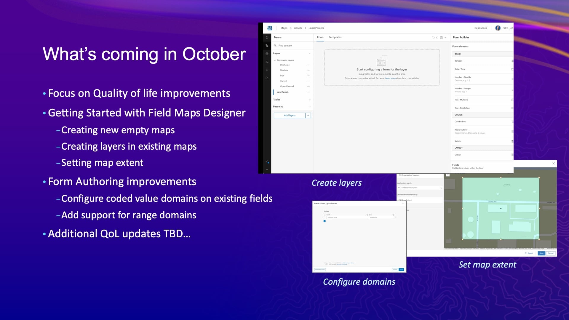
I wanted to talk briefly about our next release. So we’ve got another release coming this year. It’ll be in October. This release is going to focus more on that Field Maps Designer experience than anything else. And really, if you think about it, that means quality of life improvements overall.
Like I mentioned, we’ve supported getting started by creating a map inside of the Field Maps Designer. We affectionately refer to Designer’s value as eliminating the ping pong effect of going between all the different web apps inside ArcGIS Online. It can get complicated and you can get lost. So, the more you can do in one app, the easier it is. So right now you can create a map, you could add layers — all that stuff — and kind of round out that experience with some new capabilities there, and you can button up a few things we haven’t done with form authoring.
At the same time, we’re also working on a pretty major update to Field Maps on the mobile side. We’re going to introduce a new planning and coordination capability. We’re going to start supporting offline utility networks, offline attribute rules, and to really bring that to life, we’re modernizing the Field Maps architecture with the new versions of ArcGIS Maps SDK.
Field Maps Designer: Planning & Coordination Tools to Replace ArcGIS Workforce
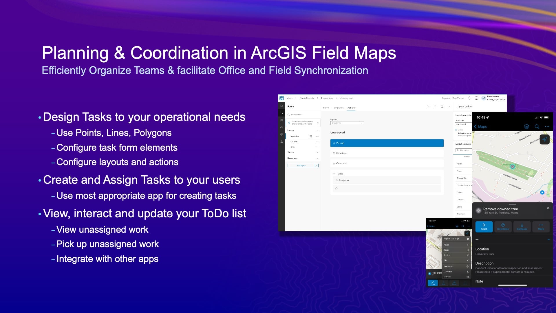
Just to dive in a little bit on the planning and coordination bit, this is going to replace the product we know as ArcGIS Workforce. So if you’ve used ArcGIS Workforce, this is going to be a new capability for your Field Maps users to have a digital to-do list on their device. The way that will come to life is in the Field Maps Designer. You can add a new tasks layer to your map — tasks could be points, lines, areas, etc. They could have a form associated with them that you have full control over, so you can extend it with whatever fields and form elements you want. And then you’ll be able to lay out the logic behind all that form. And this is another place where Arcade is going to come in. So, you’re going to have control over the different types of status of work. Now, that’s something we never let you do in ArcGIS Workforce either. And then with each iterative part of the status, like from line, to progress, to completed, you can choose what tools and behavior happen as that status changes. So, all that will be configurable in Designer and executed in the mobile application.
One of the big things there that we’re not going to do, at least not in the short term with the tasking capabilities, is force a dispatching web app down your throat. Because it’s founded on the feature service and the form capabilities that have evolved so much, you can build your own. You can use ArcGIS Experience Builder, you could use an instant app, or you can just use the Python API. We’re going to make it very open and easy for you to create work that can be assigned as part of someone’s to-do list. And it will also let you use a mobile app to do that too, by default anyway. So, if I’m doing an inspection and I notice something else that needs to be done, well, I could create a new task that assigns to myself that could then be filled out later and maybe added to a work management system if you’re doing integration with it there.
Also, this probably would never happen to Jean-Yves, but he might finish his work at 4:00 and then have nothing assigned left to do. Well, he’d be able to go and see what hasn’t been assigned and pick it up and start to do it. Jean-Yves, I’m just saying you’re too busy.
JEAN-YVES: [laughs] I know.
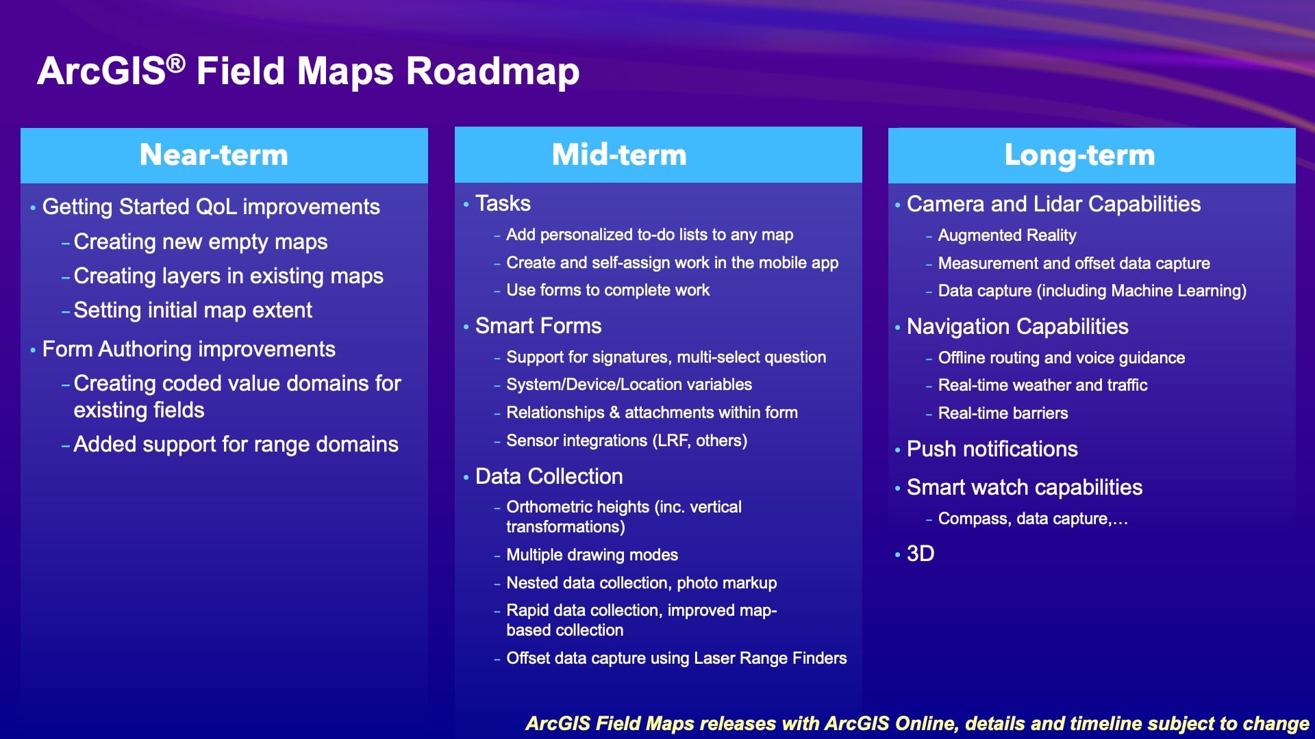
JEFF: So that’s kind of our work in front of us, and we’re going to start a beta program on the task capability late this year. So look for that. And this is just a bucket list for us; there are of lots of long-term items that we want to address in the future. Then we’ll start to look at those more next year. So, come talk to us. Thank you.
What’s New in GNSS Signals?
ERIC GAKSTATTER [Discovery Management Group]: Well thanks. My name is Eric Gakstatter, and I’m going to talk a bit about high-accuracy GNSS.
So, any high-accuracy users in here? Just to get some kind of idea. Any RTK users in here?
Okay, we’ve got good crowd.
I’m going to talk about three things this afternoon. And one of them, I have to say — I’ve been doing this for 30+ years now. I wrote for GPS World Magazine for probably 10 years about high accuracy. I was their contributing editor. I was able to travel around the world consuming different ideas and technology about high accuracy. And I have to say that in my 30 years of doing this, this first topic is really one of the handful of developments that I really thought was amazing in high-accuracy GNSS technology. And that is the new Galileo High Accuracy Service (HAS).
Galileo High Accuracy Service (HAS)
I probably started 10 or 15 years ago. Over the years, I would go over Brussels, where the E.U. Galileo program was based to begin with. Then probably seven or eight years ago, the base transferred to Prague in the Czech Republic. Now, about every two or three years, I go over there and consult with them and sort of give the U.S. perspective about what the needs are in the U.S. market, or what people think about in the U.S. market for high accuracy. And on the subject of high accuracy, one question always comes up: “What kind of demand is there for high-accuracy GNSS in the U.S.?” And I said, “It’s there. People are using RTK already. They’re using SBAS with WAAS. So the demand is there.”
And they had this capability that was really unique. And there was this debate within the organization throughout the years about whether they charge for this service or not. So initially, the operators of Galileo were going to charge for this high-accuracy service. And finally, at one point, they decided they weren’t going to charge for it. And so the last meeting I had with them was probably two or three years ago, just prior to COVID, in Prague, and they said, “Look, we’re getting ready to deploy Galileo High-Accuracy Service.”
Interestingly, just from a business standpoint, they were afraid of competing with the private satellite services industry, because Galileo is a public entity. Granted, it’s a consortium of 27 E.U. countries, but it’s a public entity, per se. So they were concerned about that, but anyway, they went ahead and deployed it. Galileo HAS was deployed this year in beta, and I think it’s still in beta; Jean-Yves can talk more about that a little bit. But it is deployed, and it’s usable today. And so, this has been pretty exciting.
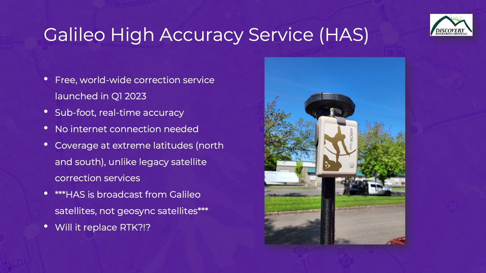
Different Differential Correction Services: SBAS vs. RTK vs. Galileo HAS
What Galileo HAS means, in a nutshell, is that you can now get subfoot accuracy in real time. So this differential correction service is sort of in between SBAS and RTK [in terms of accuracy level]. SBAS is submeter, right? So SBAS, which in North America specifically is WAAS, will provide anywhere between 10 cm and 1 m accuracy, depending on [conditions including] how the sun is behaving and how the ionosphere is behaving. So, some days WAAS looks really great, and some days it doesn’t look so great. But then a step better from that has always been RTK at the inch-accuracy level. But what’s required for RTK? Connectivity. Internet connectivity. You’ve got to be able to connect to a base station.
So Galileo HAS is in between these two [RTK and SBAS (or WAAS)]. Remember, WAAS [and other SBAS] doesn’t require connectivity at all. The FAA created a system to broadcast corrections from a geosynchronous satellite. It’s all transparent to most field workers, because it just works. Galileo HAS is the same way, but at an even higher accuracy level. So while WAAS is a submeter type of solution, Galileo HAS is a subfoot or better solution. Later on, I’ve actually got some data that I’ve collected myself to show you what the performance is that you could expect when using Galileo HAS.

Galileo HAS: No Internet Connectivity Required
One of the true beauties of Galileo HAS, and this is sort of the Achilles heel of RTK, is that it doesn’t require an Internet connection at all. What happens is the Galileo satellites have a different frequency, in other words a different channel dedicated to providing corrections to the user on the ground. And all you need is the right kind of receiver to receive and apply those corrections. So, you can be out in west Texas where there’s just no cell coverage at all and be able to use this high-accuracy Galileo HAS service for free. That’s the cool thing about it. It’s completely free.
Testing Galileo HAS at Extreme Latitudes
Then there’s coverage at extreme latitudes. Now I’ve been up in northern Alaska and down to South America. Maybe some of you have experienced what I’m going to mention. When you get these extreme latitudes, WAAS becomes much more difficult. And why is that? Because the WAAS geosynchronous satellites are above the equator. They are at 0° latitude. The further north to the south you travel, the SBAS satellite gets lower on your horizon. So you have a more difficult time receiving that correction from the WAAS satellite.
Galileo HAS is different than that. Its signals are broadcast from each Galileo satellite. Think about that. There are about 24 or so Galileo satellites at any one time. And the HAS corrections are broadcast from each one of those satellites. So no matter which latitude you’re at, it’s likely you’ll have good reception of these signals. No matter where you are, you’re going to get access to at least one Galileo satellite.
Another place where this advantage comes up is due to topography. This happens in Alaska, for instance, or if you’re in a valley surrounded by mountains. Now, I’m from Oregon, so there’s lots of topography in Oregon. If your connection or visibility to that one WAAS satellite on the horizon is interrupted by any topography, you’re not going to be able to receive that WAAS connection. With the Galileo HAS system, again, you mitigate this, because those HAS corrections are being broadcast from each Galileo satellite.
Those are the two key things in my mind that make Galileo HAS really unique. In addition to the accuracy, there is no need for Internet connection, and the corrections are broadcast from every Galileo satellite.
Will Galileo HAS Replace RTK?
Okay. So, will Galileo HAS replace RTK? Well, no. I remember talking to Charlie Trimble, who founded Trimble Navigation 20 to 30 years ago, and he said, “Accuracy is addictive.” And it is! Once you’ve gone down to the RTK level and you’ve experienced an RTK fixed in 2 seconds and are getting a centimeter level of accuracy, it’s hard to go back. But I think there’s a sweet spot in there for Galileo HAS. It can serve as an augmentation to RTK. In regions that have got spotty Internet coverage, where you lose RTK, Galileo HAS can fill in automatically in the field, so you don’t even feel the transition. You won’t feel a loss of cell connectivity; you’ll just transition between RTK and HAS, back and forth.
Only Specific GNSS Receivers Support Galileo HAS
So that’s the picture. It takes a specific GNSS receiver to receive this Galileo HAS connection, and Eos had planned that ahead of time. They knew this was coming, so they developed the Arrow Gold+™, which we’ve tested. It’s got a special antenna because it needs to support a different frequency. You’ll see on another slide here that the Galileo satellite is broadcasting on it. But here’s a picture of the receiver. It’s just a 1-pound receiver on top of a range pole, with a relatively small antenna on it.
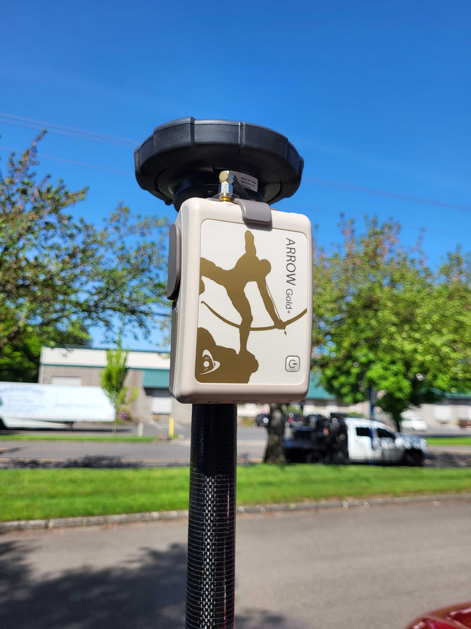
Testing Accuracy with Galileo HAS
So, obviously the first thing I want to do as a person who enjoys playing with technology is I want to test anything new. So, I tested the Arrow Gold+ with Galileo HAS earlier this year. This [result] is probably [from] the March timeframe, I think.
Galileo HAS Convergence Time
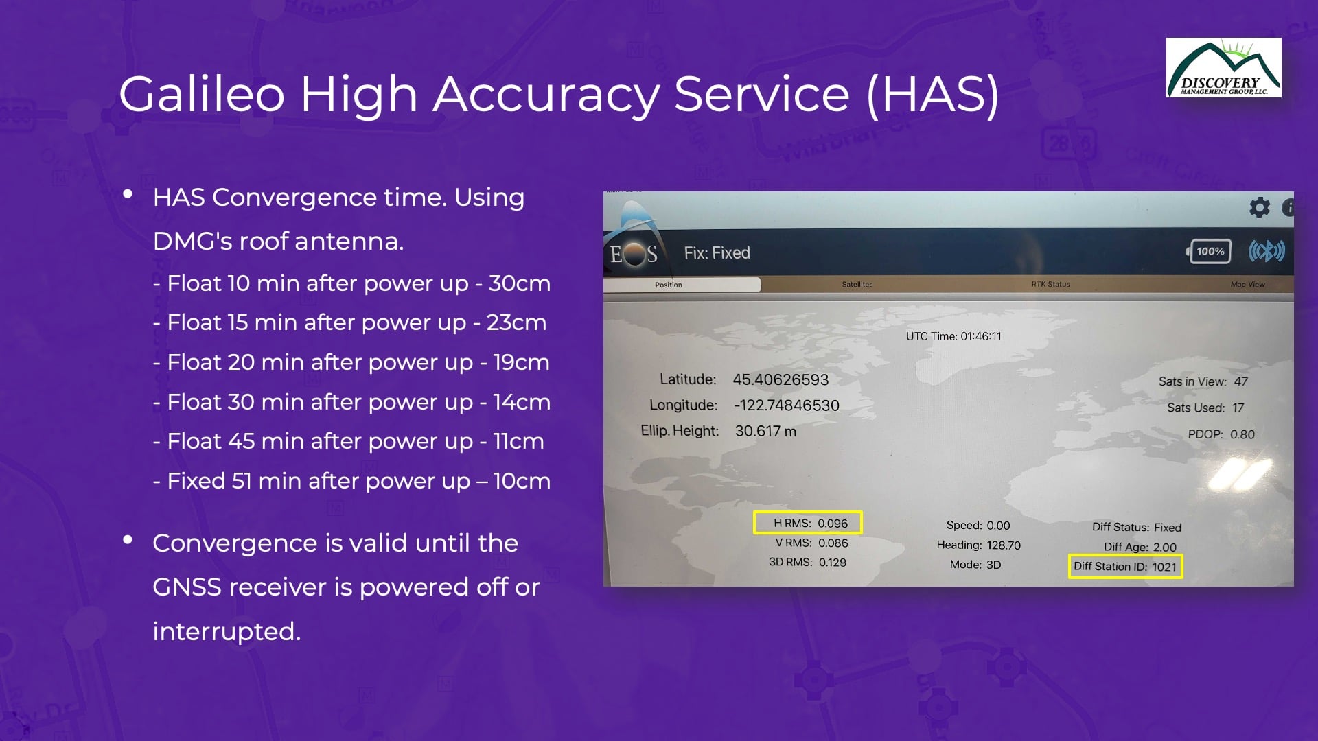
Now, one of the gotchas of the Galileo HAS [beta] is what we call “convergence time.” If you’ve used RTK, you know that once you connect to the RTK base station, it takes two or three seconds in your fixed solution, and then you get 1 cm accuracy. Galileo HAS isn’t like that. It takes convergence time to get there.
What is that convergence time? How long does it take? Well, here are my experiments from my roof antenna up in Oregon. After about 10 minutes, I’m down to 1 foot level of accuracy. What convergence means is taking a one-time action of letting the receiver and antenna sit; in this case, we did 10 minutes. In that time, it will achieve that accuracy. Then you can start moving around. And actually, you don’t have to be stationary when you’re converging. You can put it on the roof of your truck and be driving to a job site, and you can be converging during that time. You don’t have to be stationary to do that. But the longer you allow it to converge, the better accuracy it will get.
So in another case, after a two-minute convergence, I was at about 30 centimeters. In 15 minutes, I was at 23 centimeters. In 45 minutes, I was down to about 11 centimeters, or about four inches. Now once you allow your receiver to do that one-time convergence, you’re good for the rest of the day until you power down or otherwise interfere with the antenna.
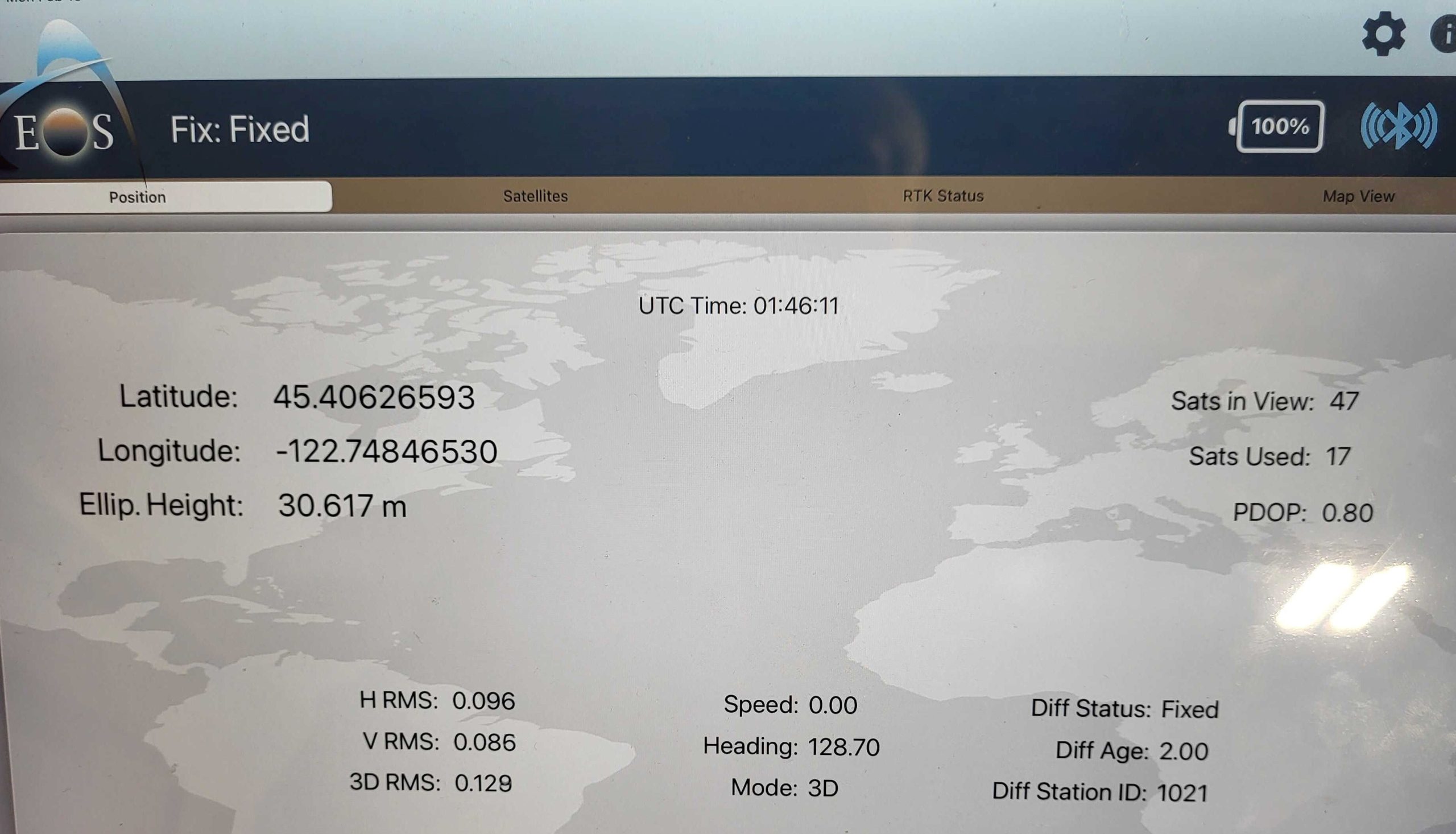
There’s a few things other things to note here. If you look on this screen, this shows results after about an hour of convergence time — with about 10 cm accuracy, or four inches. We also know that the corrections are coming from the Galileo HAS because of this [GNSS monitoring mobile app] field in the lower right-hand corner. The field is called the “differential station ID.” Every RTK base station, WAAS satellite, Galileo satellite — whatever you’re using — is broadcasting a unique differential station ID. That lets you know which correction source you’re using at any particular time. So that’s just a screen to show you my experimentation. I played with it many, many times. But these results are pretty typical.
I know Jean-Yves might want to comment on the results he’s gotten in different regions of the world, so you’ll have different performance expectations. My results were from Oregon. I’ve tested Galileo HAS from our office in Florida, and there we had similar results. I would expect that throughout continental U.S., we should see something consistent.
And keep in mind this is the beta. Galileo HAS is not done with this release. This is the beta phase of yet another phase, where they are going to reduce this convergence time dramatically. Right now, they are saying that it will probably be about 5 to 10 minutes. That’ll be the best [convergence time] you can ever hope get, because you will still always have to converge. (For that reason, Galileo HAS will never compete with RTK, either on a convergence time or an accuracy level.) But man, I’ll tell you, you’ll be able to get solid subfoot accuracy — with no Internet connectivity — anywhere in the US. It’s pretty impressive actually. So that’s Galileo.
The Importance of Four Constellation GNSS Signals
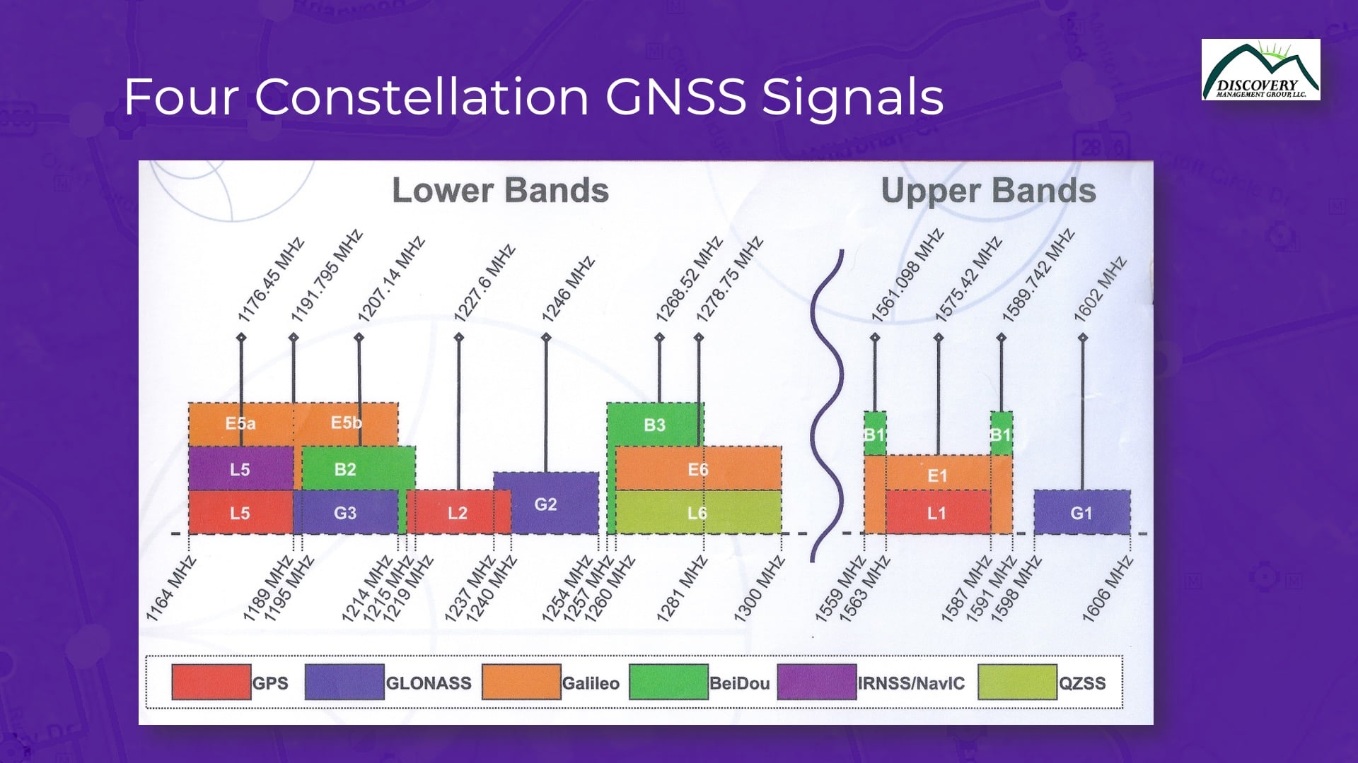
Next, I wanted to transition a little bit to a somewhat related, but new subject. Because there’s a lot of confusion, still, in the high-accuracy market about GNSS constellations. People think, okay, my receiver supports four constellations. (Remember, there’s four global constellations of satellites, which is huge compared to 10 years ago.)
GPS: the U.S. constellation,
GLONASS: the Russian constellation,
BeiDou: the Chinese constellation, and
Galileo: the European Union constellation
They’ve all launched their own systems, and they’re all pretty good systems.
Now the key is that your receiver [should support all four constellations] if you really want to optimize performance. I’m not talking about accuracy here; four constellations doesn’t help accuracy. Having more satellites doesn’t help accuracy. What does it help? Performance.
Four GNSS Constellations Improves Performance
For you folks who used to use GPS-only receivers and then started using receivers that supported both GPS and GLONASS, what happened in the field? All of a sudden, you work faster, right? You don’t have to stop during the day. And so extrapolate that to adding on BeiDou and Galileo. These two extra constellations from the Chinese and European governments accelerate that performance enhancement even more.
Up in Oregon, we’ve taken thousands of test points in field experiments, including in places where we have some nasty points under some heavy trees. And we’ve really proven with our test results that having four constellations dramatically improves performance. There’s about a 50% productivity increase when using four constellations over just two. The conversation is no longer about accuracy; it’s about being able to get more done during the day.
What to Look for in a GNSS Receiver
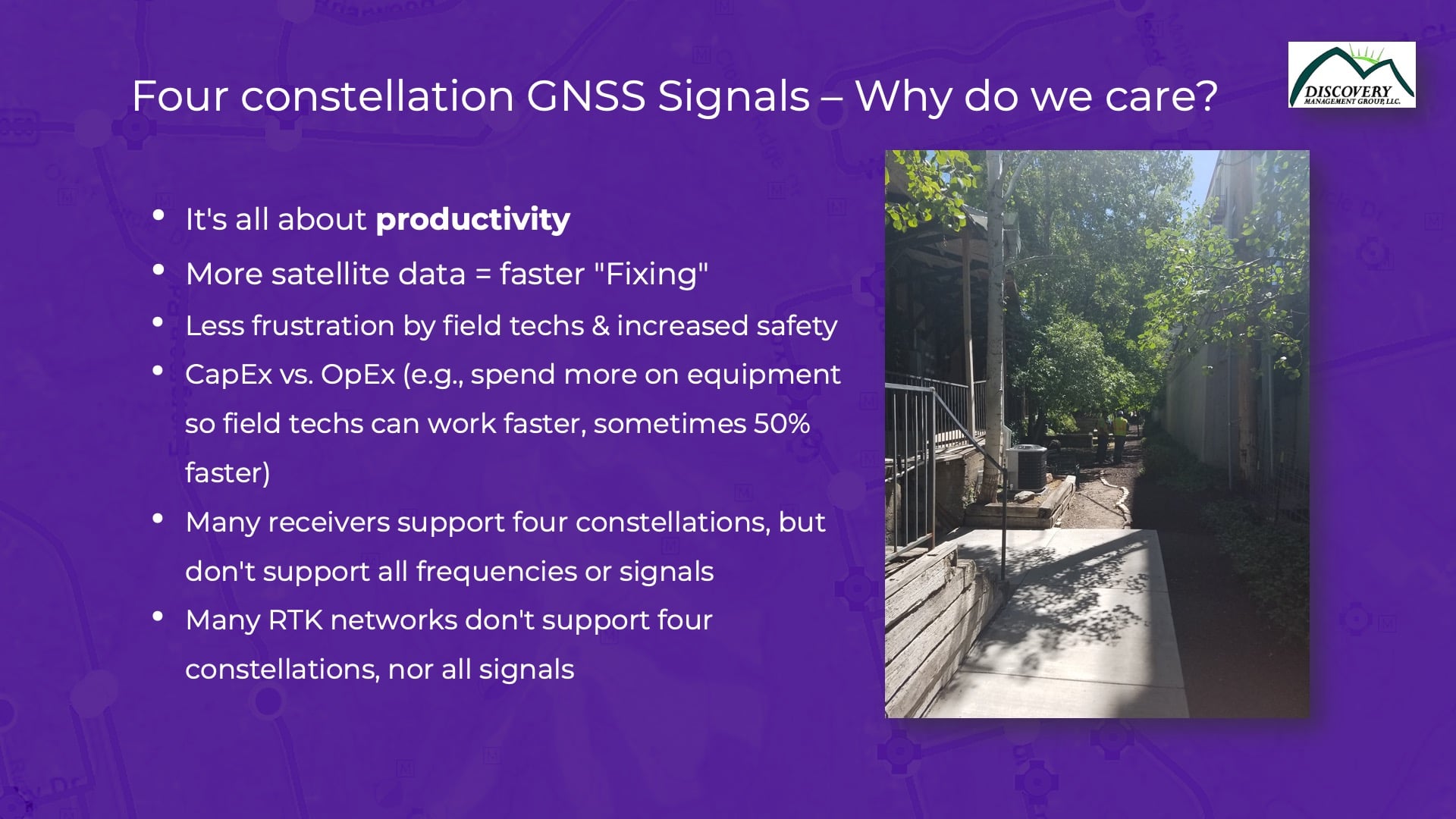
You want to look for a receiver that supports all of these [constellations]. There’s lots of receivers out there that say they support four constellations, but they often only support a subset of them. They pick and choose [and it’s often because] either the receiver is not powerful enough for the CPU, or the receiver isn’t powerful enough to process the data from all these signals. Ideally you want a receiver that uses all four constellations and all these signals. That’ll give you the max performance in the field. You might have to spend a bit more money on that receiver to begin with, but it’ll be paid for in your operational costs and frustrations. Your users will be less frustrated and be able to work faster in the field. And it’ll pay for itself because these receivers are good for seven to 10 years. You know they won’t be obsolete in three years.
This next slide is an extension of the previous slide. We covered productivity and how having more satellite data means faster fixing, less user frustration — the whole [capital expense] CapEx versus [operational expense] OpEx discussion: You can spend more on CapEx capital equipment in the beginning and be more productive, so it’s going to more than pay for itself over time. We’ve got so many ROI cases where we prove to folks, if you spend a bit more money upfront, you’re going to save that and more in operational costs down the road — while reducing user frustration.
This is a great example right here, this picture on the left. This is down an alleyway in Salt Lake City, where we were doing some field tests with a utility company. They were saying, “Look, we can’t get a solution down this alleyway.” There were four-story buildings on either side, they were using two-constellation equipment during that time. We recommended they try using four constellations and were able to find a solution. Four constellations was a difference-maker in that kind of tough environment. Out in the wide open in parking lot, whether you use a GPS-only or four-constellation receiver, it’s probably not going to make a difference. The difference is when you start to work in these challenging environments. That’s where a high-performance four-constellation receiver really makes a productivity difference.
Setting Up Your Own RTK Base Station
The third and last subject I want to cover is base stations. If you’ve watched me speak about this before, I’ve talked a lot about how to set up your own base station. This is still a common story today — I’ll give an example.
Why Customers Set Up Their Own Base Stations Despite Having Free State RTK
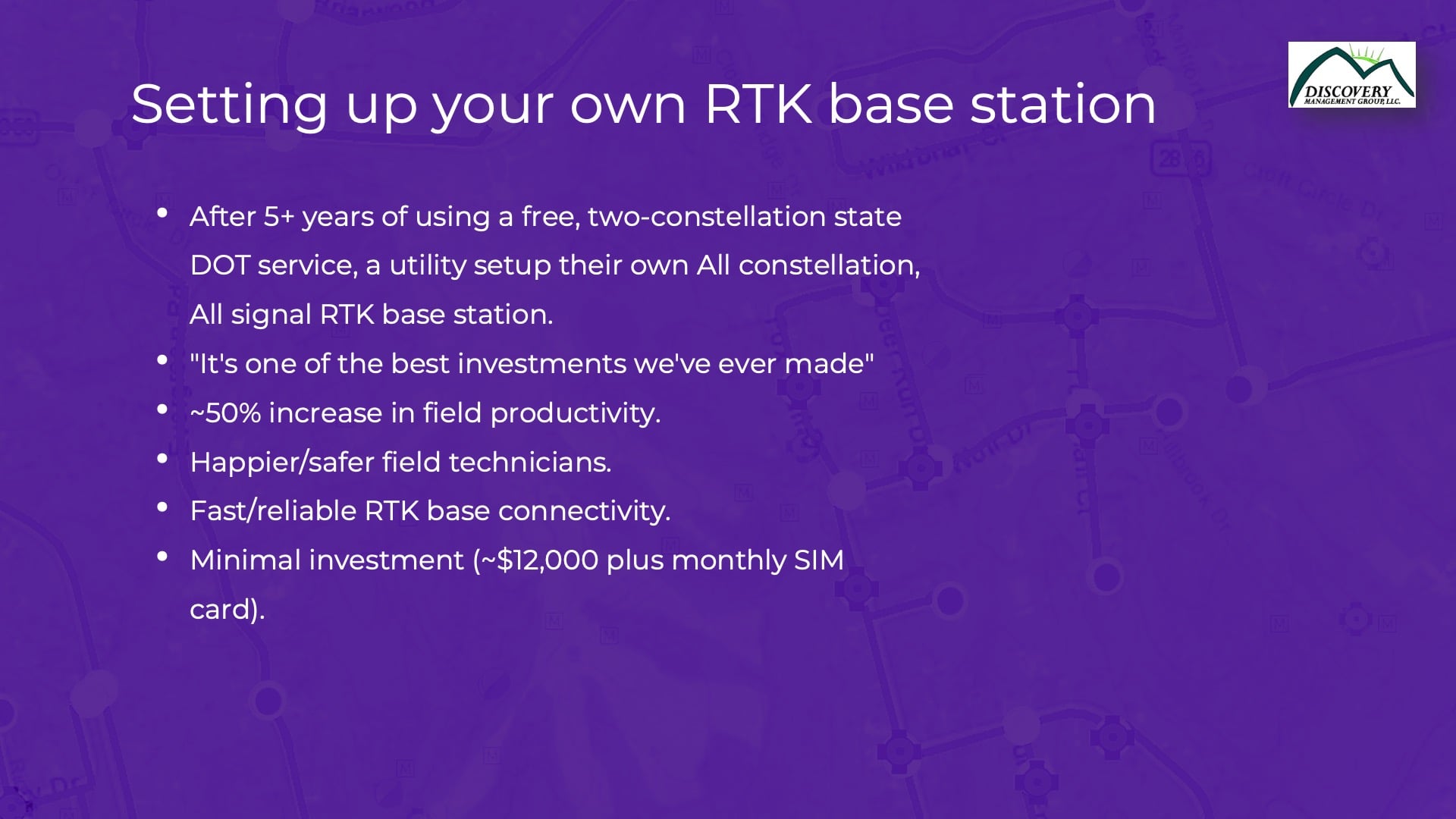
There’s certain states, probably about 20-25, that have their own free RTK systems, especially from their [department of transportation] DOT systems. I’ve used nearly all of them at one point or another. But we see some of the DOTs aren’t keeping up with the latest technology. I’m not blaming them because doing so is expensive. But a lot of these DOT RTK systems are still broadcasting a subset of the four constellations, either two or three constellations. So even in areas with these free DOT RTK networks, we still have a lot of customers establishing their own base stations.
Missouri is a great example. I’m not going to pick on Missourians, but we’ve done quite bit down there. Where they support only two constellations, we’ve installed base stations. And the users have said, “Hey, we’ve been using MDOT’s base station for four years now. And the difference between having our own base station now is amazing in the field.”
You’re talking about a 50% increase in productivity when using RTK, just from changing to a four-constellation base station from a two-constellation one.
Setting up a base station is not as expensive as it used to be, either. It used to be a $50,000 endeavor, with high maintenance. Now, you can install one for $12,000 and then have no maintenance afterward. They’re really maintenance free these days. The Missouri customer provided this quote; they said, “It’s one of the best investments we’ve ever made.”
We’ve installed hundreds of these faster, reliable, four-constellation RTK base stations all across the U.S.
What is a Base Station, Actually?
I talk about base stations a lot, and people say, “Well, what’s that?” It’s sort of an archaic term. So this is actually what a base station looks like on the screen.
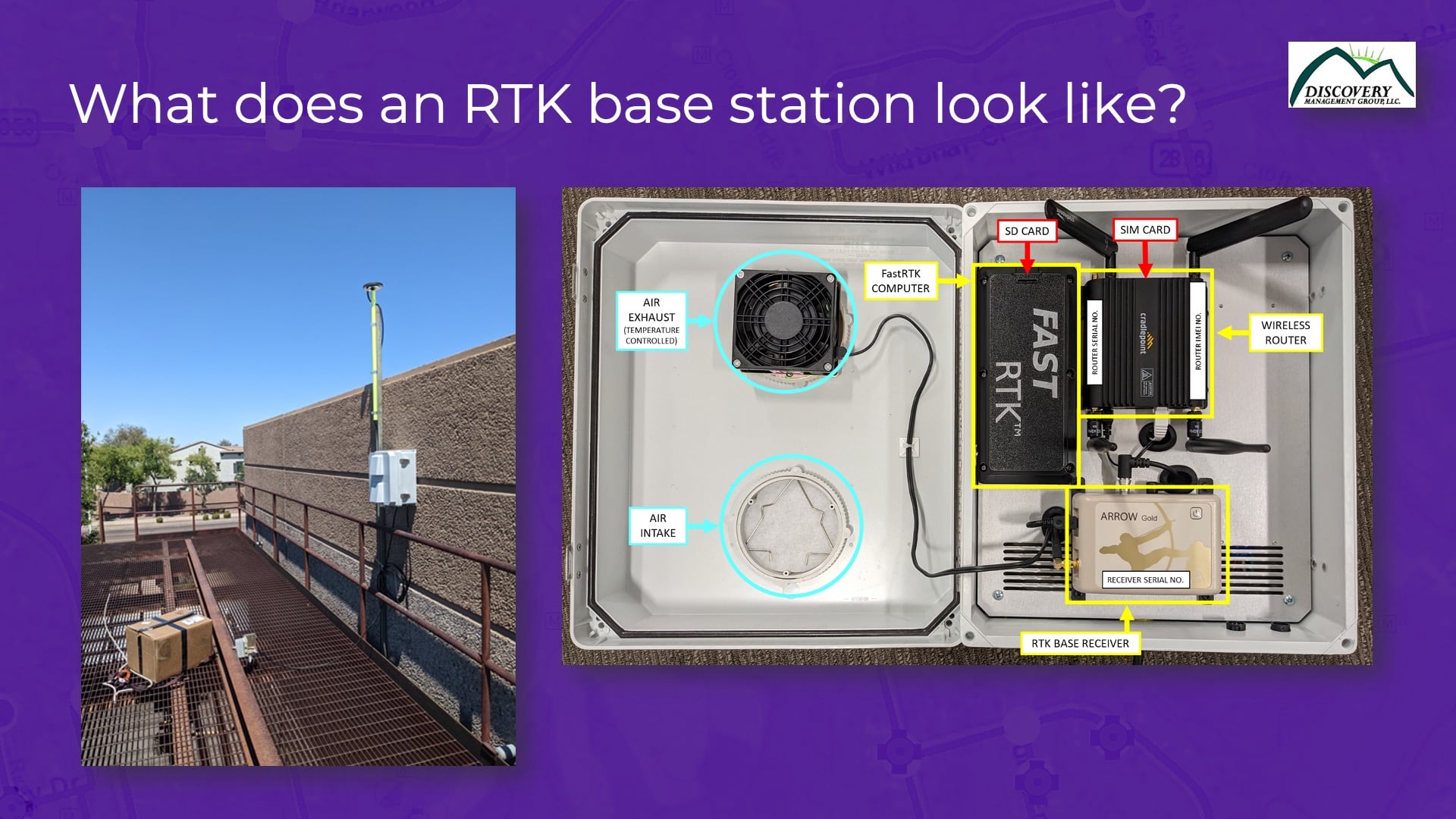
It’s just a weather-proof box, tacked onto the side of a building roof, with the antenna bolted to the wall. This particular one has got a Verizon wireless router on the right side of the screen. You see this base station has got an Eos receiver as its GNSS brain. And then up above that is a SIM card modem. That just means you stick in a SIM card from AT&T, T-Mobile, or whomever. It doesn’t matter what SIM card you use. And all your Internet connectivity is done via that SIM card. The base station operates completely separate from corporate networks. You don’t have to get IT involved, in that respect, or get their approval. There are no vulnerabilities. No one’s going to hack into this.
That’s all it looks like. It’s pretty straightforward. Once they’re fired up and running, they just work. We don’t have to do any maintenance at all. You just need to maintain a supply of power, that’s the key thing.
Well that was my last slide. Great — thanks! I guess we’ll go to Jean-Yves.
[audience applause]
What’s New in High-Accuracy GNSS?
JEAN-YVES: Thank you, Eric. I’m going to talk a little bit more about Galileo HAS. Almost two years ago, we came out with the Arrow Gold+ receiver in anticipation of the Galileo E6 signal. It was there, waiting for the system to be ready. We’ve been in talks with the European Union Agency for the Space Programme (EUSPA) for a long time.
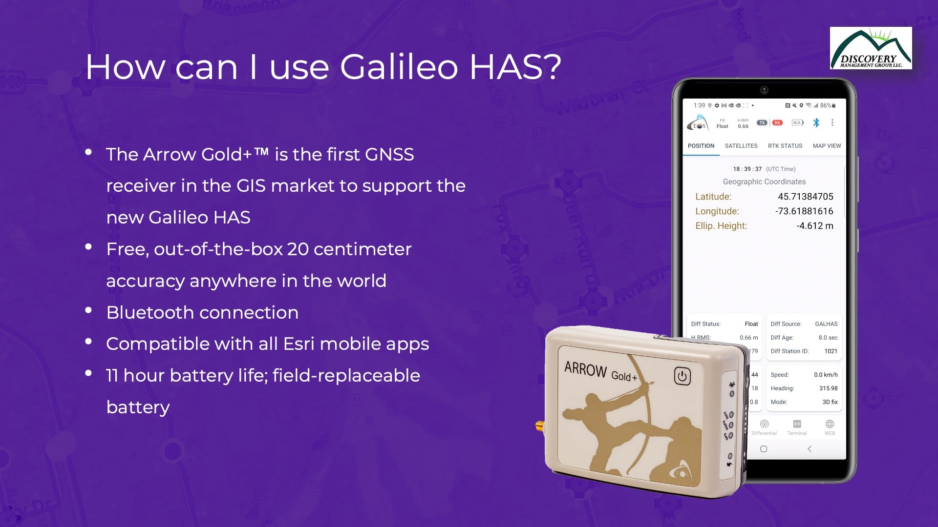
When Galileo HAS came out, which was in January of this year, the E.U. organizations released Phase 1. It actually went from Phase 0 to Phase 1. Phase 0 was for visibility, but Phase 1 serves as the beta phase, where they have users test it. They want to fine tune the system before it goes to the final phase, of course, which is Phase 2. So, immediately when Phase 1 became available this year, we updated firmware immediately, released beta testers in the field, and promoted to our user base that this was now an option in beta.
EUSPA saw our promotion and said, “Hey, we need you for the Galileo HAS Days inaugural event.” That conference was two weeks ago in Madrid, and they wanted us to present our results from testing Galileo HAS around the world. They also wanted to hear from us what the mapping community wants from Galileo HAS and the benefits we are starting to see them get from such a signal. So, I was invited there in Madrid to speak, and I went there and learned a lot, which I’m going to share with you.
How Does Galileo HAS Work?
Basically, I just want to do a quick overview of how the Galileo system works. The HAS service uses a different form of corrections than you guys are familiar with. It’s called PPP corrections. It’s different from the local corrections that you get from an RTK network or an RTK base station, in which you connect to the base, receive the corrections, and have immediate results.
What is PPP?
When using PPP, there’s no base station around you. This model uses different types of information. It uses a clock corrections, actually; these are the satellite-orbit corrections. It uses cold biases or phase biases. (Also, don’t worry if you don’t understand, I am still understanding myself too.) And it uses basic atmospheric corrections. So basically, these are global corrections that are not really conventional. PPP was put in place by Natural Resources Canada back in the 1980s, and now people are increasingly using PPP.
So, PPP has some advantage: There are no base stations, for instance. But it also has a disadvantage: And that is, you’ll have to accept a little time for convergence. At a very high level, it basically has to do a whole bunch of mathematics before it can converge to a good solution. So, it takes some time. Eric shared some results on what convergence times and accuracy levels he’s experiencing. We are told this will improve in Phase 2.
Architecture of Galileo HAS PPP
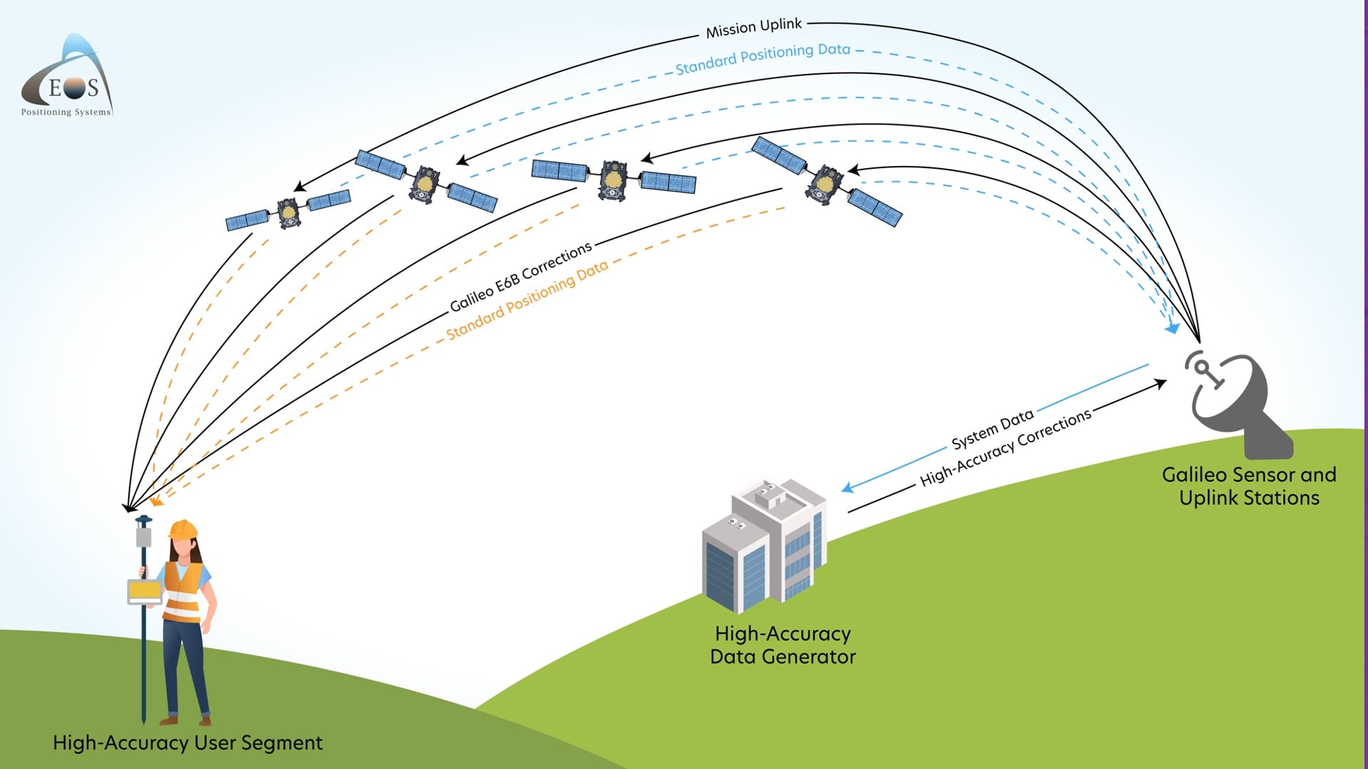
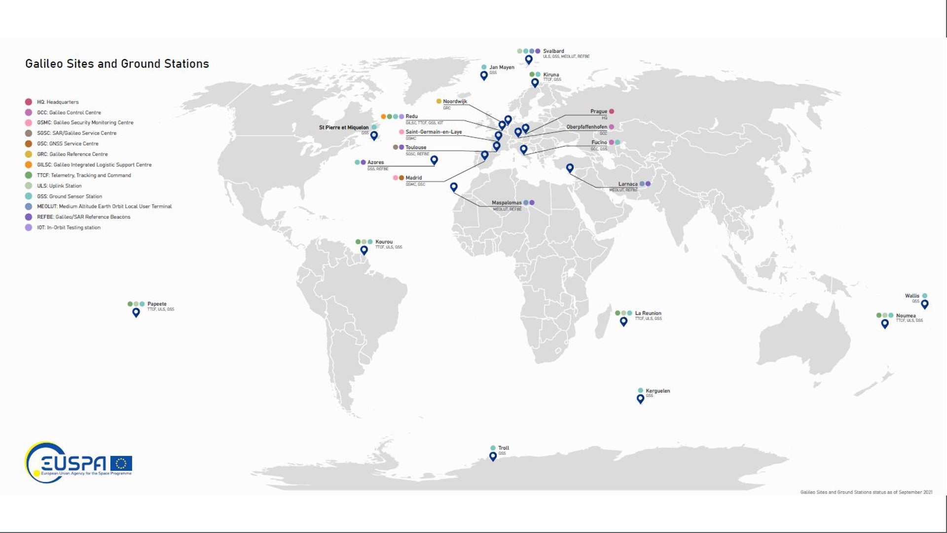
The way the architecture of the system works is this: You’ve got satellites in space. You’ve got monitoring stations around the world on the ground monitoring the Galileo satellites. The monitoring stations are computing a lot of different inputs and observations, pushing these to a central station, processing everything in Madrid, and after that, pushing out the results back to the Galileo GNSS satellites themselves, so they can broadcast those messages directly to compatible GNSS receivers. And the beauty is that each Galileo satellite participates in the overall message. Each one sends out bits and pieces of the message, every second. So even if you’re lacking some satellites, you will receive some information from the other ones and get a good convergence. That model is called a signal in space (SIS). There is another model, known as data description over the internet (DDI), but I don’t really see any of our users exploiting that for GIS applications. It’s a bit more complicated because even if you have a compatible receiver and reliable Internet connectivity, you’re still going to receive corrections in something other than the same format as standard RTCM that you probably already know of. It is RTCM, but they have different messages that are for PPP corrections specifically. All of that is to say, signal in space or SIS is really what we want. So we won’t pay attention to the DDI option now.
Galileo HAS Phases
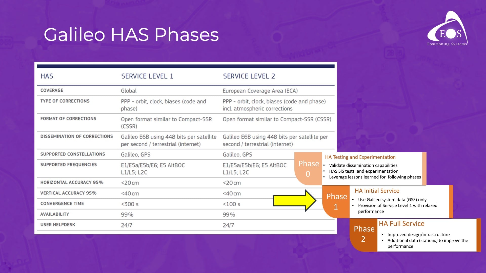
So here are the phases of Galileo HAS. Phase 0 is over. We’re in Phase 1, or beta. Phase 2 will come in the future. They are try to release Phase 2 as fast as they can, but I think we’re about at least 1-2 years away from that. In the meantime, Galileo HAS beta works. They’re fixing a couple of bugs, data gaps, etc. They are also working to increase the number of monitoring stations around the world. All of this will get the system ready for Phase 2. There’s a lot of work they doing and going to be doing in this coming year, so we are sure to see improvements.
When we get to Phase 2, that’s when Galileo HAS is going to be declared basically operational. When we’re in the operational phase, you’ll want to know that we have two levels of service. There’s basically one service level for Europe, which is going to call itself Service Level 1. With Service Level 1 in Europe, your convergence time will be less than 100 seconds. So inside of two minutes, you’ll be up and running with 10 to 15 centimeter accuracy, or about 3-4 inches. Now Service Level 2 will be for the rest of the world. With Service Level 2, you’re going to have about a five-minute convergence time; that’s simply because there are fewer monitoring stations around the world outside of Europe, which makes sense since this is a system developed by the E.U. But within just five minutes, you will go down to within 10 to 15 centimeters. So that’s how the system is designed and planned, and this is what will happen in Phase 2.
Galileo HAS Uses Multiple GPS and Galileo Frequencies
Galileo HAS uses corrections for GPS and Galileo constellations over multiple frequencies. Initially, it was supposed to use only L1, L5 GPS. But then it was a big surprise to me to see that they’re actually supporting L1, L2 and L5. L5 GPS don’t have enough satellites in the modernization of GPS. There are, what, 15 or 16 satellites out of 31 that need to be modernized, but that is going to come soon. For L2, they didn’t even go to L2C yet (the second generation of civilian GPS signals). They’re still with L2. The new civilian signal is going to get even more satellites also, and then it will transition to the new L2C signal, which is very good. So, triple frequency for GPS. There’s no plan for Galileo HAS to support GLONASS and BeiDou in their systems. It’s going to be a dual-constellation solution, if you want to think of it that way.
Very Promising Initial Results: Eos Tests Galileo HAS with the Arrow Gold+ GNSS Receiver
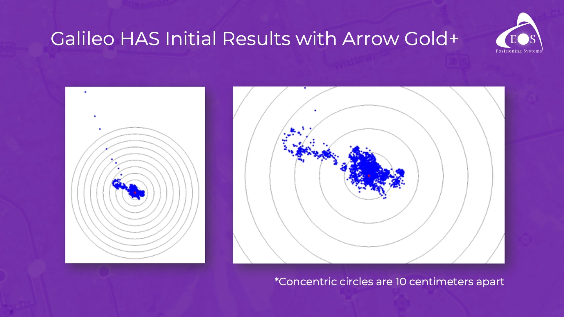
Initially, I did a quick series of tests like Eric did in Oregon. We have a roof in our headquarters in Montreal, and basically I logged data for 18 hours. I was surprised to see the results. It took a while to get to the full level of accuracy. That was expected, because no phase bias is currently being broadcast. (It will be broadcast later this year.) As a result, we know our conversion takes longer right now. But after, I would say, less than an hour, we were getting within the 20-centimeter range. The following day, I came back to the office after about 18 hours and looked at the results again. The average accuracy was about two to three inches. I wasn’t expecting that! This was the very first test I did.
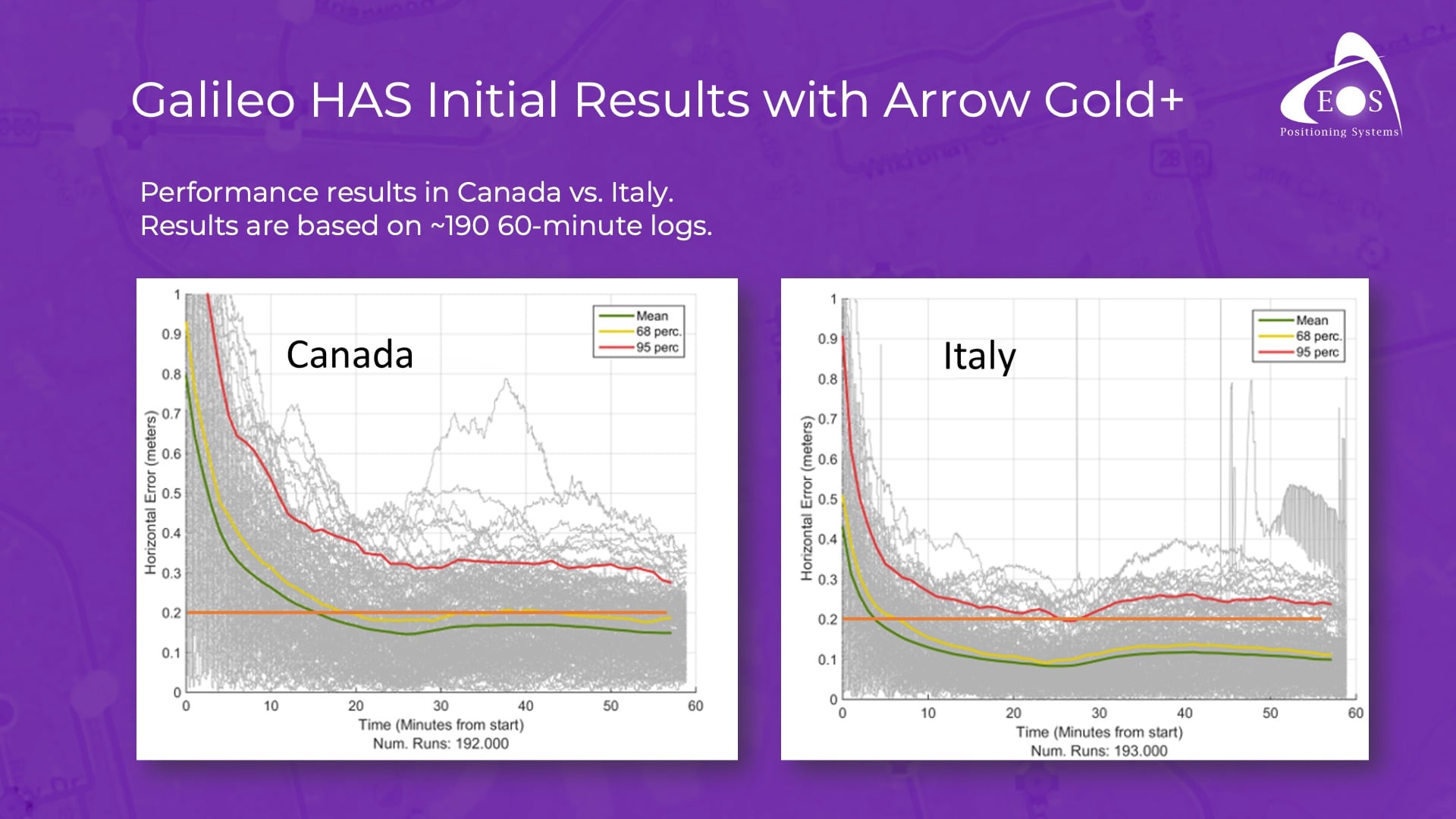
We decided to expand testing. In Europe and Canada, we did some additional logging. What you see here are 190 test runs of one hour each. Now you can see that in Europe, we go down to about 30 centimeters within 5 minutes — even in just the Phase 1 beta. And this will get better with time. In Canada, it took us about roughly 20 minutes to go to the foot-level of accuracy. But then after that, it got even better with time. So this is currently the difference between Europe and the rest of the world, and our test results align with what we would expect based on the communications from EUSPA. We know that for the next two years, their work is going to be to add stations all over the world in order to decrease this convergence time.
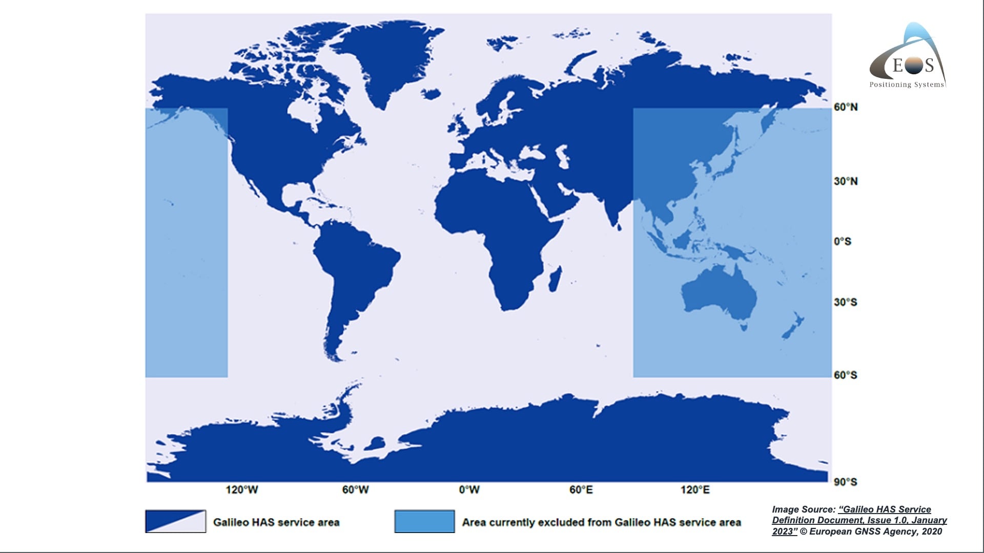
Looking elsewhere globally, you’ll notice here that for the area over Asia and Australia there is a gap shown on this map. That doesn’t mean you cannot use Galileo HAS in Australia. It just shows that because of the lack of ground stations there today, your convergence time might take a bit longer than what we’ve seen elsewhere, before you can subfoot accuracy.
Early Users Adopting Galileo HAS Today with the Arrow Gold+
The beauty of Galileo HAS is truly that you can start using it right now. Those of you who have the Arrow Gold+ receivers — because you do need special Arrow Gold+ antenna which supports the E6 frequency, to support all those signals — you can use Galileo HAS today for free. We have beta firmware that you need to request for free, and we’ll show you how to update your receiver and start using it in the field. Then you can decide: When you want to use RTK, you connect to RTK. If you’re in a remote area, then you will transition seamlessly to Galileo HAS.
One of our very first adopters was the National Park Service (NPS). They have a few hundred of those Gold+ receivers, so they have started using Galileo HAS in the field and giving us feedback. When I presented that to EUSPA, they were astonished by this. They couldn’t believe that people in the mapping community outside of Europe were waiting for them! I got almost a standing ovation when I was there, thanks to you guys here doing the work you do.
Galileo HAS will get better as the months go by, into next year. But we encourage you to try it today and give us your feedback. Let it run when you are getting set up to go into the field. Unload the receiver from your truck, leave it somewhere to converge, do your preparation work, and then 10 to 15 minutes later pick it up and start doing your field work. You will likely have subfoot accuracy with that.
Now, there’s a lot of work that we will be doing to continue tuning this firmware over time. So those of you who are interested in the testing, please do. It is free today, and we will support you.
I want to thank you all for being present.
[audience applause]

![What’s New in High-Accuracy GPS/GNSS for GIS Users [A 2023 Esri UC Session]](https://eos-gnss.com/wp-content/uploads/2023/07/Whats-New-in-High-Accuracy-GPS_GNSS-for-GIS-Users-A-2023-Esri-UC-Session.jpg)