
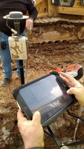
Tucked into the mountains of Kentucky and bordered by the Ohio River, the Oldham County Water District (OCWD) serves 8,317 customers annually.
In 2001, OCWD created the first electronic maps representing its water system. In 2016, with a short-term goal to improve the operational efficiency of its field workflows and a longer-term goal of creating a highly accurate system of record that would serve its constituents well into the future, the OCWD explored technology advancements that could replace its costly, time-consuming field workflows.
“Installing each meter used to cost us approximately $211.91 in labor and fuel,” said Kenny Ratliff, OCWD GIS Manager. “With the high-accuracy mobile GIS workflow, the cost per meter went down to $111.19.”
Read how OCWD arrived at an affordable, mobile GIS solution for its rural water system in the Eos February 2018 Issue article. Dive into the full success story: “Kentucky Water District Cuts Meter Installation Costs in Half with High-Accuracy, Real-Time Data Collection.”
Industry Updates from the Eos February 2018 Issue:
- [News] Constellation Completed: Two satellites have joined the Quasi-Zenith constellation, completing it. Read the GPSWorld article.
- [Webinar] Mobile GIS Workflows: Did you miss the 1-hour webinar from Eos and Esri Canada, “Mobile Apps in the Collaborative ArcGIS Platform”? View the 1-hour recording (webinar is in French).
- [Webinar] Improve Data Quality: Learn how to improve data quality related to utilities and other infrastructure-based industries in this 1-hour webinar from Esri U.K. and Eos U.K. distributor MGISS.
- [Podcast] Collaboration in Kentucky: See how utilities in Kentucky are sharing GIS data to reduce road cuts on the latest podcast episode of Kurt Towler’s Speaking of GIS — the newest podcast about GIS, and the people who make it happen.
Al’s Corner | Technical Tips from Eos:

Hi… My name is Alvaro and I am the Technical Support Manager at Eos Positioning Systems. I am inviting you to visit our Learning Center on our web site for useful technical information, how-to’s and video tutorials. This section will be updated regularly with new material. Any question? please do not hesitate to contact our technical support center.
- [Firmware Update] European and North African Users: A firmware update is available for the Arrow 100. This update supports the new EGNOS satellite constellation. Request instructions to receive the update by filling out the Eos support contact form.
- [Download] Eos Tools Pro v1.66 for iOS®: A new version of the app is available for download on the Apple Store. Version 1.66 now features save-able NTrip profiles, enhanced interface for datum shift/offset, and automatic re-connection to RTK stream after loss of Internet connectivity. A new Android version will be available soon.
- [Watch] ArcGIS Collector Webinar: Get started with ArcGIS Collector with these tips, tricks, and best-practice workflow breakdowns from Esri Product Manager Jeff Shaner. Learn how to create web maps and more.
How-To Guide:
Enabling Mock Location on Android for Eos Tools Pro
Learn how to setup “Mock Location” on your Android device for use with the Eos Tools Pro app.
Video Tutorial:
Configuring Esri ArcGIS Collector with Arrow on Android
