Eos Positioning Systems

Tel.: +1 (450) 824-3325 (CAN)
  • Technical Support
  • EnglishEnglish
    • Français Français
    • Español Español
  • Home
    • About
    • Contact
    • Technical Support
    • Subscribe
    • Testimonials
    • Users
  • Products
    • Arrow Series™
      • Arrow Gold
      • Arrow 200
      • Arrow 100
      • Arrow Lite
      • Comparison Chart
    • Accessories
      • Antennas
      • Mounting Equipment
      • Extra Battery & Power
      • Field Gear
      • Atlas® Service
    • Tools and Apps
      • Eos Tools Pro
      • Eos GNSS Tools
      • Eos Utility
      • Eos Server
      • Arrow USB Drivers
    • Solutions
      • Geoid Height
      • Eos Locate™ for ArcGIS Apps
      • Eos Laser Mapping for ArcGIS Apps
  • News
    • Latest News
    • Success Stories
    • Events
    • Newsletter
    • Press Releases
    • Blog
  • Learning Center
    • Arrow
      • How-To Articles and PDFs
      • Video Tutorials
      • Arrow Datasheets (PDFs)
      • Manuals (PDFs)
    • GNSS
      • GNSS Articles
      • iOS and Bluetooth®
  • Partners
    • Field Apps
      • Esri
      • AmigoCloud
      • CartoPac®
      • Corvallis Microtechnology (CMT)
      • DigiTerra
      • Futura
      • GeoMobile Innovations
      • GI Geoinformatik GmbH
      • mapitGIS
      • SPOT
      • SST Software
      • TAXUS IT
      • TerraGo
    • Hardware
      • iOS
      • Android
      • Windows
      • Laser Technology
      • Tablet EX Gear
CONTACT
  • Home
  • News
  • Latest News
  • Arrow Gold for Field Staking: TCEC Improves Customer Service with Real-Time ArcGIS Access via Futura GIS

Arrow Gold for Field Staking: TCEC Improves Customer Service with Real-Time ArcGIS Access via Futura GIS

by Eos Positioning Systems / Tuesday, 11 June 2019 / Published in Latest News, News, Success Stories
Arrow Gold for Field Staking: TCEC Improves Customer Service with Real-Time ArcGIS Access via Futura GIS; Eos Positioning Systems case study - TRI COUNTY ELECTRIC COOPERATIVE TCEC in TEXAS uses Eos Arrow Gold and Arrow 200 for field staking of electric construction sites with Futura Systems' FieldPro staking app on iOS; shown here is part of the TCEC team performing field staking
TCEC wanted to improve a time-consuming, legacy field-staking workflow, which made it difficult to provide new members with updates about construction.

The migration to an enterprise Futura GIS with high-accuracy location from Eos Arrow Gold GNSS receivers yielded tens of thousands of dollars saved each month from improvements to field staking, outage management and underground locate workflows.

The Organization: Tri-County Electric Cooperative

With a 4% annual growth rate based on new meters installed and serviced, construction at Tri-County Electric Cooperative (TCEC) has been booming. The north-central Texas co-op is adding approximately 4,000 new members per year.

“Commercial growth moved into the area, which led to residential growth,” TCEC CTO Nichole Eshbaugh said.

Arrow Gold for Field Staking: TCEC Improves Customer Service with Real-Time ArcGIS Access via Futura GIS; Eos Positioning Systems case study - TRI COUNTY ELECTRIC COOPERATIVE TCEC in TEXAS logo
VISIT TCEC

The Challenge: Explosive Growth, but Paper Oriented

Expanding rapidly, TCEC wanted to improve construction visibility for new members by consolidating to an enterprise GIS with real-time field staking.

In order to improve its competitive edge, TCEC revisited its already excellent customer service. One of the areas that could be improved was a time-consuming field-staking workflow, which made it difficult to provide new members with updates about construction. The legacy workflow relied on hand-drawn stakeout maps and standalone GPS points, which were manually integrated into a legacy asset management system.

Posting as-builts to the GIS used to take 10 months.

“It was a bulky, manual analog process to integrate the GPS shots into the mapping system along with paper drawings, and then send it to the mapping department,” Enterprise Manager Glenn Williams said.

Answering customer inquiries was also difficult. “It was very hard to tell the member where we were with that job,” Eshbaugh said. “You just hoped the right person was around.”

Arrow Gold for Field Staking: TCEC Improves Customer Service with Real-Time ArcGIS Access via Futura GIS; Eos Positioning Systems case study - TRI COUNTY ELECTRIC COOPERATIVE TCEC in TEXAS uses Eos Arrow Gold and Arrow 200 for field staking of electric construction sites with Futura Systems' FieldPro staking app on iOS; shown here is FieldPro on iPad from a real project
TCEC wanted a real-time, user-friendly, field-staking solution. They wanted the new workflow to provide real-time GIS updates to field crews. Shown here is Futura's FieldPro iOS app as it consumes data from many sources in real time: Live GIS data from TCEC's enterprise Futura-Esri GIS. And live RTK GNSS data for high-accuracy location from an Eos Arrow RTK GNSS receiver.

The Solution: Futura Enterprise GIS with FieldPro, Eos Arrow Gold GNSS Receivers

“We did our due diligence in researching the Eos Arrow GNSS receivers. What it came down to was their ease of use with Futura’s FieldPro mobile app and their dedicated customer support.”

— Nichole Eshbaugh, CTO, Tri-County Electric Cooperative

First and foremost, TCEC wanted to replace its siloed legacy workflow, including the paper data collection, standalone GPS shots, and disjointed systems for asset management, customer information (CIS), outage management (OMS) and billing.

“We didn’t want to have siloed information anymore, and we didn’t want to have to chase vendors about integrations,” TCEC Field Services Director Kevin Mooney said. “More than anything, we leaned toward being an enterprise shop.”

They selected Futura Systems’ enterprise GIS for several reasons. First, Futura provided user-friendly asset and outage management interfaces for their underlying Esri ArcGIS geodatabase. It also integrated out-of-the-box with their existing billing system (ATS) and call center system (Centurion IBM). Finally, the FieldPro iOS app supported high-accuracy, real-time staking updates.

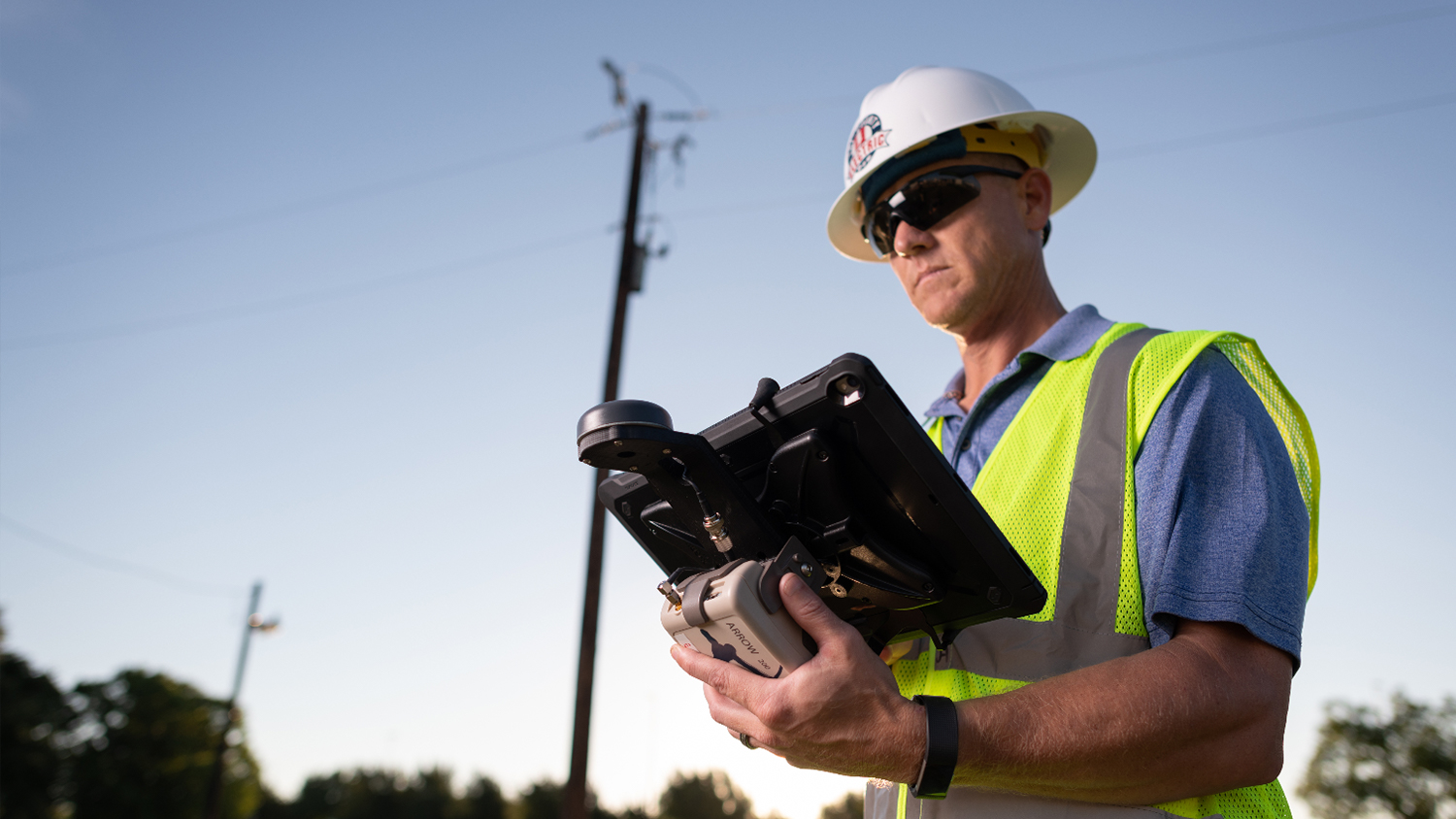
TCEC explored multiple external GPS receivers to pair with FieldPro and to eliminate the manual entry of  GPS coordinates. Location accuracy was especially important for capturing underground as-builts.

“Overhead assets are easy to see, but for underground you need higher accuracy,” Mooney said. “In some of our heavily populated areas, up to 75% of our assets can be underground.”

After researching FieldPro-supported high-accuracy GPS receivers and consulting internal staff familiar with the GPS technology, TCEC chose the Eos Arrow Gold RTK GNSS receiver.

“It really came down to the positive customer support we received from Eos,” Mooney said.

Arrow Gold for Field Staking: TCEC Improves Customer Service with Real-Time ArcGIS Access via Futura GIS; Eos Positioning Systems case study - TRI COUNTY ELECTRIC COOPERATIVE TCEC in TEXAS uses Eos Arrow Gold and Arrow 200 for field staking of electric construction sites with Futura Systems' FieldPro staking app on iOS; shown here is part of the TCEC team performing field staking
TCEC selected Futura Systems’ enterprise GIS because of its friendly UI tools, COTS integrations, and FieldPro iOS app for real-time staking. FieldPro also supported the Arrow GNSS receiver.
LOGO - FUTURA SYSTEMS

Futura Systems, Inc., is a leading provider of enterprise GIS and asset management for utilities. Their popular desktop and mobile solutions include tools for mapping, asset management, work order management, outage management, and the FieldPro iOS app for real-time staking. Learn how Arrow works with FieldPro.

EXPLORE THE ARROW GOLD RTK GNSS RECEIVER

The Results: Seamless, Real-Time Locates in Congested Facilities

“We do about 25% to 35% fewer truck rollouts for our locates now. At $10 a ticket and 13,000 tickets per month, that’s a lot of savings.”

— Glenn Williams, Enterprise Manager, TCEC

After just three months, the migration to Futura was complete. TCEC also deployed FieldPro and Arrow receivers to 11 trucks with iPads. Today, nearly all of TCEC’s 172 employees access asset information in real-time from the enterprise system.

“We started with a little reluctance, not sure what the future would bring, but everything being combined has been a huge success,” Williams said. “Our stakers, operations groups – everyone is using the Futura system.”

The time needed to post as-builts from the field to the GIS went from 10 months to less than four hours, in most cases.

“Now we can instantaneously retrieve projects and answer customer questions,” Williams said. “The convenience is huge.”

Additional Results

Outage management and underground-locate workflows have also benefited from the implementation of the new system. The co-op estimates it is saving about $32,500 per month, thanks to fewer physical digs and truck rollouts required for underground locates for 811. This year, TCEC’s locate bill dropped “big time”, and so did liabilities.

“We do about 25% to 35% fewer truck rollouts,” Williams said. “At $10 a ticket and 13,000 tickets per month, that’s a lot of savings.”

Now, TCEC will pass on those savings to members, who have also benefited from faster power-outage response and communication.

Customers can report outages using TCEC’s website and mobile app, or they can call in and talk to technicians who update internal web maps on Futura Catalyst. In addition, dispatchers and line workers can also access live outage data in the field at any time of day, even at 2 a.m. while fixing lines, via the Futura interface.

In early 2019, TCEC put the enterprise OMS to the test when a powerful wind storm left a large swath of customers out of power.

“We got it under control, and the staff rolled through with no problems,” Eshbaugh said. “Our outages are managed with a lot fewer people and a lot less chaos.”

Last year, the average interruption index for members involved in an outage was 66.5 minutes. TCEC expects this number to improve. They also plan on tracking, communicating, and passing on any additional savings and service improvements to customers.

“In the end, knowing where our assets are improves the service we provide to our members,” Williams said. “We keep the lights on better.”

Arrow Gold for Field Staking: TCEC Improves Customer Service with Real-Time ArcGIS Access via Futura GIS; Eos Positioning Systems case study - TRI COUNTY ELECTRIC COOPERATIVE TCEC in TEXAS uses Eos Arrow Gold and Arrow 200 for field staking of electric construction sites with Futura Systems' FieldPro staking app on iOS; shown here is part of the TCEC team performing field staking
TCEC deployed iPads with FieldPro and Arrow GNSS receivers to 11 trucks. Today, nearly all of TCEC’s 172 employees access asset information in real-time from the enterprise system.
Eos Positioning Systems case study - TRI COUNTY ELECTRIC COOPERATIVE TCEC in TEXAS uses Eos Arrow Gold and Arrow 200 for field staking of electric construction sites with Futura Systems' FieldPro staking app on iOS; shown here is a Futura Catalyst project screenshot
The time needed to post as-builts from the field to the Esri GIS went from 10 months to less than four hours with the new Futura/Eos/iPad solution.
Eos Positioning Systems case study - TRI COUNTY ELECTRIC COOPERATIVE TCEC in TEXAS uses Eos Arrow Gold and Arrow 200 for field staking of electric construction sites with Futura Systems' FieldPro staking app on iOS; shown here is a Futura Catalyst project screenshot
“Now we can instantaneously retrieve projects and answer customer questions,” TCEC Enterprise Manager, Glenn Williams said. “The convenience is huge.”
LEARN MORE ABOUT THE ARROW GOLD
Download Article as PDF
Click to Download

More Eos news:

Zachary Zac Petix, Palmetto Engineering, Esri partner, Eos Positioning Systems Arrow GNSS receivers customer spotlight
02/03/2021
Customer Spotlight: Zac Petix, the Sherlock Holmes of High-Accuracy GIS
READ MORE
Vermont Gas 9 Taking a point side of road utility Arrow Gold ArcGIS Collector
01/03/2021
Vermont Gas Systems Doubles Efficiency with Arrow Golds and iPads
READ MORE
Customer Spotlight David Gigliotti 1080x1920 pipeline route delineation open source GPS to Arrow GNSS ArcGIS
16/02/2021
Customer Spotlight: David Gigliotti Sees Projects Come to Life with a new GPS system
READ MORE
DDS Companies Presentation Feature Image
12/01/2021
Real-Time, High-Accuracy Data Collection Drastically Reduces Labor Associated with Fieldwork at The DDS Companies
READ MORE
Ben Griffith of Texian Geospatial receives differential corrections from an Arrow Gold base station in real time, allowing him to capture the location of a fire hydrant valve within several centimeters of accuracy using ArcGIS Collector.
03/12/2020
Arrow Gold for Rural Water: Mapping a Rural Water System with High Accuracy
READ MORE
Feature Image - Eos Locate Case Study
30/11/2020
Eos Locate for Underground Mapping at Oakland County, Michigan (2020 MiCAMP Presentation)
READ MORE
LEARN MORE ABOUT THE ARROW GOLD
Tagged under: Arrow Gold, Co-Operative, Construction, Electric, Field Staking, Futura, Utilities

About Eos Positioning Systems

Our technical team pioneered the BYOD (Bring Your Own Device) high-precision Bluetooth GPS / GNSS market more than a decade ago when they designed the SXBlue product line. In early 2014, this same team founded Eos Positioning Systems® to design the next generation high-performance Bluetooth receivers, the Arrow Series, which includes the world’s first Apple approved iOS RTK GNSS receiver capable of real-time centimeter accuracy, the Arrow 200.

NEED TECHNICAL SUPPORT?

Contact support now >

Search

Categories

  • Arrow Series™
  • Blog
  • Bluetooth
  • Firmware
  • GIS Articles
  • GNSS Articles
  • How-To Articles
  • News
    • Event Archive
    • Latest News
    • Success Stories
  • Newsletters
  • Press Release
  • Sessions
  • Technical Bulletin
  • Video Tutorials
  • Webinar

Archives

Twitter

Tweets by EosGNSS
Follow @EOSGnss

CONTACT

Eos Positioning Systems®, Inc. (Eos)

1160 Rue Lévis, Suite 100
Terrebonne QC, J6W 5S6
Canada

call-answer : +1 (450) 824-3325

M-F : 8:30 a.m. to 5:00 p.m. (ET)

Follow Eos:

SITE MENU

  • Home
    • About
    • Contact
    • Technical Support
    • Subscribe
    • Testimonials
    • Users
  • Products
    • Arrow Series™
    • Accessories
    • Tools and Apps
    • Solutions
  • News
    • Latest News
    • Success Stories
    • Events
    • Newsletter
    • Press Releases
    • Blog
  • Learning Center
    • Arrow
    • GNSS
  • Partners
    • Field Apps
    • Hardware

QUICK LINKS

  • Get Fast Technical Support
  • Contact Eos for Sales Inquiries
  • Subscribe to the Eos Newsletter
  • Compare Arrow GNSS Receivers
  • Find Partner Apps & Hardware

logo-standard-eos-blanc

Eos Positioning Systems © 2014 - 2020
Website designed and created by Backside Pixels

TOP