The Customer: City of Santa Barbara
The City of Santa Barbara, located roughly 90 miles north of Los Angeles, supplies water to approximately 95,000 residents. With California’s unique drought conditions, state water suppliers face challenges surrounding conservation, water-loss prevention, and system maintenance. The city wanted high-quality asset data to respond to fluctuating drought conditions.
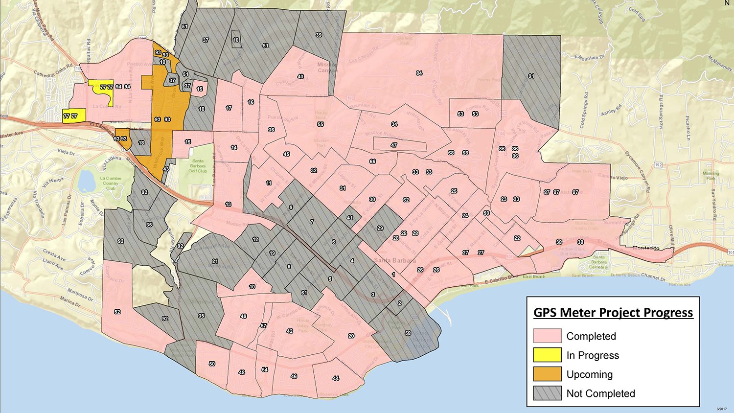
In 2014, Santa Barbara decided to optimize their water system by establishing a goal to replace all 27,500 water meters within five years.
”Instead of just doing a regular meter replacement based on age, we decided to handle this task comprehensively to set ourselves up for the future,” said Theresa Lancy, Water Distribution Supervisor at the City of Santa Barbara.
The Challenge: A Slow Legacy Field Data Collection Workflow
“In circumstances where multiple meters are located on a single parcel, knowing which meter was associated with a particular location was especially difficult.”
— Theresa Lancy, Water Distribution Supervisor at the City of Santa Barbara

While replacing water meters, the city wanted to collect the new meters’ locations with high accuracy.
In the past, the legacy mobile app they were using without a GPS did not allow them to locate individual meters. Meters were instead correlated with a parcel.
“We used the parcel number for a general idea of location,” Lancy said. “But in circumstances where multiple meters are located on a single parcel, knowing which meter was associated with a particular location was especially difficult.”
Since meters often sat within one foot of each other, Lancy’s team wanted a higher level of accuracy. As a proof of concept, they borrowed a GPS receiver from a sister department.
This equipment used a mobile base station to provide differential corrections, but the station needed to be manually set up and broken down on every trip. This took an hour of field work every day, slowing down the meter location collection. In 2018, the City of Santa Barbara looked for a faster data collection workflow.
The Solution: Moving to a Faster Field Data-Collection Workflow

Since they had the Esri platform, they chose ArcGIS Field Maps (formerly ArcGIS Collector) as their new mobile app. Field Maps established accuracy thresholds, while ArcGIS Online let multiple employees edit and utilize the updated web maps simultaneously.
The next step was to find a Field Maps-compatible GPS receiver. An employee suggested the Arrow Gold® GNSS from Esri business partner Eos Positioning Systems. The Arrow Gold® provided centimeter accuracy and was also compatible with iOS® devices the city already owned.
The only missing piece was the source of RTK corrections. Initially, they connected the Arrow Gold® to a base station 19 miles away. This base station was expected to provide centimeter-level accuracy, but it proved outdated and challenging to connect to.
Next, they instead opted to install another Arrow Gold® as a permanent base station on their distribution building roof.
“Because the cost and effort involved was fairly minimal, it just made a lot more sense to go ahead and set up our own base station,” Lancy said. “We also thought there could be other groups in the city that would use this system.”

The Results: Locating Meters Quickly and Efficiently

Since adopting the new solution, Santa Barbara has doubled its rate of meter-location collection.
Since adopting the new solution, Santa Barbara doubled its rate of meter-location collection. Field crews no longer spend an hour per day setting up and dismantling the temporary base station. Now, they are ahead of schedule for their initial goals.
Moreover, installed assets are recorded with centimeter accuracy with the Arrow Gold® and Field Maps, meaning individual meters formerly sharing a parcel can now be uniquely identified. The city has mapped 75% of their water meters. This information will be vital to future efforts to implement automated metering.
Customers have already benefited from faster repairs and increased water conservation.
2023 Update: 100% of the System is Mapped

In mid 2023, Eos Positioning Systems reached out to the City of Santa Barbara for an update. To date, the city has mapped 100% of its meters. They have also integrated this technology into new installations and emergency response. We thank City of Santa Barbara employees Andrew Benson, Maggi Heinrich and Hammurabi Days for their contributions to this story’s ongoing updates.
Download a PDF of this case study in ENGLISH.
You May Also Like One of These Success Stories

Mapping a Rural Texas Water System with High Accuracy
Rockett SUD streamlined field work and freed up office staff with a new rural water GNSS mapping solution that combines hardware and software from Eos and Esri.

Maine Consultancy Captures Water Infrastructure Data
Faced with a retiring workforce, Northern Forest clients began mapping assets. See how one consultancy helps them deploy Arrow 100 GNSS and ArcGIS.
