This past July, attendees of the 2024 Esri User Conference (Esri UC) joined Eos Positioning Systems® (Eos) for our annual “What’s New in High-Accuracy GNSS/GPS for Esri Users” hosted lunch. Industry leaders, including speakers from Eos and Esri, provided comprehensive overviews of the latest line of Eos GNSS receivers, The Skadi Series™; advancements in the GNSS industry; and the latest updates for ArcGIS® Field Maps.
This content-packed session covered several key topics, including:
- The brand-new release of the Skadi Series line of GNSS receivers from Eos
- Patented Skadi Series features such as Skadi Tilt Compensation™ and the Skadi Smart Handle™
- The evolution of high-accuracy mobile mapping
- Updates and roadmap for ArcGIS Field Maps
Watch the session recording below, or scroll through the transcript to find a specific topic …
Watch the 2024 Esri UC Session: “What’s New in High-Accuracy GNSS/GPS for Esri Users?”
Read the Session Transcript:

Introduction
SARAH ALBAN [Eos]: Welcome, everyone, and thank you for spending your lunch today with Eos Positioning Systems and our special guests. We’re very glad to have you here. If you haven’t gotten lunch or a drink, they’re in the back. My name is Sarah Alban. I’m the Director of Marketing for Eos, and we have some very exciting things to share with you this year.
Session Speakers

We’re going to have three speakers. To kick us off is Jean-Yves Lauture. He is the CTO of Eos Positioning Systems. He’s actually credited with creating the first Bluetooth® GPS receiver that could provide submeter and centimeter-level accuracy to any iOS®, Android™ or Windows® device.
Jean-Yves is going to talk about what’s new in GNSS from Eos Positioning Systems. And again, we’ve got some exciting things this year.
After Jean-Yves, we’re going to have Eric Gakstatter. Eric is the Principal GNSS Consultant at Discovery Management Group. He’s worked in high-accuracy GNSS for over 30 years. His company deploys thousands of GNSS receivers each year. And Eric is going to talk about the value propositions of the brand-new Eos GNSS receivers.
And then finally, last but not least, we’re having Jeff Shaner speak. Jeff is the Product Engineering Director for Esri ArcGIS Field Apps. With over 29 years of experience building software products at Esri, Jeff is focused on creating mobile solutions that simplify and improve the day-to-day operations of mobile workforces. Jeff is going to talk about the latest developments in ArcGIS Field Maps.
And with that, I’ll pass to Jean-Yves.
JEAN-YVES LAUTURE [Eos]: Thank you, Sarah.
Introducing the Skadi Series
Good morning, everyone, and thank you for being here for this presentation.

We are going to talk mainly today about the launch of our new GNSS receiver series, the Skadi Series. Is it “Sk-AY-dee”? Is it “Sk-AH-dee”? Well, in the Norse where she comes from it’s called “Sk-AH-dee”. So, if you guys want to be fancy, “Sk-AH-dee”. Repeat, everyone. No, don’t do that. [audience laughter]

Who is Skadi? We’ll get back to that after. But, right now, let’s just say that she builds on our old technology for the new receivers. But with additional features that add to it. We’ve listened over the years to our customers, seen what they want, seen what we’d like — and also what we think that they could use as new features that don’t exist yet in the industry or in the market. So that’s what the product is all about.
The Skadi Series Models

We have four models, just like the Arrow Series®. We start with Skadi 100™, which is a submeter model. If you are familiar with the Arrow 100® and Arrow Lite®, that’s similar to what it is — a single frequency [receiver]. You get your submeter accuracy and that’s the Skadi 100.
Then we have the lines of RTK receivers starting with the Skadi 200™, Skadi 300™ and the Skadi Gold™. The Skadi 200 is a dual-frequency receiver. The Skadi 300 is a triple-band receiver, and the Skadi Gold is the full-band receiver. It has everything that moves: all the signals, and it supports also Galileo E6. Galileo E6 which is still in phase one, but I got news two weeks ago from the EUSPA (European Union Agency for the Space Programme) that they were planning to go to phase two next year. So, everybody on the planet will be able to enjoy 10-to-20-centimeter accuracy with a reduced convergence time of five minutes. So, that is coming also next year. Stay tuned for announcements on the Galileo High Accuracy Service (Galileo HAS). So this is the line up of the Skadi Series. And to that, we added features.
Skadi Series Features: Shapeshifting in the Field

The first one I think that is new in the GIS industry is bringing tilt compensation to the product. So, there are new hardware features. What was needed was to be able to shapeshift in the field quickly. Some people like handheld setup, some people hate handheld setups, some people like a range pole, and some people hate the range pole.
So how can we please everybody with a product? That’s the challenge of the last three years in the making of this product. I can tell you. So, I think we came up finally with something good that could be interesting. Where you can seamlessly transition from a pole mount, remove it from the pole mount, put it on the Skadi Smart Handle, remove your battery pack. You have a hot swap battery in there to keep it alive for [shushing motion] 20 minutes, but let’s just say three minutes, so hurry up. The backup battery lasts long there, so it keeps it alive while you change your battery. You don’t lose your RTK. You don’t lose a satellite convergence. You put back your handheld, and put the battery back underneath it.
This is what the handheld setup would look like. Here I have an iPad®. You can shapeshift to the pole mount. Clip it quickly on the spring-loaded bracket, release your batteries, change it, put the battery in there, and you have your receiver on the pole and vice versa.
An integrated antenna is included inside the receiver, though you can plug in an external antenna with the product if you require one. Some applications require a vest, for instance, where you have the receiver on the front pouch. For example, in natural resources applications such as forestry mapping, you carry the receiver in your front pouch and have the antenna on the on a hat or on the shoulder: You can do that still by connecting an external antenna to the to the Skadi receiver.
There are two main features, again. The first one is using the receiver itself on a pole. The feature for this is called Skadi Tilt Compensation. We’ll talk a little bit about this afterwards. And then there is the handheld configuration.
Every receiver comes with a handle. But we call it the “dumb handle” (don’t say that too loud) because without the Skadi Smart Handle capabilities this standard handle does nothing except provide support for your phone or bracket. And it comes with brackets for your phone, the big one for iPad and iPad mini® and a small one for phones.
Why do we include two brackets? Because they were specifically designed so you can rotate your device easily to free your camera so you can take pictures and for use cases such as augmented reality, while you’re holding the receiver in your hand. So, we include two brackets and there is also support for standard brackets that you can find on the market. If you don’t like this one, you can put in your own, on the standard universal pole mount.
We also have a few features that we’re going to be talking about that you can make use of in certain conditions.
Skadi Tilt Compensation™

The first one is Skadi Tilt Compensation. The market needed that. I visited a customer who was doing beta testing for us. And with Skadi Tilt Compensation, he said “This is going to solve a big problem that we have!” I said “Which one?” He says they’ve got a guy, a certain guy, and whenever they get his data from the field, they know it’s this guy. He never wants to level his pole. They said it’s always off by six inches at least. So, we called the guy “The Six-Inch Man.” [audience laughter]
He never levels his pole, and as a result the data will be off. And this is what Skadi Tilt Compensation is going to fix for you. You just go to the asset, pick up your point, and record it. No worries if the pole is level or not. The accuracy of the IMU inertial sensor is about 0.3 mm per degree of tilt. So, if you are down 10° of tilt, then you’re at 3 mm. At 100° of tilt, you’re now at 3 cm accuracy. With another degree, you’d be digging into the ground with your receivers. So, stay up. This will work at 45° or even 60° of tilt. So, if there’s something underneath a car — you can just put your pole end there and get a good position. With tilt compensation, you are always measuring the tip of the pole.
So, this is what Skadi Tilt Compensation is. I can be like this with the receiver [gestures], and what is always collected is the straightened point. The only important thing you need to have is the proper antenna height entered into your data-collection app. Then, whether you’re moving this way or that way [gestures], the point won’t change. You can see this in ArcGIS Field Maps, and there are demos that we’re doing during this event outside where you can move the receiver almost to the ground and see that the point barely changes. This is what Skadi Tilt Compensation does for you.
Skadi Tilt Compensation is available on the Skadi 200, Skadi 300, and Skadi Gold. For initialization, what you require for tilt is first to have a proper antenna height.This isvery important to get your pole height from the bottom of the pole to the to the top of the receiver. You enter that into your data-collection app, like Field Maps. That’s very important to get accurate measurements.
The second thing you need is RTK. And after that, once you have those things running, all you need to do is quickly initialize with just a quick shake of the pole, start walking fast, and it initializes the inertial sensor so it detects a movement with GPS.
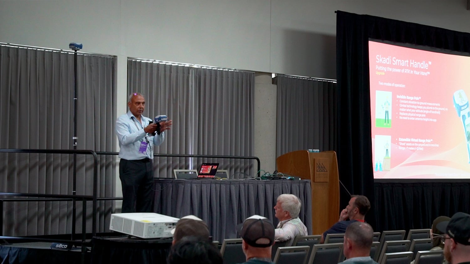
The Skadi Smart Handle™
The second set of main features that we have are within the Skadi Smart Handle. When you insert your Skadi Smart Handle, you can activate it for two modes.

The Skadi Invisible Range Pole™
One of them is called the Invisible Range Pole™. A lot of people have some idea of the “RTK In Your Hand™,” We have brackets for the Arrow Series and technically you have been able to have RTK in your hand, fine.
But with regard to the antenna, there’s no way to put an antenna height into Field Maps when you’re continually moving while using a handheld. To do that, you’d need your elevation to be always computed at your hand level. So that, as you move, your antenna height calculation goes up and go down. Traditionally if you did this, you never knew what the elevation to the ground was.
And this is where the we have integrated the LiDAR sensor along with the inertial sensor of the Skadi Smart Handle. Using the Invisible Range Pole, you’re now able to get your continuous elevation to the ground.

So think of it. Even if I’m like this [gestures], think of it as a plumb going down to the ground and always measuring your perpendicular to the ground. This is one feature. So you can be standing on top of a of a manhole, hold it there, record your point in Field Maps, and then what you get is X, Y, and Z values.
The Skadi Extensible Virtual Range Pole™
With the second mode, we thought, while we’re here why don’t we do a little bit more? So with the press of a trigger, you can change modes. With the press of a trigger you can now use a laser pointer that turns on to aim at assets nearby. It’s not a laser offset, mind you. Think of it as taking this pole and extending your pole to about 20 ft and capturing an asset on the ground at that distance.
It uses the same principle as a tilt, but we call this feature the Extensible Virtual Range Pole™. How is that beneficial to you? You have valves and manholes in the middle of the street. You don’t want to go there, so you can just become lazy instead, and just aim and shoot your asset from afar and right away populates in Field Maps. You want to map the center line of a road? Stay to the side, aim, and zoom.

Another thing that it’s going to be extremely useful for is for as-builts, for assets that are ready to be buried, like in open trenches. People hate going in there, I heard. With this feature, you can just stand on the top, and you don’t have to go there anymore. So, you have a valid RTK position in your hand, your laser pointer points, and you can map your entire line sections or individual points along that structure and map them with vertices. Or you can hold the trigger and map them continuously as a line feature — point every second. So, that is a short distance, but it does what it does. It does a lot. So, this is the second feature of the Skadi Smart Handle: the Extensible Virtual Range Pole.
Who is Skadi?
Skadi is agile. She’s on a mission. She has that same precision with her arrow, but she also goes downhill on slopes with her skis while hunting and being precise. She’s on a mission. She’s got a goal. And this is what the product is all about. The product embodies what Skadi is — getting an accurate measurement, doing your job while being on the move, and not having to waste time.
Now, who is Skadi? Let’s go back to that. In the Norse mythology, she is known for hunting on skis. You see, on the bottom left, you have Heracles, which we use on the Arrow products. It shows Heracles foot on a rock with a bow; he aims with an arc and gets you the accuracy that you want.
Skadi is agile. She’s on a mission. She has that same precision with her arrow, but she also goes downhill on slopes with her skis while hunting and being precise. She’s on a mission. She’s got a goal. And this is what the product is all about. The product embodies what Skadi is — getting an accurate measurement, doing your job while being on the move, and not having to waste time.
There’s no need to level your bubble again collect your point. You just go on, take the laser, switch to a handheld — and shapeshift. The handheld, I call this her Arrow quiver. And using your whole quiver, you can take an arrow and shoot.
So this is who Skadi is, and this is what embodies, really, this product.
We developed this product in a way that Field Maps can consume everything that we’re doing without even supporting any special features of Skadi. Field Maps will just consume everything that we send; we control everything. There is ongoing work, and we’ll talk about this about this a little bit later, for integrated metadata for Skadi Tilt Compensation inside Field Maps; some other features that Field Maps could use from the Skadi Smart Handle; and other the data that could be used. We’re working together with Esri, and we’ll talk more about this, but in the fall, we should start seeing things hopefully.
Eos Positioning Systems Road Map
And quickly, I’ll conclude with a roadmap on the Skadi Series ongoing development.

The product should start shipping in late August, or early to mid-September. They’re probably going to be doing some slow shipping at the beginning. But there’s some development going on also, mostly on the app side. Subscribe to our newsletters too, to learn more on when we start shipping.
Regarding the Arrow Series, the Arrow Series is not going away. The Arrow Series and Skadi Series are basically built on the same technology. One of them has more features than the other, but the Arrow Series still continues.
We’re going to have some more development on our product line, especially for the firmware updates that people have been waiting for. We’re finally going to have the release of the new, next generation of Eos Tools Pro, which has completely been rewritten. That should be released in about a month, at the same time as we start shipping the Skadi products.
In 2025, we’re looking at possibly having the same type of handle, which is a very comfortable grip, for the Arrow receivers also. It’s not going to have all the features of the Skadi Series, but at least a physical handheld that will be there.
And for Eos Tools Pro, we’re going to have MDM (mobile device management) released for Android also. And all this should happen in Q3. We’re going to be adding also the 14-parameter data transformation to solve a lot of issues. So, we’ll be doing different versions for the California Spatial Reference System with the various epochs that they have. So all of this is going to be integrated into the next generation of the app. They are ready; it’s just that we’re waiting for the next generation of the app to be out.
And Windows, in the fall, we’re going to have a Windows version that supports the features of Skadi Series. But I don’t know if there’s any a lot of people using the Windows version of Eos Tools Pro.
So with this, I’ll pass it on to Eric.
Next Generation BYOD GNSS

ERIC GAKSTATTER [Discovery Management Group]: So hey, I’m Eric Gakstatter. I’ve been in the GNSS industry for 30 plus years now. And if you’ve been in this industry for a while, you’ve seen a lot of different transformations, right? You know, it used to be the old handheld GPS. I’ve got some pictures of me using handheld GPS back, you know, 20 years ago. I mapped a lot of golf courses, actually.
The History of High-Accuracy BYOD (Bring Your Own Device)
It’s come a long way. The major transformation really was the BYOD (Bring Your Own Device) transformation. So from proprietary data collectors, which I started out with, I was with a company called CMT back in the 90s, here we had our own (it was a spin off of a field backpack). We had our own data collector that would run an RS-232 serial cable to a GNSS receiver and collect data that way.

And there was a ton of different proprietary data collectors because that’s when mobile barely existed. iOS and Android didn’t exist at all. And so it was a huge transformation 12 years ago or so when iOS and Android really started to come on strong as mobile phones proliferated. And of course, we started to think about how can we use these as data collectors for GNSS data?
And then Jean-Yves came up with the idea of Bluetooth-ing. He came up with the first iOS Bluetooth submeter receiver and RTK receiver. I’m going to talk about that in just a little bit, that whole transformation, as this sort of represents, in my mind, what Eos is introducing is sort of the next phase of BYOD.
The benefits of BYOD in general are that in the past 10 years, we went on a transformation. First we had the mobile device with the GNSS receiver integrated, so you had a handheld with Windows Mobile® operating system and with the GNSS receiver all in one. That was a great machine for a long time. That did a great job.
But what happened to those was that Microsoft® would stop supporting that operating system, and then you were stuck. What do you do now? So, at that point, instead of one handheld package, you started to see them separated. You separate the data collector from the GNSS receiver, and that’s when the whole BYOD (bring your own device) concept came around.
And of course, there were benefits. You expand the life of the mobile device, so there’s not obsolescence with the operating system. That was a big deal. And what you see now is, even more recently, when we separated the GNSS receiver years ago and started using Android and iOS devices, GNSS.manufacturers and users tried to find certain ways to bring them back together. They would take Android devices and wrap plastic around them and sort of put an antenna on top of that. But that’s tough, because when you ship that kind of device and it’s all tightly integrated like that, then when you go to try to update the operating system, what happens? You can’t.
Android changed so much over time, and with iOS you couldn’t do it at all. And so, you’d have a device that you bought that would be obsolete after two or three years. We saw many cases of that, and maybe some of you suffered from that too.
Why Not Use Standalone Mobile Devices?
There’s always this debate when I talk to field people of, “Hey, why can’t you just make everything in one mobile device? Why can’t you put RTK in your phone? Why can’t it just be just a simple device? And why do I have to have these add-ons?”
So I actually talked to the Apple and the Android folks. I asked them, “Hey, why can’t you put RTK in the phone?” Their answer is interesting. The chipsets they use are more than capable of it, but they don’t want to allocate the resources to power the kind of antenna you would need to make that work reliably. So, it’s not going to be in the foreseeable future that you’ll have centimeter accuracy or even submeter accuracy on your phone.
In fact, it was interesting. Probably four or five years ago there was a chipset from Broadcom that was dual-frequency and people started talking about, “Hey, you’re going to get high accuracy on your phone now, because now Android and iOS are going to have these really high-end chipsets.”
But the reality is, it doesn’t happen because mobile phone manufacturers really don’t care about entering the high-accuracy market. So, they’re not going to spend the money. I remember talking to some Samsung® folks and they said, “Look, if we have to spend two more cents — two more pennies — on the antenna, we can’t afford it.” Because you multiply it over, you know, 50 million phones or something like that.
So, it’s interesting that there’s news releases out about new chipsets, GNSS chipsets, and so on for high accuracy. But the reality is that the iOS and Samsung folks are never going to implement that. So, you’re left with having a separate antenna and a separate GNSS receiver. And how do you then incorporate it into one handheld package?
So, the GNSS market did that. Ten, 12 years ago, Jean-Yves and his crew and others said, “Hey, we’re going to use Bluetooth. We’re going to have a separate receiver with your iOS or Android device.” And they it made it work for a long time. The Arrow Series has been on a great run for the last 10 to 12 years. But it’s time for the second generation, the second transformation of BYOD.
The New Phase of BYOD: Sensor Integration
It’s interesting because I’ve been talking about this for a long time at different conferences. And there has been this whole idea of sensor integration. I was excited when Jean-Yves showed me the Skadi Series, because now we’ve seen the sensor integration start to happen.
It’s not just a mobile device Bluetooth-ed to a GNSS receiver that’s getting a position. The Eos technical team has taken that a step further and integrated the tilt part of it.

Benefits of Skadi Tilt Compensation
If you’ve collected a lot of data, you can understand how much time it takes. I’ve been on many golf courses where I’m just mapping irrigation heads. And there’s, I don’t know if you knew it, but there’s probably upwards of 2,000 irrigation heads in a golf course. And so, you’re constantly planning. Each additional second is a second you don’t want to worry about. When I’d go out and typically map a sprinkler, I walk up to it and bubble up. I have to look at the bubble on the range pole, tap the button to store a point, make sure I’m bubbled up, and then move on.
Whereas now with this whole Skadi Tilt Compensation feature, it’s amazing. You should come by the Eos booth, and they’ll show it to you. You can just walk up and, as long as your range pole is on the asset that you want a map, it doesn’t matter if you’re level or not. Just hit the store button, and the receiver automatically outputs the data for that point on the ground instead of where the antenna is.
I spent years and years telling people, make sure the antenna is where you want to map, because that’s what’s going to be mapped, right? But that isn’t the case anymore. That tilt sensor integration is cool. And it’s not it’s not the first time that someone has done it. But I think Eos has done it in a way that it’s very affordable now. You don’t see it in any class of receivers that Eos is introducing.
Benefits of the Skadi Smart Handle Features
So the second, maybe even more cool feature in my opinion, that’s more innovative is the whole Skadi Smart Handle capability. And again, you can go down to the Eos booth and have them demonstrate it to you. But you’ve got a trigger on this handle. It’s got a laser pointer. It’s not a laser rangefinder. It’s just a laser green-dot pointer that you can see out to about 20 ft. And it’s got a LiDAR sensor that does the measurement to that point. So you’re actually getting the position of the asset that you’re pointing at.
Related to this feature, I talk to a lot of utility field crews about mapping inside trenches — and not having to jump down inside the trench. That’s always a big safety concern, especially when you get unions involved and other things like that. So, yeah, I think this is going to be a big innovation. And it really brings together that whole sensor fusion concept that’s been discussed for many, many years. I’ve been talking about this for 10 years. And so, we’re finally seeing the IMU coming together with the LiDAR sensor and the laser pointer.

Any questions at all along those lines or anything about trends at all? I mean, still, you know, in terms of GNSS, we’re still at four constellations. Jean-Yves talked about how the Galileo HAS correction service is going to be improving. We’ve seen a lot of uses of it, and it’s brought some really amazing positioning to areas where you don’t have any connectivity at all. Of course, I’m still a big RTK person. We deploy a lot of RTK systems. But what’s the Achilles heel of RTK? It’s connectivity. So the Galileo HAS correction service allows you to work in crazy parts of the world with no connectivity. Or you can use Starlink. And we’ve started to use Starlink now for connectivity to out in these, remote locations.
Upgrading Your Mobile Data Collection with Skadi Series Features

So, I think the last thing I want to discuss on this that I think is cool is the whole idea of, you don’t have to buy everything at one time. You can just buy a straight-up receiver, either on the pole or using the standard handle, and use that out of the gate. If you want to add tilt later on, you email Eos and say, hey, I want to buy tilt. They activate it over the air so you don’t even have to worry about sending a receiver back. So, tilt is easily activated, and the Skadi Smart Handle is just a simple accessory. You saw how Jean-Yves just pulled it out, and you just add in the smart handle to access the LiDAR and MEMS capabilities.
In my mind, and this isn’t the marketing spiel that Eos gives you, but I think the beauty of it is that you can phase in these different technologies over time. You can buy a receiver this year, activate tilt next year, buy a smart handle later on and activate those features in it. From a budget standpointand a flexibility standpoint, I think this adds a lot of value.

ArcGIS Field Maps Update

JEFF SHANER [Esri]: Thanks, Eric. So, as Sarah introduced me earlier, I’m Jeff Shaner, I’m the Lead Product Engineering Director for our ArcGIS field apps. And what I wanted to do today was kind of talk to you about ArcGIS Field Maps, where we are today, and overall what our strategy is with field operations at Esri.
How many people here are using ArcGIS Field Maps in their day-to-day work? The vast majority of you, great.
ArcGIS Field Maps Strategy

You know, just to kind of recenter on what our strategy is overall, what we’re doing with our mobile products is looking at all industries that we support with ArcGIS and trying to bring the concepts of maps and forms out to the field for different types of use — whether that be the way that you plan and coordinate between the field and the office to improve overall situational awareness, or whether it be using maps or forms as a container for capturing and updating information that goes back into the GIS. And I’m sure a lot of you here today are using it for that purpose.
I’d say of all the vendors that we work with and support today, we’re seeing the most growth and rapid adoption of the Eos-based receivers.
Our integration with Eos Positioning Systems is critical to that success, as I’m sure a lot of you map asset locations that demand high-accuracy GNSS integration. It’s been wonderful to work with Jean-Yves and the Eos team. I’d say of all the vendors that we work with and support today, we’re seeing the most growth and rapid adoption of the Eos-based receivers. It’s wonderful to see that happening, and the Skadi being introduced and that technology evolving once again. So, thank you, Jean-Yves.
So, we look at all of these different patterns of use and we try to build applications and capabilities that best suit the common needs between each. As you know, data collection is so important that we have three applications to support it. And they all are usable with Eos receivers. We continue to grow each of those applications with new functionality all the time.

With ArcGIS Field Maps, what we’ve done is we’ve kind of exemplified those patterns of use, that planning and coordination, that using maps for situational awareness — using maps as a container for data capture. And if you weren’t aware of Field Maps as a mobile application, it supports all user types in the system. And you know that those user types just changed, right?

So, if you’re using a viewer or using a Contributor License, you can take maps out into the field and view them. You can view them with high-accuracy GNSS receivers. They can work offline. You can get geofences that notify you of information that’s nearby. So, there’s a lot you can do without even editing inside of Field Maps. And what we’ve done as part of ArcGIS Field Maps is merge three applications together. Historically, we merged ArcGIS Collector, if you used that in the past, ArcGIS Explorer, and ArcGIS Tracker into one app.
ArcGIS Field Maps Designer

In order to continue to grow the functionality of ArcGIS Field Maps and still keep it simple and easy to use for those whom you serve out in the field, we introduced a web application called Field Maps Designer. You can see it here [gestures to the screen]. How many people here have used Field Maps Designer? For those of you that put up your hand and said you use the Field Maps mobile app but didn’t put your hand up for Field Maps Designer, you should feel shame right now.
[audience laughter]
You should feel a lot of shame. Because you’re not doing the best for your mobile workforce, right? You can configure that experience so that they make the most out of it, and you get the most out of it, too. We continue to grow Field Maps Designer to introduce new functionality into the mobile application as well.
You’ll see that in the list of things I have in the “What’s New” slide coming up, which covers the past three to four releases.
What’s New in the ArcGIS Field Maps Mobile Application

Of course, you’re all familiar with the mobile application, for those of you that have used it. And starting with the first release of Field Maps, you can tell we’ve done a lot more with it, right? We’ve not only continued the integration of GNSS receivers and supplemented some of the data capture functionality for spatial, but also introduced forms. And the way that we did that with forms is that we worked with the other teams at Esri to build a new form specification, that form spec.
And the components for designing a form that are in this Field Maps Designer app I just talked about are inside the map viewer and inside of ArcGIS Online and Enterprise. Those forms are now executed in that new web editor that just got released in ArcGIS Experience Builder, and we’re taking that to ArcGIS Pro as well. So, you don’t have to do that dumb attribute editing anymore in future versions. So, the next goal for us of those forms is inside of ArcGIS Pro.
But we continue to grow and add new functionality around those patterns of using a map to notify people, using a map to capture data, using a map to inform you from the data that’s within it. This includes things like support for utility networks and support for linear referencing. We’re going to bring more support in for rasters here in the next little bit. So, there’s a lot of functionality that continues to grow inside of the mobile application as well.
ArcGIS Field Maps Integration with Eos GNSS Receivers

But what’s really important for data capture is this integration with the GNSS receivers. And like I mentioned, the Eos units, the new Skadi Series, this revolution in technology that Eric was talking about over the years, is really important to the work you do. So, we want to make that as seamless and easy as possible. So, what we do today is we’re leveraging the Bluetooth connection — if you know this from using, perhaps an Arrow receiver — we pull all of the information off that Bluetooth stream, and we can leverage it inside of the data capture today.
But what Eos has done is taken that even further. Within the Eos Tools Pro application, you can extend the data capture capabilities of Field Maps. Because we support very basic things like, you know, maybe GPS averaging or a simple vertex capture. But with the offsetting capabilities that they’ve introduced and with the line locating capabilities, you can do such so much more.
Is anyone using the Eos Locate capability or the offsetting capability that’s here today? Okay. Well, if you’re not, you should go check that out.
And, you know, we’re continuing to work really closely with Jean-Yves on how we’re going to take advantage of the new features that the Skadi Series is providing. Especially with the trigger capabilities moving forward, and the tilt capabilities and all that.
What’s New In ArcGIS Field Maps: A Roadmap
ArcGIS Field Maps was born in November of 2020. It was a COVID baby.

All right. As far as what’s new, ArcGIS Field Maps was born in November of 2020. It was a COVID baby. And we’ve had a lot of releases since. We release three times a year. And we do that because we’re hitched to the ArcGIS Online updates. The source code for the Field Maps Designer is inside of ArcGIS Online’s code base. And then that code base gets refactored into future versions of ArcGIS Enterprise, and it kind of goes along like that. So, we always release major updates three times a year.
And you can see a lot of change. I’m not going to go through this full list, obviously. But I’ll point out in June of last year, right before this conference last year, we added some new functionality to really help promote the accurate capture of spatial data. That includes bringing into those requirements for accuracy, the fix type, and also the ability for you to remove a user from being able to capture with a map. So, if you want to force someone to use GPS, you can do that inside of Field Maps.
And we’ve been spending a lot of time adding more functionality to improve things like offline workflows, inside of the product. And you can see a lot of that, rippling through each of those release versions.

We do have another update, coming in October, November-ish. We’re really laying out the date now, again, more focused on Field Maps Designer, with some very modest capabilities. One of the things we did quite recently inside Field Maps Designer is to let you create new maps from scratch. So you don’t have to go use ArcGIS Pro, necessarily, to create a map anymore. You can create a map in that designer app. Design the form if you’d like. Creature your feature layers. And in fact, we even added the ability for you to create a new feature layer in a local projection too — something you can’t do outside of ArcGIS Pro anywhere else.
We’re going to start to introduce templates this fall. Things like simple map notes or perhaps a template map for creating points for drone flights, control points for drone flights, stuff like that. So, we’re working with the solutions team to deeply integrate some of the solutions as well. So, see this kind of quick ability to create maps and lower the bar of entry for using Field Maps within your organization. So you don’t have to necessarily be a GIS professional to get the maps out to the field anymore.

Not much on the mobile front right now, because right now we’re actually in a rebuild of Field Maps. We’ve been in that process for almost a year now, and in Q1 of next year, we’re going to release a brand-new version of it. In fact, we’ve got early updates of it happening now, and there’s a bunch of new features that are coming. Has anyone used ArcGIS Workforce before to organize their work?
We’re introducing the concepts of ArcGIS Workforce into Field Maps, and we’re calling them field tasks. So you’ll be able to organize the work that someone does in the field. Like, I wouldn’t want to send Matt Davis out to go capture a bunch of data on his own. I’d want to give him a list to do, so that I know I can go back and look at what did he actually do and track his work.
That’s a major new development for us. And probably a year or so following that release will deprecate Workforce. So you can know that we’re not going to continue to develop Workforce. New functionality is going into the task coordination capabilities.
We’ve been supporting utility networks for some time. Important is being able to take them offline and view and trace. We’re overhauling our personal markup experience, really working with the stylus. We’ll eventually bring that into data capture of the map too to be able to freehand sketch in the map. And we’re working on being able to support the edit multiple tool with forms, finally, a big request from a lot of customers.
On the location side, one of the things that we’ve struggled with is we’ve had multiple location providers inside of the application. And that means that if you’re using geofencing or location sharing, it couldn’t take advantage of the Skadi Series receiver, for example. It was using the integrated location coming from your iOS or Android device. Now that is fused together.

So we’ve got a lot of new developments coming there. And look for that to be released in Q1 of next year. Obviously, the Utility Network is coming. And if you want to talk to us at the Esri booth, you can come down, into the expo. And also Jean-Yves, we’ve got the Eos Positioning Systems booth that’s really close by to the Esri booth. We want you all to come down and interact with the Skadi Series.
Conclusion

And then I think that’s it. If there are any questions, or if you want to contact Eos, putting that slide back up, you can see the QR codes here.
JEAN-YVES: Thank you, everyone
[audience applause]
Explore Related Content

Eos Positioning Systems Announces New Line of GNSS Receivers: The Skadi Series™
Eos Positioning Systems Announces New Line of GNSS Receivers: The Skadi Series™. Discover the power of putting RTK In Your Hand™!
![What’s New in High-Accuracy GPS/GNSS for GIS Users [A 2023 Esri UC Session]](https://eos-gnss.com/wp-content/uploads/2023/07/Whats-New-in-High-Accuracy-GPS_GNSS-for-GIS-Users-A-2023-Esri-UC-Session-1024x576.jpg "What’s New in High-Accuracy GNSS/GPS for Esri Users [A 2024 Esri UC Session] 2")
What’s New in High-Accuracy GPS/GNSS for GIS Users [A 2023 Esri UC Session]
Learn about the latest developments in GNSS for GIS users, including support for Windows 11, MDM, Galileo HAS, and much more in this recorded presentation from Eos and Esri.