By Erin McGrath, Spicer Group
Editor’s note: This article was originally published by Spicer Group in Winter 2024 and is republished here with permission. View the original article here.
The City of St. Louis, Michigan, is located in Gratiot County and is home to more than 7,000 people. It spans 3.53 total square miles and was founded in 1853.
In 2008, Spicer Group began providing professional geographic information services to the City of St. Louis. A geographic information system (GIS) involves a digital map with underlying data attached to it, and is capable of analyzing the data and displaying specific features determined by its controller on maps. These typically include utilities, structures, elevations, land cover, city parcels, and similar features.
A Past of Using Paper
Prior to implementing GIS, the City relied on digital scans and paper copies of their utilities’ infrastructure like sanitary sewer, storm sewers, and drinking water pipes. These paper plans and digital scans however did not always reflect an “as-constructed” condition, meaning the real knowledge of the system—the condition and location of the utilities—sometimes resided only with members of the City staff. Each department in the City had its own set of plan files, which caused inconsistency.
St. Louis City Manager Kurt Giles said the City decided to implement GIS to maximize reliability and consistency within the City and its owned infrastructure. The City began the GIS implementation by hiring Spicer Group to assist with mapping the City’s plats, blocks, parcels, and municipal boundary lines.


Moving Forward with Digital Maps
In 2013, Spicer Group assisted the City of St. Louis’ Department of Public Works (DPW) with applying for a Stormwater, Asset Management and Wastewater (SAW) grant program. This grant program, provided by the Michigan Department of Environment, Great Lakes, and Energy (EGLE), was designed to develop an asset management program for stormwater and wastewater collection systems. The program allowed communities to plan for future improvement projects and recognize problem areas before they become emergencies. The grant gave St. Louis the opportunity to hire Spicer Group to survey and inspect manholes, televise storm and sanitary sewer lines, and build a ground-truthed GIS network of the City’s storm and sanitary sewer infrastructure.

The SAW grant culminated in publishing the City’s GIS data to the cloud, and selecting an asset management platform, enabling City field staff to access the information anywhere. This helped St. Louis get true measurements and stay up-to-date tracking costs on the underground facilities, allowing for more transparency with the public, the City Council of St. Louis, and the state government.
Success Inspires a Survey

The SAW grant program was so successful, the City of St. Louis decided to have Spicer Group survey all the water valves around the City and map the watermains to add more detail on their drinking water system into their network using the Drinking Water Asset Management (DWAM) grant program.
The DWAM grant program is a drinking water infrastructure financial assistance program developed by EGLE. This program assists communities with drinking water infrastructure with asset management, plan development, distribution materials and inventories as defined by the Michigan Lead and Copper Rule.
In 2020, St. Louis was awarded more than $370,000 in DWAM grant funding to verify the water service materials using the GIS system to flag areas that required verification to comply with state regulations.
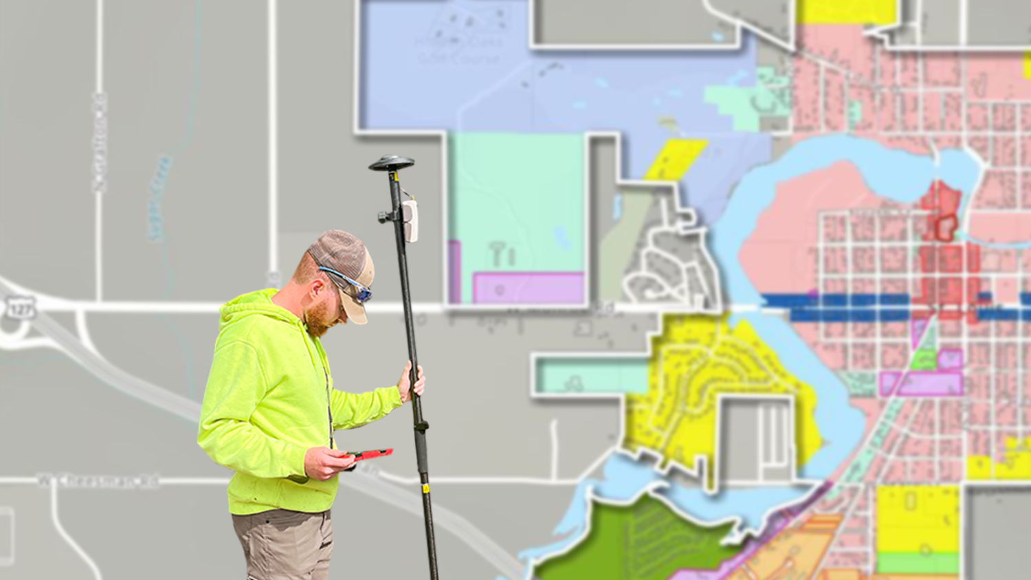
Spicer Group had been using the Arrow Gold® GNSS receiver from Eos Positioning Systems alongside the ArcGIS® Field Maps app from Esri on iOS® devices for several years. They were confident in the hardware and software combination being a great mobile mapping fit for the City’s water-survey needs.
“Other similar communities were using these receivers as well, so there were lots of good examples of Eos devices being a good fit for similar clients,” Spicer Group Project Manager Max Clever said.

The City invested in their own Arrow GNSS receiver, and Spice Group supplemented the surveying with one of their units. When connected to the Michigan Department of Transportation (MDOT) CORS network, the field staff achieved an average accuracy of 1 cm.
Spicer Group is continuing to provide the City of St. Louis with the necessary resources to verify their water systems and make future improvements.
Benefits and Looking Ahead
St. Louis is now benefiting from a well-organized, accurate, and up-to-date database of their key infrastructure assets. Every time a new piece of infrastructure is constructed in the City, Spicer Group assists in updating their GIS to keep all maps current and assists departments in continuing to improve the City’s infrastructure assets.
“Spicer Group has been able to obtain plan files from different departments to scan and index the information and then make the information available on GIS. Working with Spicer Group has allowed us to add current, as-constructed, drawings to our system as projects are completed,” Keith Risdon, the City’s Public Services Director said.
Keeping GIS information up-to-date is extremely important for not just the City of St. Louis, but all entities that use GIS. Spicer Group continues to keep the City up-to-date on their asset management software and GIS.
Ultimately, municipalities can avoid costly catastrophes by utilizing GIS to ensure the integrity of their sanitary systems, water mains, and drinking water systems to reduce the risk of damage or emergencies.
You May Also Like One of These Success Stories

A Forward-Thinking Michigan Municipality Implements High-Accuracy Maps for Program Management
The City of Saline brought GIS in house, deployed high-accuracy GNSS receivers, and is working toward a streamlined longterm master plan.

Oakland Co., MI, Maps Underground Utilities with Eos Locate
In this recorded Eos Locate case study, Michael Cousins explains how underground mapping (Arrow Gold®, Collector) improved legacy buried-asset records.
