PESH is on a mission to explore and map México’s Sistema Huautla, the Western Hemisphere’s deepest cave. The Arrow 100 GNSS receiver is helping them prove their survey findings.
By Thomas Shifflett, Co-Founder, PESH
")
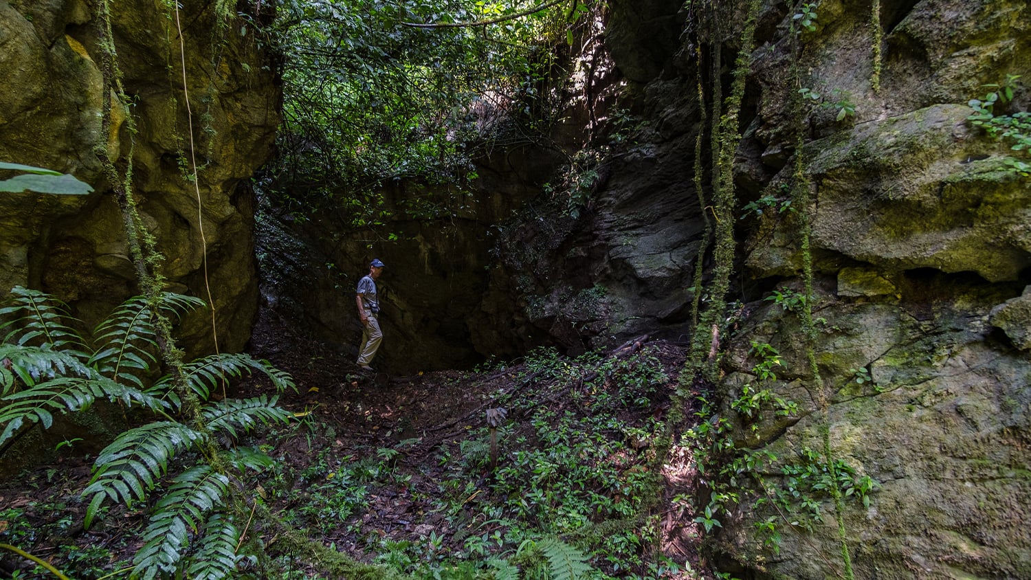
Several hours have gone by since leaving our underground camp in Cueva de Elysium, an underground cave, to reach the farthest point of our exploration on this trip. We momentarily stop for a water break. Sweating profusely in our effort to reach this cave location, we will soon begin surveying and mapping an unexplored passage — a place never before seen by any human. The break does not last long before we need to begin moving again to warm up. A steady breeze moving through the cave has caused our sweat to evaporate and our bodies to chill. Exhausted from climbing, wading, crawling through water and mud, and squeezing through crevices, we think not about the long and arduous journey back to camp, but rather the thrill and curiosity of where this passage will take us — and what we will find.
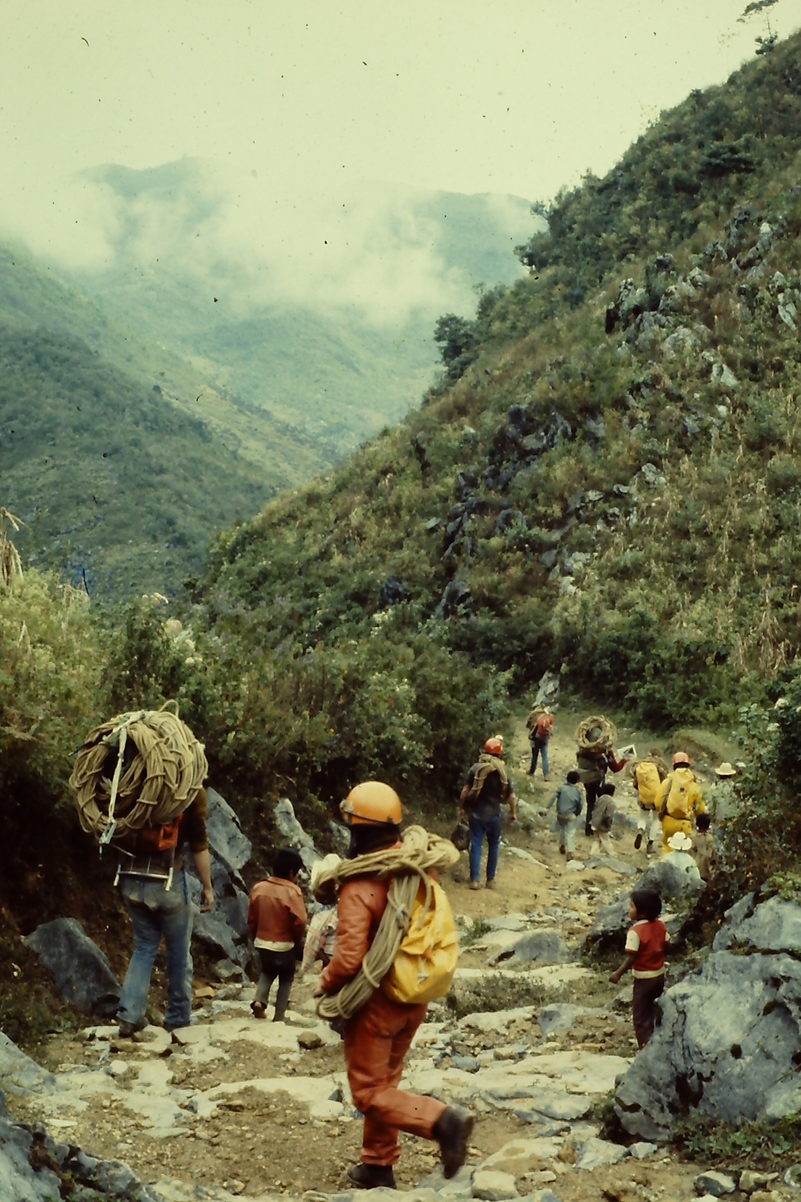
This is how our cave exploration goes. By “we,” I mean the Proyecto Espeleológico Sistema Huautla (PESH), a group of passionate cave explorers, mappers, and supporters who explore the Sistema Huautla yearly, most recently in April 2024. The Sistema Huautla is found in México’s Sierra Mazateca mountains, in the state of Oaxaca. My description barely captures what it’s like to explore this system, one of the world’s deepest cave systems now mapped to over 100 kilometers (~62 miles) in length. There are steep rock piles, many over 30 meters (~98 feet) high, to climb; crevices and rock piles that can send loose rocks at any moment and make you feel squeamish; heavy packs of rigging hardware, rations including water, surveying equipment, and more weighing 15 to 25 kilograms (33-55 lbs). All of this you carry across traverses with dangerous drop-offs and steep, unstable, sometimes slippery slopes.

Exploring unexplored deep caves is neither easy nor comfortable. It’s different than a tourist trip to a commercial cave. Just getting to a cave entrance can require survey planning to locate an entrance, some of which are hidden in dense jungle on steep terrain. The travel to unexplored passages can sometimes take 12-30 hours, descending dozens of pits on rope, traversing kilometers of rocky passage, wading in streams, and at times crawling. But the reward of cave exploration is worth the discomfort for me. I am seeing places no human has seen before. Caves are one of Earth’s last frontiers. And in this article, I’ll share with you how PESH is studying and mapping one of the deepest, darkest frontiers that remains for mankind: the Sistema Huautla.

Sistema Huautla: A Puzzle of Place and Politics

Exploring caves is like solving a puzzle. Today, the Sistema Huautla has 30 entrances and over 101 km (~63 mi) of mapped passages. The Elysium entrance was discovered in 2019. One day, we hope to connect it to the Sistema Huautla. This is our puzzle: The number of potentially undiscovered caves and passages that could be connected to Sistema Huautla is immense. Sistema Huautla could potentially reach 200 km (~124 mi) in length or more, including a vertical depth that could exceed 1,800 meters (~5,900 feet). The distance between Elysium and Sistema Huautla’s spring resurgence is nearly 18 km (11 mi), and much of the cave between the two has yet to be discovered.
But there are many hurdles in exploring the cave beyond its physicality itself. The indigenous Mazatec people who live there believe there are cave spirits that should not be disturbed unless given permission through a shaman’s ceremony. The Mazatec people also suspect we (the researchers) are there to remove gold and other valuables. We are sometimes able to mitigate these issues by attending shaman ceremonies that demonstrate respect for the cave spirits and by showing photographs of what is down in the caves. We also contributed to the local economy by renting buildings used during expedition staging, by providing funds to improve their roads, and through other endeavors. Through our public relations effort we have conveyed to the Mazatecs that the real value for us is the discovery, science, and adventure. The only thing we take from the caves are photographs and data.
We also need jurisdictional permission from both the governing Presidente seated at the mountain city of Huautla de Jiménez, from the local village leaders (agente), and from any landowner an entrance is on.

A Brief History of Sistema Huautla: Discovery and Exploration

The first cavers to reach the Huautla karst (an area of limestone rock with sinkholes and caves) were University of Texas students in 1965. A 60-km (37-mi) unpaved road connecting the cities of Tehuacán and Oaxaca to Ciudad Huautla de Jiménez had just been built. It took a full day to drive the unpaved road to Huautla de Jiménez. A geology professor had helped identify the karst by using the university’s geology maps and aerial photographs. He found clues that a deep cave system might exist thanks to his identification of thick limestone beds, no surface streams on the map (despite 100 inches of annual rainfall), and a deep canyon to the karst’s south where springs might emerge. Upon reaching the city, which then had a much smaller population than today, the students found most locals were indigenous Mazatecs. Few of them spoke Spanish, but eventually someone told the students where to find two large cave entrances. The entrances were located several kilometers east of Huautla de Jiménez, then several more kilometers south of the village of San Andrés Hildago, at the village of San Agustín Zaragoza. They were told one entrance had a large stream flowing into it.
It wasn’t until the next year, 1966, that cavers from Austin, Texas, visited the entrance without the stream, now named Sótano de San Agustín.
In 1967, Canadian cavers descended the entrance with the stream, now called Sótano del Rio Iglesia. They explored the cave to a depth that then became the Western Hemisphere’s deepest cave. The next year, a joint U.S. and Canadian team explored Sótano de San Agustín to an even further depth, setting a new Western Hemisphere record. They worked from an underground camp at an incredible 300 vertical meters (984 feet) below the entrance. At that time, this was considered very deep!
Unfortunately, the Mexican Army soon closed the road to foreigners (because hippies had begun congregating at Huautla de Jiménez to consume hallucinogenic mushrooms that grow naturally in the area). It would not be until 1976 that cavers returned.

From then on, expeditions occurred annually. In 1980, a cave found the year prior that connected to Sótano de San Agustín was explored to over 1,000 meters (~3281 feet) deep. This required diving through three separated sumps (water-filled passages) to set another Western Hemisphere record, as well as finding the world’s then-third-deepest cave. Upon connecting these two caves, the interconnected system would now become Sistema Huautla.
Expeditions continued through the 1980s. In 1981, a team found what remains the highest entrance to date, Nita Nanta; this entrance was eventually connected to Sistema Huautla during another cave dive. This set another Western Hemisphere depth record, which tied the second-deepest cave in the world. As additional expeditions occurred in 1988 and 1989, a movie was made called Huautla: The Mexican Cave. (You might be able to find it online today, including here on Vimeo at the time of this article’s publishing.)
In 1994, a major expedition dove into a deep sump at the lowest point of Sótano de San Agustín. Unfortunately, a British diver drowned. After recovering the body, the team continued its expedition. They found a large passage beyond the sump which led to a much larger and deeper sump, called Sump 9 — also known as the “Mother of All Sumps.” This became the deepest-known point in Sistema Huautla at that time. A book titled Beyond the Deep was written about this expedition.
No other expeditions were organized until 2001, by a team determined to find the stream that flows into the deep entrance pit of Sótano del Rio Iglesia. This missing stream was not found. The next expedition in 2007 also focused on Sótano del Rio Iglesia. This team connected the Sótano del Rio Iglesia entrance to Sótano de San Agustín, thus confirming 20 known entrances into Sistema Huautla.


The Creation of PESH

British cavers led the next expedition in 2013 with an objective to dive the Mother of All Sumps. I had the fortune of joining this expedition. A dive team dove to 81 meters in an underwater pit going as far as they could, limited only by the gas mix they had. This dive reestablished Sistema Huautla as the Western Hemisphere’s deepest cave, having briefly been surpassed by Cueva Cheve, also in the Mexican state of Oaxaca.
During this expedition, fellow caver Bill Steele and I mused about the yet unexplored karst areas that might connect to Sistema Huautla. We suspected an even larger and deeper system could exist. So in 2014, we organized the Proyecto Espeleológico Sistema Huautla (PESH) with the goals of supporting cave science (especially Mexican cave scientists) and of mapping Sistema Huautla to 100 km (62mi) in length and 1.6 km (1 mi) in depth.

The Sistema Huautla provides a wonderful research area for geologists, paleontologists, karst hydrologists, paleoclimatologists, and cave biologists. Within the Sistema Huautla, biologists are studying a new species of tarantula and an adapted, aquatic white scorpion species that lives in the system’s streams and pools. In fact, many papers about the Huautla karst’s 40 unique species of cave-adapted lifeforms have been published in various journals. There is an exciting, ongoing study of Pleistocene-era mammalian skeletal remains that were found in some of the caves.
In creating PESH, it was also important to us to test new gear for exploration and mapping caves.


![According to Shifflett, "This is a photo of Berta, a Mazatec lady who was a little girl back in the late 1970s and early 1980s who lived in the San Agustín community. She would later marry a Mazatec man and move to Plan de Escoba, the area we [PESH] are exploring to the north of Sistema Huautla. In early 2019, prior to the 2019 expedition, Berta identified Bill Steele as someone from her past, and she offered to rent PESH some of the buildings owned by her and her husband to use as a base camp. Otherwise, we had no access to this area. In the picture, Berta is preparing tortillas in the same way as done for centuries — hand made and best I have eaten." (Photo by Matt Tomlinson)](https://eos-gnss.com/wp-content/uploads/2024/10/2023-0414-Matt-tomlinson-photog-DSCF2112co-Berta-Mazatec-tortillas.jpg "2023 0414 Matt tomlinson photog DSCF2112co Berta Mazatec tortillas")

A Brief History of Cave-Mapping Technologies in Mexico

To map early caves, scientists used various compasses and survey tape. They filled notebooks of grid-divided paper with sketches of passages in both profile and plan view. (Plan views is a schematic drawing that shows what a cave looks like from above, similar to a traditional map.) Scales estimated the relative size of each grid, and magnetic north was marked. Some symbols from sketches have been officially adopted by the National Speleological Society (NSS) and Association for Mexican Cave Studies (AMCS) to identify features such as mud, sand, water, pits, drop-offs, and cave formations such as stalagmites and stalactites. Cave passages were drawn based off field measurements, survey legs, and directional estimates.
Sketches were then transposed onto paper or mylar-film survey plots. Locations were estimated by using the latitude and longitude lines that were marked on geographical quadrangle, or “quad,” maps (maps divided into quadrants by these lines). However, early cave explorers did not have access to quad maps, so they relied instead on military aerial and satellite surveillance maps. Eventually, Mexican quad maps became available, though locations were still estimated.
Surveying Sistema Huautla in the 1970s

As exploration continued and more caves were located and “mapped,” the need grew to determine the cave locations more accurately, relative to each other and eventually Sistema Huautla. During 1977, an overland survey was launched to determine the locations of the known caves at the time. The survey relied on a compass; clinometer (an instrument to measure the survey slope angles); survey tape; and notebooks.
Because no survey monuments were available at the time, the overland surveyors used the corner of a structure in San Agustín Zaragoza as a reference point. They faced many challenges beyond the rugged terrain. In the absence of roads, they followed ancient trails used for centuries by local Mazatecs to travel between villages, water sources, and farmland. They encountered heavy vegetation, steeply sided sinkholes near cave entrances, and utility infrastructure both exposed and buried along the few roads, and sometimes trails that existed, that affected compass readings.
Concurrently in the mid-1970s, David McKenzie (now deceased) developed a software to calculate and compile survey legs for cave plan and profile views called “Ellipse.” McKenzie originally developed Ellipse for survey projects in Texas, Montana, and Mexico. Later renamed “Walls,” the software was offered free to anyone who could benefit from its use. Today, Walls remains free and includes features such as 3D survey-plot rotation; UTM coordinate calculations from GPS readings (which can then be incorporated into GIS shapefiles); and length, depth, and closure compilations.
At the time, backsights were not taken to mitigate magnetic influence and blunder readings. The survey instruments themselves introduced one to two degrees of inaccuracy. The overland survey’s resultant accuracy was less than ideal.
Since then, cave surveying and mapping technology has improved. In addition to Walls, cavers now have access to a battery-powered, distance-measuring device called the Disto-X, which provides more accurate distance, azimuth, and inclination readings. The Disto-X stores up to 1,000 measurements, which can then transfer readings via Bluetooth® to a mobile device or computer. Using a caver app called TopoDroid on a phone or tablet, cavers can create sketches based on the measurements, which are then exported to mapping software to create final, polished maps.
Many cavers are moving to digital maps from paper. At PESH, our cavers use PDFs to navigate to unexplored passages. Some (very few) are using LiDAR to map caves. LiDAR readers offer several advantages, providing that they can be dragged through tight crawls, extreme mud, and water and have a range of up to 100 meters (~328 feet). Their downside is that they can be extremely costly.


PESH Pushes to Connect Caves from the 1980s
During early PESH expeditions, we tried to locate some of the earlier mapped caves and connect them to Sistema Huautla. Doing so would increase the system’s total mapped length, one of our key objectives. However, this proved difficult.
Many caves mapped in the 1980s were located in areas once cleared by Mazatecs for agriculture. But decades later, dense forest vegetation had regrown. To relocate the entrances, we conducted an overland survey between two high order survey monuments located several kilometers apart on a quad map. We would use these to tie in the starting point of the 1977 overland survey, from which we could calculate entrance coordinates. Our proposed methods mimicked those of the 1977 survey, but this time we took backsights to cancel out magnetic anomalies and to reduce errors. Our survey would be tedious, requiring noting many readings on paper.
Our overland tie-in had a closure error of ~40 meters (~131 feet) — larger than we had hoped but understandable given the methodology’s limitations. In our overland survey just as had happened in the previous one, we encountered compass readings that could be read to within only a degree, steep terrain requiring many high-angle readings, and buried water pipes and electrical wires capable of influencing the compass. The Walls software has an algorithm to distribute error between the two monuments, thereby providing coordinates accurate enough that, we believed, would allow us to find the two entrances using an off-the-shelf GPS device. But that turned out not to be the case.
Accuracy with an Arrow 100

For the 2016 expedition, PESH acquired an Arrow 100 GNSS receiver from Eos Positioning Systems. Prior to that time, we could not relocate some of the caves mapped in the 1980s. During the expedition, I recorded new coordinates, of the caves we could find, and entered that data into Walls for the overland survey. These coordinates were now accurate to within a submeter thanks to the Arrow 100. The Arrow 100 provides coordinates in the International Terrain Reference Frame 2008 (ITRF08) datum, which is compatible with Mexico’s quad map for this area (based on the similar ITRF92), so no conversion was needed. In the case of one entrance located down a steep sinkhole in thick jungle canopy, we took a reading from afar and measured the distance to the entrance with a Disto-X. In open areas with a good view of GNSS satellites, we achieved some estimated accuracies of around 0.35 meters. These coordinates were then used to replace the ones from the overland survey.
After updating several nearby cave locations with the Arrow 100 coordinates, I recompiled the overland survey and calculated an azimuth and distance from a cave that I thought should be close. This led right to the lost entrance!
One particular lost cave entrance, the Nita Nanta entrance, we could not find. This entrance was the farthest north on the overland survey. After updating several nearby cave locations with the Arrow 100 coordinates, I recompiled the overland survey and calculated an azimuth and distance from a cave that I thought should be close. This led right to the lost entrance! As it turned out, the 1977 overland survey had an error of around 300 meters (~984 feet) for this cave. We were thrilled to rectify this with our updated location.
 copy")
 - IMG_2089 - same area as a Mazatec corn field copy")
Accuracy Leads to Increased Depth Measurement and Higher Confidence

With most of the entrances updated with accurate coordinates from the Arrow 100, the calculated depth of the cave has increased by 15 meters (~49 feet). Our confidence in the accuracy of that depth has also increased.
Moreover, we have successfully connected two caves to Sistema Huautla simply by knowing more clearly where to look for potential passage connections on the survey line plots. The improved accuracy has helped support the scientists’ work as well. Where paleolithic bones and cave-adapted species have been found, their locations are mapped — as related to the surface above — with greater accuracy. Additionally, we’ve improved our understanding of the cave’s geology, including strikes and dips, and hydrology by knowing more accurately where passages are located relative to the surface.
Our work is far from done, but overall, we are extremely excited to bring these technological advancements and their implications for cave study far beyond what’s been done in the past. The extra depth we’re discovering and measuring could put Sistema Huautla as the deepest cave in the world, with over 100 km (62 miles) of surveyed passages. While we cannot guarantee this, there is a good chance it is the case. Of course, we don’t know where all the unexplored passages are until we find them. One thing is for sure: Having confidence in our depth measurements and passage locations as we connect more caves to the system is critical.
Learn more about PESH here and contribute to its research here.

About the Author: Thomas Shifflett
Thomas (Tommy) Shifflett is a retired Civil Engineer and Land Surveyor, from the Federal Highway Administration, Eastern Federal Lands Highway Division (EFLHD). His last years of work was managing the design of Special Projects at EFLHD. Tommy earned a BSCE, and MSCE from the University of Virginia, and George Mason University, respectively.
Tommy’s introduction to caving began as a teenager, when he and some high school friends came upon a cave entrance during a backpacking trip. The adventure and curiosity in exploring the cave would take hold, and this activity would become his passion in life leading him to join organized caving groups, and membership in the National Speleological Society (NSS). Tommy’s introduction to deep caving in Mexico began at the age of 23, and three years later joined the 1979 expedition in exploring and mapping Sotano de San Agustín, a year before the cave was connected to Li Nita to become Sistema Huautla, and the first cave to surpass 1,000 meters deep in the Western Hemisphere. Tommy has also participated in expeditions to the Dominican Republic and China. Other activities Tommy enjoys has been scuba diving, rock climbing, kayaking, and hiking, but caving will always be his passion.
Tommy would like to thank PESH co-founder Bill Steele for his input to this article related to the past caving history of the Huautla area.
 Thomas Shifflett photo by Wife Shifflett")
You May Also Like One of These Success Stories
Locating Potential Bat Habitats in Abandoned Mines with GIS
Bat Conservation International locates bat-friendly habitats with a combination of Esri ArcGIS Apps (e.g., Survey123) and Arrow GNSS receivers.
Do Giant Tortoises Make Good Neighbors?
Charles Lehnen uses brand-new Galileo HAS corrections with the Arrow Gold+ in the Galápagos archipelago. His work will study Santa Fe Island’s rewilding.
