Eos Positioning Systems

Tel.: +1 (450) 824-3325 (CAN)
  • Technical Support
  • EnglishEnglish
    • Français Français
    • Español Español
  • Home
    • About
    • Contact
    • Technical Support
    • Subscribe
    • Testimonials
    • Users
  • Products
    • Arrow Series™
      • Arrow Gold
      • Arrow 200
      • Arrow 100
      • Arrow Lite
      • Comparison Chart
    • Accessories
      • Antennas
      • Mounting Equipment
      • Extra Battery & Power
      • Field Gear
      • Atlas® Service
    • Tools and Apps
      • Eos Tools Pro
      • Eos GNSS Tools
      • Eos Utility
      • Eos Server
      • Arrow USB Drivers
    • Solutions
      • Geoid Height
      • Eos Locate™ for ArcGIS
      • Laser Mapping
  • News
    • Latest News
    • Success Stories
    • Events
    • Newsletter
    • Press Releases
    • Blog
  • Learning Center
    • Arrow
      • How-To Articles and PDFs
      • Video Tutorials
      • Arrow Datasheets (PDFs)
      • Manuals (PDFs)
    • GNSS
      • GNSS Articles
      • iOS and Bluetooth®
  • Partners
    • Field Apps
      • Esri
      • AmigoCloud
      • CartoPac®
      • Corvallis Microtechnology (CMT)
      • DigiTerra
      • Futura
      • GeoMobile Innovations
      • GI Geoinformatik GmbH
      • mapitGIS
      • SPOT
      • SST Software
      • TAXUS IT
      • TerraGo
    • Hardware
      • iOS
      • Android
      • Windows
      • Laser Technology
      • Tablet EX Gear
CONTACT
  • Home
  • GNSS Articles
  • How to Tell if Your Smartphone or Tablet is Using a Bluetooth GNSS Receiver’s Location

How to Tell if Your Smartphone or Tablet is Using a Bluetooth GNSS Receiver’s Location

by Eos / Thursday, 08 September 2016 / Published in GNSS Articles, How-To Articles, Latest News, News
EOS-TOOLS-PRO-Android

How do I know if My iOS or Android Device Is Using My Bluetooth GNSS Receiver?

One question we often are asked is “how do I know if my iPad/Android is using my Bluetooth GNSS receiver or the internal iPad/Android GNSS receiver?”. With legacy Microsoft Windows devices, it’s easy to assign the Bluetooth receiver to a “COM” port on the mobile device so the user knows, without question, that their data collection software is using the Bluetooth receiver. With iOS and Android devices, it’s not so easy.

Location Services. Both iOS and Android (and future Windows devices) use a concept called Location Services. Location Services is a central service that apps use for determining your location. This can be any app from Apple/Google maps to Esri’s Collector software. The most confusing part of Location Services is that it can derive location from a number of different sources, not just your Bluetooth GNSS receiver, and you don’t have the ability to select the location source. Other sources of location information, besides GPS, include Wifi and cell tower triangulation, both of which are much less accurate than GPS.

Another limitation of Location Services is that it only recognizes general information from the Bluetooth GNSS receiver. Specifically, iOS Core Location services only recognizes $GPGGA and $GPRMC NMEA data, which offers limited information about how the Bluetooth receiver is performing. Therefore, most app developers only report limited information from the Bluetooth GNSS receivers. Of course, after spending several hundreds or thousands of dollars on a high-performance Bluetooth GNSS receiver, users want specific metadata from the Bluetooth GNSS receiver, with the big one being estimated precision. iOS Core Location doesn’t support reporting estimated precision. This is why when you use iOS mapping applications, virtually no GNSS metadata is available or recorded in the app unless the app developer makes a specific effort to incorporate GNSS metadata.

screen480x480 screen322x572 (2)

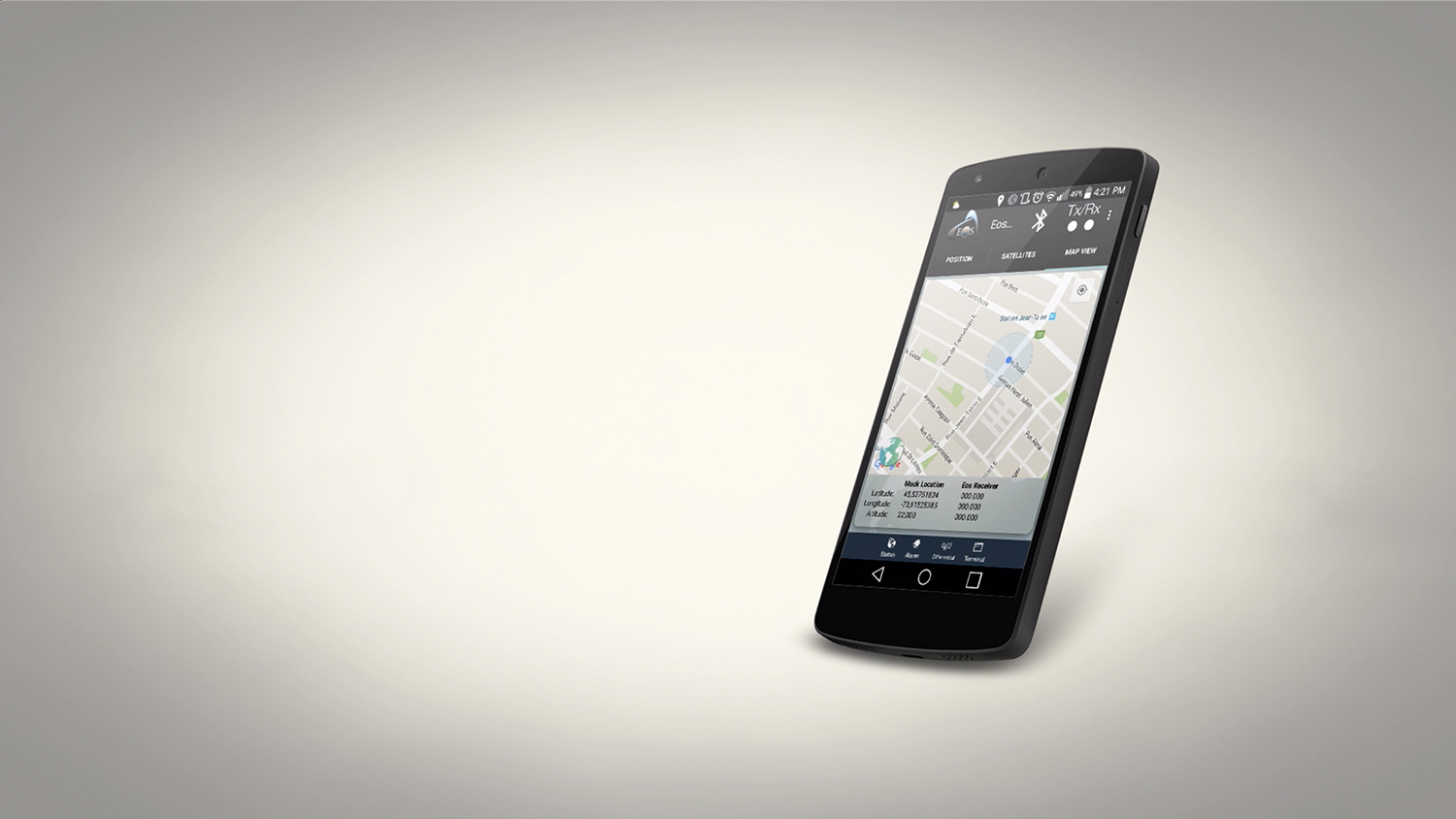
To overcome the deficiency of Location Services in providing GNSS metadata, the quality of the GNSS receiver companion app becomes very important. The companion app runs concurrently with the mapping app. For our products, we have companion apps for iOS, Android and Windows. Our iOS and Android companion apps display a lot of useful GNSS metadata, including estimated accuracy, age of differential correction, and detailed information about the satellites being used by the receiver. Equally important to GNSS metadata is the companion app’s ability to allow the user to set alarms and be warned if limits are exceeded. For example, if the user doesn’t want to record data if the accuracy is greater than 5cm, they can set a limit in the companion app to sound an alarm if the estimated precision is greater than 5cm.

screen480x480 (1) screen322x572

To answer the original question, “how do I know if my iPad/Android is using my Bluetooth GNSS receiver or the internal iPad/Android GNSS receiver?”, lies in the companion app. In our companion apps (Eos GNSS Tools for Windows and Eos Tools Pro for iOS, Android), an alarm will sound if your iPad/Android is not connected or using the location information from our Arrow receivers.

The value of our companion apps is that you can use them with any iOS or Android mapping app. Our companion apps give you the information and reassurance you need in order to know if you are collecting high quality data in your mapping app. If you’re a mapping app developer and would like to incorporate the functionality of our companion apps inside your software, please contact us and we’d love to help you do this. It’s a simple process.

This post is also available in: Español

Tagged under: Accuracy, Bluetooth, GNSS

About Eos

Our technical team pioneered the BYOD (Bring Your Own Device) high-precision Bluetooth GPS / GNSS market more than a decade ago when they designed the SXBlue product line. In early 2014, this same team founded Eos Positioning Systems® to design the next generation high-performance Bluetooth receivers, the Arrow Series, which includes the world’s first Apple approved iOS RTK GNSS receiver capable of real-time centimeter accuracy, the Arrow 200.

NEED TECHNICAL SUPPORT?

Contact support now >

Search

Categories

  • Arrow Series™
  • Blog
  • Bluetooth
  • Firmware
  • GIS Articles
  • GNSS Articles
  • How-To Articles
  • News
    • Event Archive
    • Latest News
    • Success Stories
  • Newsletters
  • Press Release
  • Sessions
  • Technical Bulletin
  • Video Tutorials
  • Webinar

Archives

Twitter

Tweets by EosGNSS
Follow @EOSGnss

CONTACT

Eos Positioning Systems®, Inc. (Eos)

1160 Rue Lévis, Suite 100
Terrebonne QC, J6W 5S6
Canada

call-answer : +1 (450) 824-3325

M-F : 8:30 a.m. to 5:00 p.m. (ET)

Follow Eos:

SITE MENU

  • Home
    • About
    • Contact
    • Technical Support
    • Subscribe
    • Testimonials
    • Users
  • Products
    • Arrow Series™
    • Accessories
    • Tools and Apps
    • Solutions
  • News
    • Latest News
    • Success Stories
    • Events
    • Newsletter
    • Press Releases
    • Blog
  • Learning Center
    • Arrow
    • GNSS
  • Partners
    • Field Apps
    • Hardware

QUICK LINKS

  • Get Fast Technical Support
  • Contact Eos for Sales Inquiries
  • Subscribe to the Eos Newsletter
  • Compare Arrow GNSS Receivers
  • Find Partner Apps & Hardware

logo-standard-eos-blanc

Eos Positioning Systems © 2014 - 2020
Website designed and created by Backside Pixels

TOP