Woodland Park Zoo is bringing 120 years of infrastructure and gardens into a single set of maps, thanks to a “laser mapping with ArcGIS Collector” solution from Eos, Esri and Laser Technology, Inc.
The Organization: Woodland Park Zoo
Woodland Park Zoo in Seattle, Washington, welcomes more than 1.3 million guests each year to its 92 acres of award-winning exhibits and gardens. Visitors can see hundreds of animal species and thousands of trees, shrubs, herbs, and vines—and even experience a sensory garden.
Since its founding in 1899, the zoo has added countless exhibits. Today, Woodland Park Zoo ranks second (only to the Bronx Zoo in New York City) in the number of times it’s been honored for its exhibits by the Association of Zoos and Aquariums.
Each time the zoo adds an exhibit, however, its facilities team has to adjust related infrastructure. That means that irrigation valves, water lines, and underground gas lines might all get moved.
“With every new exhibit comes changes in how the utilities and infrastructure are laid out,” said lead gardener Dann Block.
The Challenge: No maps, no mappers, and constantly changing exhibits
“We’re constantly digging holes and finding stuff we didn’t expect to be there.”
— Dann Block, Lead Gardener, Woodland Park Zoo
In its 120 years, Woodland Park Zoo has refined its location intelligence tools almost as many times as it has updated its exhibits. Zoo employees have located infrastructure using everything from paper maps and institutional knowledge to CAD drawings and as-builts.
“We’ve got maps dating back to the 1950s that were hand drawn,” said Block.
As employees retire and paper maps get lost or become outdated, it gets even more challenging to locate current infrastructure. An irrigation box might appear in one place on a map, for instance, despite having been moved years ago.
“We’re constantly digging holes and finding stuff we didn’t expect to be there,” said Block.
So he decided to capture all the zoo’s infrastructure data once and for all.
“I wanted a good set of maps,” Block said.
Employing several components of the ArcGIS platform, along with solutions from Esri partners Eos Positioning Systems and Laser Technology, Inc. (LTI), Block is building the zoo’s first accurate, up-to-date set of maps that employees and the public will eventually be able to use.
The Solution: From a Garden Inventory, an Idea Blossoms
“The ArcGIS Parks and Gardens Data Model had pretty much everything we needed to make a basemap. I had to tweak some names, but that’s about it.”
— Dann Block, Lead Gardener, Woodland Park Zoo
In 2015, Woodland Park Zoo hired a graduate student to inventory its trees. Using his university’s GPS equipment along with ArcGIS Desktop, the student mapped about 3,000 trees.
Block, who started working at the zoo in 2016, compared the student’s GIS inventory to the zoo’s CAD drawings.
“We realized we had some inaccuracies in our data when we put everything together in ArcMap,” Block said. “We had tree points in the middle of buildings or pathways. When we added aerial imagery, we noticed that some of the CAD lines were out of date and tree centers were sometimes more than 20 feet outside the canopy of the tree on the image.”
The inventory was a good start, but Block needed to improve it to make it usable. He envisioned a public-facing map that highlighted the zoo’s gardens, showcasing its dedication to plants that both thrive in Seattle’s climate but are honest to their exhibits.
“My original intent was to create a map app that shows the public the different plants in the zoo—the really unique ones that can grow here but aren’t found locally,” Block explained.


So Block, who had no GIS training, turned to the GIS resources available to zoo staff to learn how to update the garden inventory. He signed up for an intensive, seven-day TeachMeGIS.com course taught by the King County GIS department that covered fundamental, intermediate, and advanced concepts in ArcMap. Block also took online introductory ArcGIS Desktop courses from Esri, which allowed him to work through about 50 hours of coursework in small chunks each morning. In addition, he asked the zoo’s Learning & Innovation department, which uses Esri software to create story maps, for an ArcGIS nonprofit license.
In his self-guided research, Block discovered a YouTube tutorial that transformed his vision.
“It was fortuitous to find it,” he said.
According to Block, the video demonstrated an early version of what had since become the free ArcGIS for Parks and Gardens Data Model. Today, this data model is a full, downloadable solution managed by the Alliance for Public Gardens GIS at the University of California, Davis, and contains everything needed to create a park basemap. That includes plant center points, garden beds, exhibits, annual access areas, perimeters, sprinkler heads, valve shutoffs, curbs, pathways, asphalt, and much more.
“The ArcGIS Parks and Gardens Data Model had pretty much everything we needed to make a basemap,” Block said. “I had to tweak some names, but that’s about it.”
Block then set out to re-create a comprehensive Woodland Park Zoo basemap—accurately.
Laser Mapping with ArcGIS Collector: The Technology Needed to Peek Through the Canopy
“We looked at all the equipment and software out there, and the Arrow 100 had the best ratings under trees. We determined that it was the best GNSS receiver available, with the best performance, that fit our budget.”
— Dann Block, Lead Gardener, Woodland Park Zoo


Inspired by the ArcGIS Park and Gardens Data Model, Block researched the technology he would need to remap the zoo’s infrastructure and gardens.
Since he already had an ArcGIS license, Block chose to use ArcGIS Collector to gather data on his iPhone® 8. But he needed to improve his mobile location accuracy beyond what the graduate student had achieved with legacy GPS and what the iPhone offered on its own.
The surrounding conditions didn’t make that easy. Woodland Park Zoo sits on a hill. While tracking satellites on a hilltop—in the zoo’s southwest corner, for instance—proved relatively easy thanks to open skies, tracking satellites where the park’s elevation dropped hundreds of feet, such as in the park’s northeast corner, was challenging. The fact that the zoo is encircled by Seattle’s urban environment didn’t help, either.
After researching Bluetooth GPS receivers that performed well under an urban canopy, Block decided to use Eos’s Arrow 100 GNSS receiver, which an independent study had ranked as the best performing and most affordable GPS receiver. Block and his supervisors also appreciated that the Arrow 100 used free Satellite-Based Augmentation System (SBAS) signals to correct down to submeter accuracy, rather than requiring a paid subscription to make Global Navigation Satellite System (GNSS) corrections.
“We looked at all the equipment and software out there, and the Arrow 100 had the best ratings under trees,” Block said. “We determined that it was the best GNSS receiver available, with the best performance, that fit our budget.”
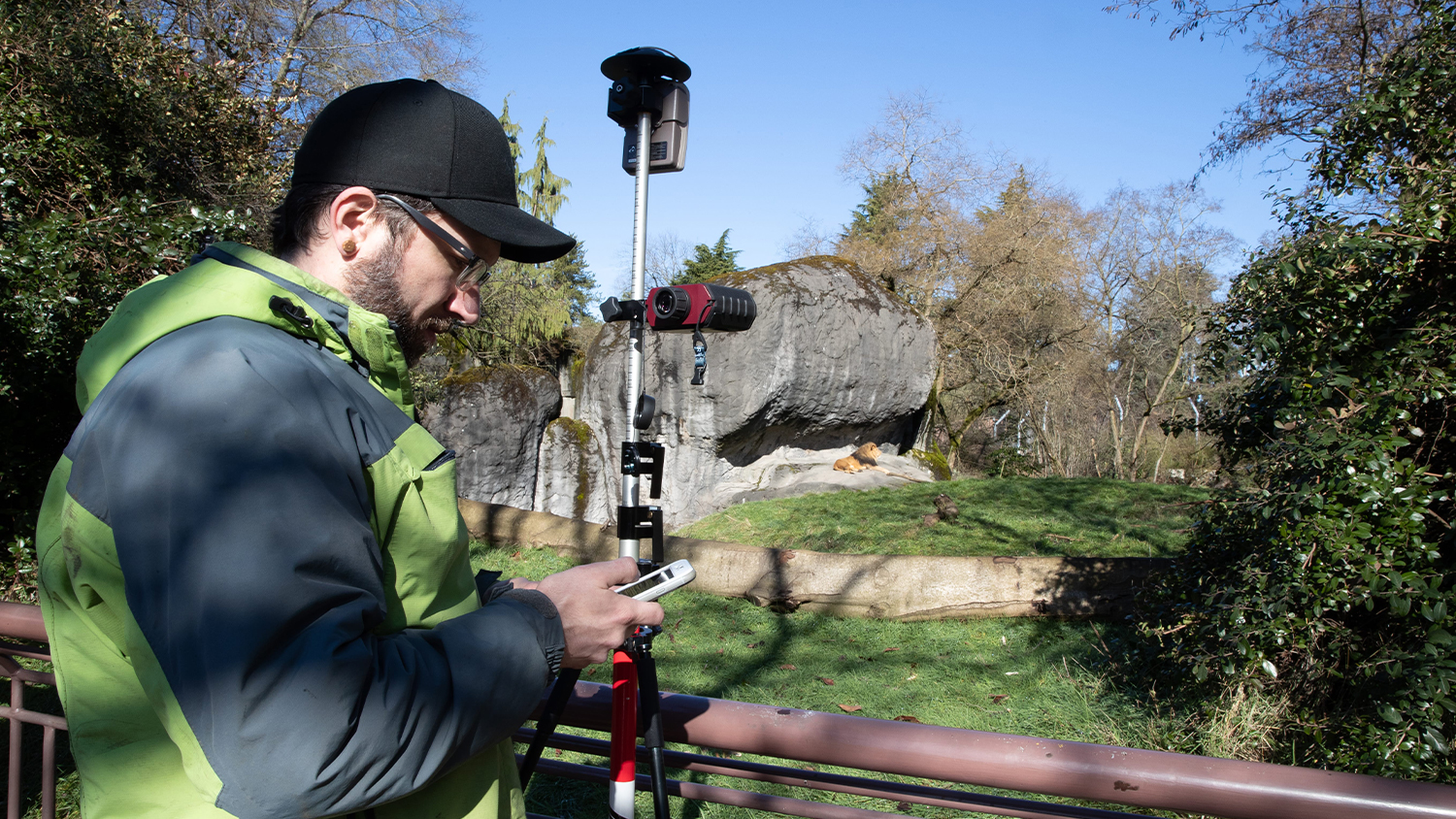
Block mounted his Arrow 100 antenna to a 15-foot telescoping survey pole. The rod let him extend the antenna’s reach to achieve a better view of the sky in some locations.
But even a longer rod couldn’t eliminate the zoo’s biggest challenge: the trees Block wanted to map were obstructing the sky.
The Results: Laser Mapping Increases Accuracy and Protects Animals
“With the laser offset, I don’t have to guess where my points are now. I can actually get pretty close. Depending on how close I am to buildings, I can get as good as 20 centimeters.”
— Dann Block, Lead Gardener, Woodland Park Zoo

Next to the base of a big tree, of which Woodland Park Zoo has plenty, satellite signals would drop even when tracking all four global constellations, and the location point would “hover around a large area,” according to Block. If he could get away from the trees, to clearer skies, he could collect his data with higher accuracy. But to do that, he would need to be able to capture points from afar with a laser range finder, which would then feed the asset location into Collector.
Block had seen that Eos introduced a new, high-accuracy “Laser Mapping with ArcGIS Collector” solution, so he reached out to the company through its online contact form to see if Eos could recommend a good laser range finder.
“I would like to find a laser range finder to map our gardens and infrastructure,” Block wrote, “most of which is under dense canopy cover.”
Eos recommended the TruPulse 200x from LTI, which would allow Block to map trees, valves, and other targets from hundreds of feet away while retaining his submeter accuracy. It also worked seamlessly with Block’s existing Collector app running on iOS®, as well as his Arrow 100.
He ordered the TruPulse 200x and started laser mapping the trees and infrastructure that were located under other trees and buildings. His accuracy was usually about 20 centimeters.
“It’s a great tool to have,” he said. “When I’m in dense canopy and I have all these trees, I can just pop back out, get a line of sight, and take my location point from there.”
The zoo also purchased LTI’s TruPulse Foliage Filter, a lens that filters out foliage and other obstructions so only the target is acquired. That helped Block take points under dense shrubbery, which happens to be where irrigation valve boxes are usually situated.
“With the laser offset, I don’t have to guess where my points are now. I can actually get pretty close,” Block said. “Depending on how close I am to buildings, I can get as good as 20 centimeters.”
The laser offset also allows Block to take extra precautions for the animals’ safety. If he were to enter each exhibit to collect data, the animals would have to be kept in their sleeping quarters.
“This usually disrupts their daily routines, so we avoid this whenever we can,” Block said. “It also involves lots of coordination between departments.”
The range finder comes in handy in inherently challenging places as well, where standing to capture data would be hard. This includes roof edges, moats, and fences surrounded by thorny bushes.
“The laser range finder is useful anywhere safety is an issue for our workers or equipment,” said Block.
A Robust Map for Employees and, Eventually, the Public
“Most importantly, the map will be available to any employee in ArcGIS Online to locate infrastructure and related information in the field.”
— Dann Block, Lead Gardener, Woodland Park Zoo

So far, Block has mapped 10 percent of Woodland Park Zoo’s infrastructure and gardens. He began by mapping polygons of garden beds and exhibits so he could create pathways that hint at where valve and electrical boxes might be.
“We can populate where our valve and electrical boxes are based on the edges,” he said.
Meanwhile, he’s working to figure out how to link digital scans of existing as-builts to the data in ArcGIS. This will enable field crews to pull up the history of any point in the field through Collector, including for buried assets.
“When our field crews are using Collector, they can see what we’ve collected so far and also look at the as-builts to have an idea of what the underground should look like,” Block said. “We can also populate the map with photos, links to work orders and work history, as-built maps, historical information, and more.”
The first milestone for Block will be completing the basemap for the entire zoo within the ArcGIS for Parks and Gardens Data Model. It will show polygons of garden beds, exhibits, buildings, and pathways, as well as points that represent trees and other infrastructure. Block has also received requests to add other data to the map, such as storm water runoff.
Block and the zoo’s facilities teams now envision that their crews—including outdoor and indoor horticulture specialists, maintenance workers, pool operators, plumbers, electricians, carpenters, and general laborers—will use Collector on their company-issued phones to look up accurate information as they go about their work.
“Most importantly, the map will be available to any employee in ArcGIS Online to locate infrastructure and related information in the field,” he said.
Block expects the project to take several years to complete. But once it’s done, he also anticipates designing that garden app that got him started.
“We can eventually use this to document the garden layouts and plant locations, which could be incorporated into an app that the public can access,” Block said.
This story originally appeared in Esri’s ArcNews magazine. Some photos and quotes have been edited or re-emphasized.

Download a PDF of this case study in ENGLISH.
You May Also Like One of These Success Stories

GNSS Data Helps National Park Clear Snow from Unmarked Alpine Roads
National Park Service is using Arrow Gold® RTK GNSS receivers at LAVO national park to clear tens of feet off alpine roads with cm accuracy.

Field Data Collection Improves Access to Québec Mtn Bike Trails
Velo Quebec uses Arrow 100® and ArcGIS QuickCapture to quickly map bike trails at speed. The data helps ensure land owners maintain the trails.
