Getting to Know Rahway, New Jersey
About 22 miles southwest of New York City, 30,000 residents call Rahway, New Jersey, home. The Department of Code Enforcement and Engineering & Land Use Department are responsible for the engineering, design, and inspection of everything from properties to rights-of-way. Within the Engineering & Land Use Department, the Engineering Division, in particular, regularly responds to internal and external information requests. Recently, the city created an initiative that would digitize and streamline such requests.
Adopting GIS to Modernize Response to Records Requests
Decades ago, Rahway’s engineers captured high-quality information while mapping the city’s sanitary sewer and stormwater systems, but there were challenges because the engineers did so on paper forms called “flat files.” Over time, these files became difficult to update, such as after routine work was completed by Rahway Department of Public Works (DPW) or capital inprovement projects. The flat files were also difficult to maintain and share.
“The original engineering flat files contained terrific information,” said Jacqueline Foushee, former City Engineer and current City Business Administrator. “But over time, they became difficult to interpret, share, and update. Each time they were fed in a scanner, for instance, their quality deteriorated. Our goal was to get away from that, and we had always envisioned having an enterprise GIS [geographic information system].”
Foushee received approval from Rahway mayor Raymond Giacobbe to implement an enterprise GIS throughout the city. Foushee identified the city’s upcoming municipal separate storm sewer system (MS4) inspections as the ideal project to start capturing information with the city’s GIS.
Ditching Paper for Mobile Maps
The city is required to inspect its stormwater outfalls every five years as part of the MS4 Tier A permit. The New Jersey Department of Environmental Protection (NJDEP) required all MS4 Tier A municipalities to map and submit their stormwater outfall locations in a digital GIS format by December 2020. Realizing the opportunity to populate Rahway’s new GIS, Foushee sought the help of Esri partner Colliers Engineering & Design (formerly Maser Consulting). With vast experience in municipal and utility GIS, Colliers was prepared not only to perform the inspections, but also to map the entire stormwater and sanitary sewer system in the process.
“Prior to this, the information lived either on paper files or in a CAD system that wasn’t geospatially tied to reality,” Colliers Project Manager Michael Kolody said.
In the past, Colliers had used ArcGIS Collector to map utility systems within enterprise geodatabases. But for this project, Colliers staff saw an opportunity to migrate to the new ArcGIS Field Maps mobile application.


In addition to the data-collection capabilities of Collector, Field Maps offered a mobile-worker tracking capability. Colliers staff members activated two supplemental tracking licenses, which allowed them to track their GIS technicians’ real-time locations. This added efficiency and safety to their process.
“In the past, we might not have known if we had mapped the assets on a street or if there were simply no assets there,” Kolody said. “With Field Maps, we now have that tracking record to say that, yes, someone had surveyed that street and there was nothing there. We can also see where each technician ended their day, which provides an extra layer of safety and monitoring.”
Training the two GIS technicians, who had already used Collector, took just a few minutes. A third, new employee was trained in under an hour.
“There were more similarities between Collector and Field Maps than I expected,” Kolody said.
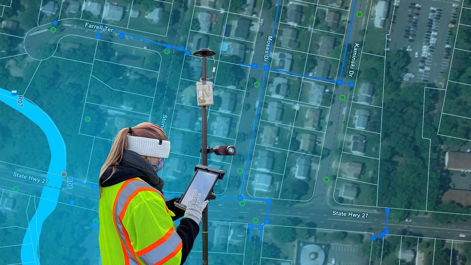
The Colliers GIS team installed the Field Maps app on Apple iPad®s. Colliers chose iPad as its standard GIS data-collection tablet because of its familiar user interface as well as its stability in the field.

To ensure that assets were collected with six-inch accuracy or better, the technicians used Bluetooth to pair Eos Arrow Gold® Global Navigation Satellite System (GNSS) receivers to the iPads running Field Maps. Because the data collection took place in the northern part of New Jersey, the technicians could easily log in to the New York Department of Transportation (NYDOT) public real-time kinematic (RTK) network to receive the survey-grade, satellite-based location corrections for the Arrow Gold® receivers. Ninety-five percent of the data was captured within six-inch accuracy, while an impressive two-thirds of the collections had accuracy within one inch.
“The combination of accuracy from the Arrow Gold®, the seamless integration into ArcGIS Field Maps, and the iPad’s user-friendliness just made this an easy-to-adopt mapping solution,” Kolody said. “It’s a solution our mobile teams actually like to use.”
About 130 storm drains located on the busy eight-lane Route 9 right-of-way were collected using the Eos Laser Mapping™ solution for ArcGIS. The solution included the Field Maps app, iPads, the Arrow Gold ® GNSS receiver, and a TruPulse 200X Laser Rangefinder from Laser Technology, Inc. This allowed a GIS technician to capture the storm drain locations from a safe distance off the highway while retaining accuracy.

After mapping the locations of the stormwater outfalls in Field Maps, Kolody’s team performed the inspections required for the MS4 Tier A permit, using a form the team created in ArcGIS Survey123.

Providing a Flood of High-Quality Data to the City’s GIS
In just a few days, one GIS technician was able to capture the majority of the 4,750 municipal surface assets (2,867 storm drains, 1,718 stormwater catch-basin inlets, and 160 outfalls). On a few occasions, two other GIS technicians assisted part-time.
Colliers also set up a dashboard, created with ArcGIS Dashboards. The dashboard enabled Foushee’s team to see the data-collection progress in real time.
“The dashboard was such a great addition,” Kolody said. “It allowed Jackie [Foushee] and her team to be able to review and visualize our progress in real time.”

After mapping all surface assets, Colliers used the data from the original paper surveys to digitize the subsurface assets (e.g., gravity mains) in the GIS.
“The information was good enough that we didn’t have to open [storm drains] to collect the data,” Kolody said. “This was the most cost-effective approach.”
Meanwhile, Foushee’s team digitized the legacy flat files and made them searchable by keyword (e.g., street name) so that the team can always retain a copy of the historical surveys within the new GIS.
The next phase will be to create web maps that expose the data for internal and external use.
“Now that we have a complete, geospatially accurate inventory of the stormwater and sanitary sewer system, our next step is to explore the best practices for sharing this information,” Kolody said.
Foushee is excited to see the efficiencies gained from other departments’ accessing information via web maps, rather than having to call and request paper file scans or manual updates.
“This will let our public works department [staff] access and update data themselves, without having to call Engineering,” she said. “We can do the entire information exchange through web maps, which is one less step in our manual interactions. That’s going to speed things up, which is great, especially when you’re facing an urgent public works event, such as a sinkhole repair.”
Foushee expects Field Maps to replace all paper-based mobile workflows. Also, Colliers is exploring how the new smart form capability in Field Maps might be used for routine DPW maintenance.
Moving forward, Rahway will require all plans associated with awarded contracts to be submitted in GIS format. The long-term vision is to be able to expand the enterprise GIS beyond the Engineering Division and DPW. There are talks, for instance, of informing the public of scheduled road work, and sharing water data with the Department of Police, Fire, and Municipal Court.
We want to migrate completely off our legacy software systems and onto GIS. If we can have the true, absolute locations of all the things we track, then it will be easier for all of us to do our jobs. That’s going to make a real difference.
This story was originally published by Esri. View the original article here.
Download a PDF of this article in ENGLISH.
You May Also Like One of These Posts

Customer Spotlight: Michael Kolody Serves Clients with Cartography
Mike Kolody turned his childhood love of cartography into a career. Today he helps clients modernize mobile GIS and GNSS mapping workflows.

Wilmington Achieves Real-Time As-Builts with ArcGIS Field Maps and Arrow GNSS Receivers
Previously it took 3rd-party contractors 1+ year to deliver Wilmington’s CAD as-builts. Now with ArcGIS Field Maps and Arrow GNSS, it’s near real time.
