Dmitri Bagh is committed to putting the “real” in augmented reality (AR). As a Scenario Creation Analyst at Safe Software, he validates data visually through AR models that can be viewed live in the field. To ensure accuracy of these models, he sought out a high-accuracy GNSS receiver. After discovering the work he posted on social media, Eos decided to follow up to learn more.
Through research, testing, and passion, Dmitri is helping to pave the way for visually powerful, high-accuracy data collection with AR. Read below to find out more!
1. Why are you passionate about your job?
I am proud to work at Safe Software, home of FME, a data integration platform with geospatial capabilities. My role is to find and explore realistic user scenarios and then present them to the world – it can be anything from point clouds and medical imagery transformations to computer vision and games.
As a geographer, I was really happy to discover a new canvas for my experiments — the world around us. With augmented reality, I am no longer limited to my computer screen. Suddenly, I have a chance to work with spatial data that combines traditional sophisticated cartographic methods with the power of 3D visualization at a large scale — a scale of 1 to 1, to be exact.
Augmented reality is all about our world, everything that surrounds us, but with extra context. One of the first experiments I made was placing augmented furniture on my freshly built deck, and that worked beautifully. A decision was made right away.
I began augmenting the world with all kinds of things — castles of the past and office towers of the future. I visualized non-material things, like flight paths and air quality. I invented portable holes and to allow us to digitally see through walls and under the ground. Why am I passionate about my job? It is the possibility to innovate with endless creative and exciting ideas for AR.
2. How did you first find out about Eos Positioning Systems’ GNSS products?
Many of our customers who began experimenting with AR are concerned about the accuracy of model placement. The built-in GPS receivers in mobile phones and tablets have very low and inconsistent accuracy. We knew, in theory, that using a high-accuracy GNSS device should solve the problem. However, without personal experience, we didn’t feel it would be right to tell our customers: “just connect a GPS receiver to your phone, and it will all work.”
That is why we decided to conduct an experiment with an external GNSS receiver. I did not have any particular brand in mind, so I opened dozens of tabs. One of them was the Eos website.
My brother, a surveyor with many years of experience, told me it might be hard to find a vendor that easily connects to iOS®, which is the platform we use first to develop and test new AR functionality. The ability of the Arrow GNSS receivers to work with both iOS and Android devices directly was a decisive factor for us.
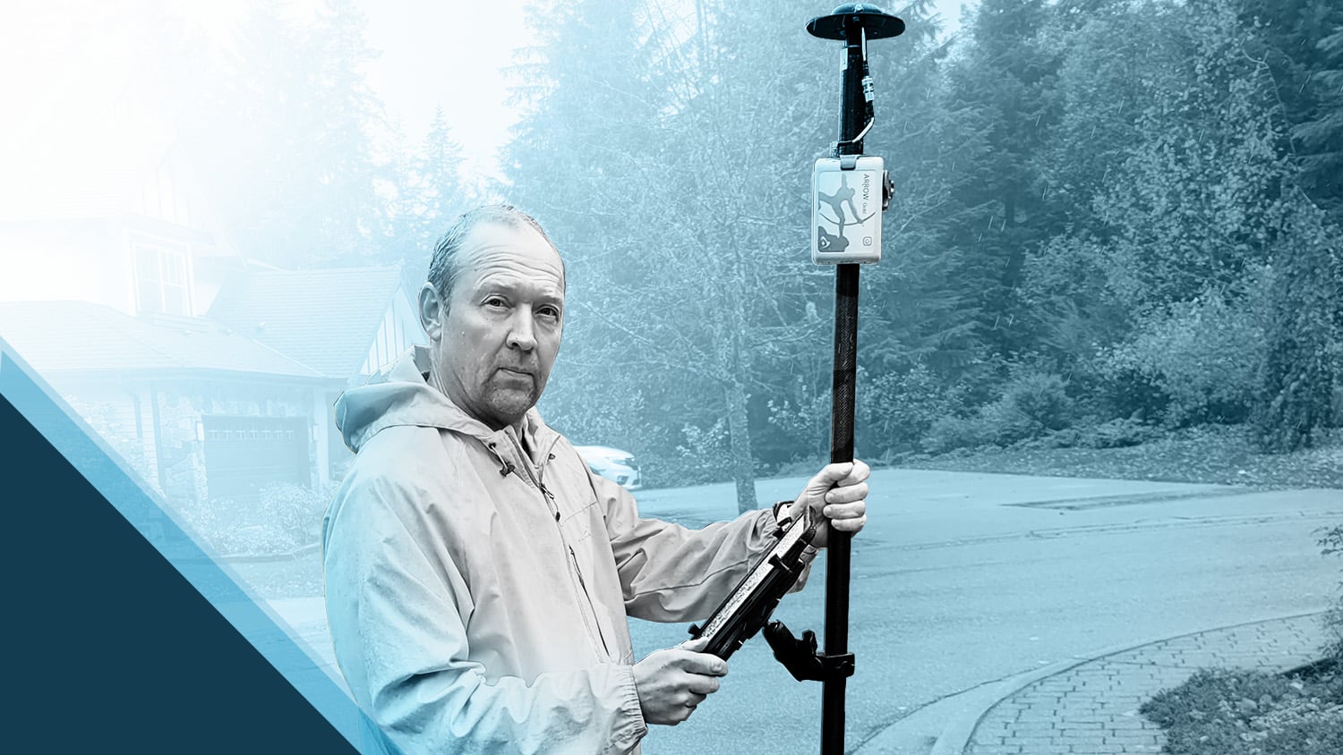
I contacted Eos and explained our situation. Very quickly, in just a few days, we had the Arrow Gold® GNSS receiver in hand to start testing our AR app.
3. What do you use Arrow Series® GNSS receivers for?
We had two goals. First, we wanted to know whether it was possible to use a high-accuracy receiver for AR model placement with FME AR, our free app. FME AR allows users to interact with their data in the context of the real world. We decided the exploration of underground infrastructure and other city assets would be a practical scenario.
Augmented models can easily appear 5-10 meters away from their true location, which is not acceptable for a lot of applications. The app allows manual model adjustment on the screen, but matching the model to the real world is a cumbersome process requiring training and good knowledge of the area. Using the Arrow Gold® receiver fully eliminated the need to adjust model location on the XY plane. Additionally, we also were able to solve the low accuracy of the compass in the mobile devices.
Our second goal was testing data collection with FME Data Express which allows running transformation processes in FME cloud. For this scenario, we compared an Arrow Gold® receiver connected to an RTK network against a variety of internal/external GNSS and GPS devices. The results were very telling.
4. Do you have a favorite experience or memory from your projects with Eos Arrow?
Somehow, I picked the worst two weeks for testing the receiver. We had several days with extreme weather conditions, but the last day (Halloween!) was perfect. It was warm and sunny, and everything just worked. We generated several models in different parts of the city, and they sat wonderfully. We tested a new orientation mode, which allows us not to use the mobile phone compass, and it worked perfectly.
5. Do you have a favorite feature of Arrow GNSS receivers?
I really like that all the work I have to do with the receiver is to press the power button. The rest I can do on the screen of a mobile device. Working with an iPad Pro® in the field is a real pleasure, so having all the settings and status messages in Eos Tools Pro was a significant advantage for me. Moreover, even on the iPad, only minimal interactions are needed from my side. I just turn on RTK stream, and check that the unit is delivering the accurate coordinates so that I can concentrate on working with our apps. This is exactly what I expect from a device — it should work invisibly and deliver the best user experience.
6. Is there anything we didn’t ask you that you’d like to share with us?
When I decided to learn more about Eos, I checked the company’s Instagram account, and was surprised to find a post with a picture of a virtual world I made about a year ago. At that time, I was helping Jim Casey, a GIS Specialist from the University of Denver, with creating the virtual and augmented representations of Amache, a WWII internment camp for Japanese-American citizens. This was conducted as a part of the University of Denver Amache Project.
Jim used an Eos Arrow Gold® receiver for data collection, but at that time, I didn’t pay attention how the field data for the project was collected. This was the first time I realized I indirectly shared a contact with Eos. I used the results of the data collection in my part of the project, while Eos worked with Jim on the “Augmenting Amache” ArcGIS StoryMap. I find it fascinating how different pieces of the mosaic came together.
The pandemic changed a lot of plans for everyone, and Jim has yet to find a chance to try the AR model at Amache, but we still want to write the next chapter in this story. We really would love to see an augmented model of Amache placed where it used to be. This is a difficult part of our past, which we have no right to forget. Now, we can tell this story with new technology.
Explore Related Success Stories

Mapping Amache Internment Camp with High Accuracy
Arrow Gold for Ground Control Points: Over 110,000 Japanese Americans were interned in WWII. One man is using GIS, GPS, and AR to make sure we remember.

Customer Spotlight: Jim Casey combines GIS with philanthropy
In our Sept 2020 customer spotlight, Jim Casey shows us how he is putting his Arrow Gold® GNSS receiver to good use with his drone and AR.
