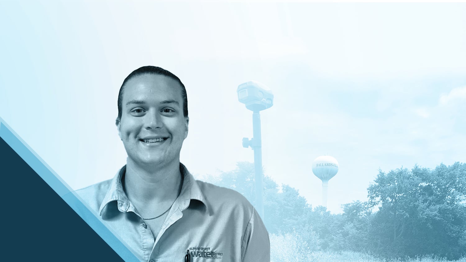
Garrett Black didn’t always think about what it takes to make clean water flow. Like many, he used to turn on the tap without giving it much thought. But when he joined Kentucky water utility Oldham County Water District (OCWD), everything changed.
As a Water Service Worker at OCWD, Garrett quickly discovered the immense talent, teamwork, and technology involved in providing safe drinking water to the community. Inspired by the critical role maps play at OCWD, he dove into GIS work with passion and purpose. Today, Garrett creates and uses high-accuracy maps daily, honing his skills with cutting-edge location technologies including ArcGIS®, Eos GNSS receivers, and Skadi Tilt Compensation™ to better serve the OCWD community.
For Garrett, mapping isn’t just a technical task — it’s a way to make a meaningful difference. Keep reading to learn how Garrett’s dedication is transforming water services for his community!
1. Why are you passionate about your job?
When I was a college student looking for a line of work I could dedicate my life to, I always wanted a career that would allow me to help and to provide a service to the greatest number of people possible. If anyone out there is looking for something similar, I would say that you will find exactly that by pursuing a career in the water industry.
Before I started working for the water district, when I turned on my shower in the morning or started my dishwasher, I always expected the water to be there. I hadn’t put much thought into the amount of work and the number of highly skilled people it takes to bring safe, reliable access to drinking water to my tap every day.

It did not take long for me to fall in love with the water industry. Within the first month, I gained a huge amount of respect for the men and women across our country that dedicate their lives and careers to providing the extremely valuable public service that is access to potable water.
What I am most passionate about and what drives me to come to work every day is the emphasis that my utility places on customer service. We strive to constantly keep our customers’ best interests in mind. Because we have such fantastic leadership that embraces innovation, our team is always looking for ways to improve our techniques and workflows so that we can provide this critical public service to our customers at the lowest possible cost. Interacting with customers is one of my favorite parts of my job. If a customer has a leak and can’t identify the source, I get a great deal of satisfaction when I am able to take the extra time and help them identify the problem.
2. How did you first find out about Eos Positioning Systems’ GNSS products?
During my onboarding process, there were a lot of references to our GIS department, and management made it a point to emphasize how crucial maps were to the success of our operation. Being a bit of a computer geek, I was surprised that I hadn’t heard of this technology before. I met with OCWD GIS Manager Kenny Ratliff, and he really got me intrigued to learn as much about this as I could. I remember how fascinated I was the first time Kenny pulled up the map of our system for me. With over 365 miles of pipe in the ground, our utility had an extremely accurate representation of its system on the computer screen. Before seeing that, I had assumed most of our maps were probably on paper, and for some utilities that is still the case. But here at OCWD, we are fortunate to have leadership who place a high emphasis on innovation and technology. With our Eos Arrow Series® GNSS receivers and ArcGIS Field Maps in particular, our field staff have everything they need in the palms of their hands to be far more efficient in performing their duties on a day-to-day basis.
3. What do you use Eos GNSS products for?
Every piece of infrastructure that is newly installed or has been excavated for repair or spot locates is mapped with high-accuracy location data from our GNSS receivers. Having every fitting, pipe, vault, and meter collected with sub-centimeter accuracy means that all service workers have access to a highly accurate representation of our system on their phones or tablets via mobile and web apps. Last year we made it a goal to collect points for every meter in our system. For about three months, service workers like me were out in the field performing meter inspections and collecting points. By the end of the year, we had successfully collected all 9,000+ meters in our system.
4. Do you have a favorite experience or memory from your projects with Eos hardware?
I know when I am doing this, I am helping to build a map that will be used by all my coworkers for years to come.
As I mentioned above, collecting points for all the meters in our system was a big accomplishment. It was hard work; there were many dozens of miles walked. But the sense of satisfaction we had when it was all over — seeing a map that is now a truly accurate representation of our system — was a great experience. I will say that this feeling of satisfaction is not solely reserved for the larger projects. I get a similar feeling every time I collect a point. I know when I am doing this, I am helping to build a map that will be used by all my coworkers for years to come.
5. Do you have a favorite feature of Eos GNSS receivers?
My favorite feature is a relatively new one that is available with the Skadi Gold GNSS receivers. The Skadi Tilt Compensation feature is incredibly beneficial, and for lack of a better term, is just really cool. Without tilt compensation, we always had to keep the pole level and keep an eye on the bubble to ensure the point collected was accurate. With the new tilt compensation feature, this is no longer the case. Not only is this feature great from an ease-of-use standpoint, but in some situations, it makes our work environment much safer. Trenches can collapse. Stretching to reach over the edge of a saturated trench wall can be a recipe for injury or worse. Now, with Skadi Tilt Compensation, when I am standing on the edge of an excavated trench and I need to collect a point on an exposed fitting, I can place the bottom of my range pole on that fitting at an angle from the side. Skadi Tilt Compensation will rectify the inaccuracy from my tilted position, and the point will still be accurate. We no longer have to stand on the edge of exposed trenches and try to level the range pole!

Similarly, I’ve always had difficulty collecting accurate points for fire hydrants. To get an accurate point, the GNSS antenna needs to be directly on top of the asset. Doing this without tilt compensation was not always easy, because you could not place the pole on top of the hydrant and still see the bubble to ensure it was level. With tilt compensation, we no longer need to bubble up — Skadi will do the hard work for us.
Skadi Tilt Compensation will rectify the inaccuracy from my tilted position, and the point will still be accurate. We no longer have to stand on the edge of exposed trenches and try to level the range pole!
6. Is there anything we didn’t ask you that you’d like to share with us?
I believe that all water utilities could benefit from using high-accuracy GIS. It is far more than just collecting points for a map. We have maps that are specifically built for tracking annual meter inspections, daily flushing, boil-water advisories, and service interruptions. All of these have built-in forms that can be edited in the field. The pen and paper can be left in the truck. The workflow and efficiency improvements using these technologies cannot be understated. I know that utilities have completed these tasks before this technology was introduced, but I have to say that I do not know how in the current day and age some utilities have not embraced the technological advancements that have so drastically improved workflow and efficiency. At my utility, we are working to provide the public service that is potable water at the lowest possible cost to our customers. The cost of inefficiency is high. The leadership here has gone above and beyond in embracing innovation and with our utilization of GNSS technology. We have made huge strides in keeping costs down for our customers, while also improving workflow efficiency as well as employee satisfaction.
Explore Related Content

Webinar: Beginners Guide to Mapping with High-Accuracy GPS, with NRWA and Esri
Industry experts and a real-life use case teach best practices for mapping water assets with high-accuracy GPS / GNSS.

5 Water Utilities Using Bluetooth GNSS Receivers
Five water utilities are using high-accuracy Bluetooth® GNSS receivers to transform their mobile data collection. Here’s how.
