In Maryland, Washington College boasts a rich and storied history. Founded with the endorsement and financial support of George Washington, the college maintains its legacy and excellence to this day. It particularly shines in its Geospatial Innovation Program (GIP), established in 2003 and currently staffed by eight dedicated GIS specialists. Among them is GIS and Cultural Resource Specialist Madison Kaye.
“We are a small liberal arts college on the eastern shore of Maryland,” Kaye said. “We have only about 1,000 undergraduate students and no graduate students, so the focus of the school is on the undergraduate experience. That’s something I really appreciate as a staff member, and I’ve heard from a lot of students that they appreciate it too.”
The GIP’s hallmark experience is its paid internships, which are open to all students, without prerequisites. This inclusive approach enables even freshmen to gain practical GIS experience. Each semester sees approximately 15-20 students undertaking a GIS internship, with a slightly smaller cohort of 7-10 students during the summer. Internship funding stems from real-world contracts and grants. For instance, the GIP has secured grants from the Maryland Highway Safety Office, Maryland Department of Transportation (MDOT), and nearby Delaware Department of Education.
According to Kaye, these internships not only provide valuable GIS experience but also offer students a deeper understanding of their surroundings beyond the campus.
“When you go to college, often you’re going to a place where you haven’t grown up,” Kaye said. “You don’t have an attachment to that place outside of college. So, I really like to get students off campus and into the local community with their projects. It gives them a sense of place, and they can feel at home in this place where they’re going to spend four years of their lives.”

From Campus to Canopy: College Geospatial Innovation Program Maps a Maryland State Park
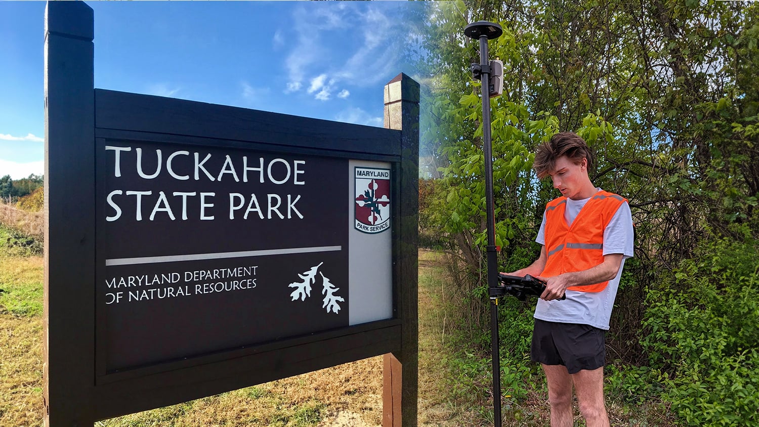
Located approximately 30 minutes by car south of Washington College is Tuckahoe State Park – a gorgeous, canopied recreation and camping destination. Since the COVID-19 pandemic in 2020, Tuckahoe State Park saw a 105 percent visitor increase. In 2023 alone, they welcomed over 210,000 day-use visitors and 17,000 campers. Upon arrival, many visitors seeking to use any of the park’s 19 trails request a printed map of the park.
“Many people who come into our visitor center are looking for a map that they can hold in their hand,” Assistant Manager Ashlee Reinke said. “Some people don’t want to rely on technology while they’re out recreating in the woods.”
Established in 1975, the park has not stopped adding to and updating its attractive hiking trails, though this has rendered the current printed visitor maps out of date. Over time, park staff had drawn in new trails to make the map as accurate as possible, but last year, the team decided it was time to formally update the visitor maps.
“We wanted to both make sure our new trails were accurately reflected as well as update the locations of our amenities, such as cabins and accessibility bathrooms,” Reinke said.
Nearby, another state park had asked its local university to update its trail maps. This gave Tuckahoe State Park the idea to reach out to Washington College. The park had already partnered with the College on other projects, and ultimately got connected to the GIP. In February 2023, the first talks began between Kaye and the park’s teams, including Reinke and fellow Assistant Manager Jessica Conley.
“They had heard we could update their trail maps, and we said, ‘Yes we can!’” Kaye said.
In addition to updating the park’s printed map, Kaye’s team offered to also create an online map as part of the project, which would make the use of future interactive web maps and making updates easier. With this objective identified, the team proceeded to develop a plan of action.
In the Field: Two Students, GIS, and GNSS
In most instances, the GIP compensates interns for their contributions to client or grant-funded projects. However, the Maryland DNR, which oversees state parks including Tuckahoe, opted to directly pay the student interns for this project, while also providing the GIP with its own contract for staff work. This arrangement offered the student interns the flexibility to conduct mapping activities on weekends in addition to regular school days.
The project officially began in the fall semester of 2023 with Environmental Science major and GIS intern Jessica Borders. After Borders graduated in December, Environmental Science major and GIS intern Dyllan Bishop continued the project in the spring 2024 semester. Borders’ work focused on mapping trails and points of interest in the field, while Bishop primarily worked on the web and PDF map deliverables in the office.

In the field, Borders used Esri’s ArcGIS® Field Maps mobile mapping app on one of the GIP’s dedicated iPad® tablets. ArcGIS Field Maps allowed her to collect data with specific attributes, such as surface type, trail name, and blaze color (the color of trail markers). Borders took advantage of ArcGIS Field Maps’ continuous streaming feature, enabling her to map trails as line segments rather than capturing just individual points. She and Kaye developed a workflow wherein Borders initiated a line segment at the start of each trail, mapped continuously for about a mile while capturing a point at every 10 feet, with a repeat of this process after about each mile. This allowed her to take breaks as necessary, since the park’s trails almost all run several miles from the top to bottom of the vertically north-south oriented park.
“This was my first time using ArcGIS Field Maps’ streaming feature instead of just collecting points,” Kaye said. “So we learned together how to record continuous line segments.”
Because Tuckahoe State Park has a lot of dense canopy, using the integrated GPS of the iPads wasn’t good enough to meet the park’s desired trail accuracy level of 15 feet. So Kaye also trained Borders how to use the GIP’s Arrow Gold® global navigation satellite systems (GNSS) receiver. The Arrow Gold Bluetooth®-pairs to an iPad and replaces its native GPS with a much higher-accuracy location.
Borders and Kaye leveraged a local real-time kinematic (RTK) network to obtain differential corrections, necessary for the GNSS receiver to achieve high levels of accuracy in real time. The Arrow Gold streamed these differentially corrected locations directly into ArcGIS Field Maps, facilitating precise placement of trail lines on the map. Despite the park’s dense canopy, their accuracy ranged from 10 inches to five feet, well within the park’s desired accuracy.
“We’ve had the Arrow Gold for a few years now, and it’s the main GPS unit we use for field work projects,” Kaye said. “I did some test sessions with Jessica so that she knew how to set it up and put it together while at the state park.”
To maintain portable connectivity and sustain the RTK connection while syncing data from ArcGIS Field Maps to ArcGIS Online in real time, Borders utilized one of Washington College’s hotspot devices. This ensured seamless access to the captured data, which was immediately available in an ArcGIS Online web map at the office.
In the Office: Connecting the Data
In January 2024, Bishop took over as the project’s student intern. While Bishop collected some data in the field, the majority of his work occurred in the office, collaborating with Kaye and using the data collected by Borders.
Initially, Bishop stitched together Borders’ line segments to create complete trail lines and compared these with the legacy brochure map. Next, he calculated the total length of each trail and color-coded the trails in accordance with their blaze colors.
Tuckahoe State Park is unique in that there is an arboretum maintained by a nonprofit organization within the park boundaries. This arboretum has its own visitor center and a network of shorter but numerous trails within the park. The arboretum shared their trail maps, already in GIS format, with Bishop, so he could incorporate them into a unified trail map.
They had also mapped points of interest, such as bathroom facilities and camping spots, so Bishop symbolized these in the map as well.
“Having an accurate trail map is great. I have called the map ‘beautiful’ more than once. We are excited to get this version printed and into the hands of our visitors.”
In the Future: Results & Looking Ahead
In total, the team mapped 19 park-owned trails, including four previously unmapped trails. Along with the arboretum-owned trails, the final web and PDF maps contain a total of 42 trails and pathways in Tuckahoe State Park and Adkins Arboretum.
“Having an accurate trail map is great,” Reinke said. “I have called the map ‘beautiful’ more than once. We are excited to get this version printed and into the hands of our visitors.”
In addition to printing the map for visitors, there are discussions to make the map digitally accessible online as well as update in-park bulletin maps.
“We went into this project needing just our printable map updated, but we’ve discussed posting this to our website and even putting QR codes in the park for quick access to the digital version,” Reinke said. “We can certainly consider doing this in some of our more heavily used campgrounds.”
Meanwhile, Kaye hopes this project could inspire other nearby parks to update their maps.
“Hopefully we’ll be able to map other state parks in the area,” Kaye said.
Looking ahead, the team is exploring the possibility of mapping the park’s waterways, providing information to visitors interested in kayaking or using small boats within the park.
For more information on the Geospatial Innovation Program at Washington College, click here.
For more information on Tuckahoe State Park, click here.
You May Also Like One of These Success Stories

Field Data Collection Improves Access to Québec Mtn Bike Trails
Velo Quebec uses Arrow 100® and ArcGIS QuickCapture to quickly map bike trails at speed. The data helps ensure land owners maintain the trails.

GNSS Data Helps National Park Clear Snow from Unmarked Alpine Roads
National Park Service is using Arrow Gold® RTK GNSS receivers at LAVO national park to clear tens of feet off alpine roads with cm accuracy.
