Synopsis: Arrow Gold® and ArcGIS QuickCapture for Vineyard Mapping
How do you map half a million vines accurately and efficiently? That was the challenge faced by one premium California vineyard. Find out how ArcGIS QuickCapture and an Arrow Gold® GNSS base station/rover configuration became the ultimate GNSS solution! This presentation is approximately 20 minutes long and includes the cost/benefit analysis of using cloud-based RTK identification versus placing individual barcodes on each vine.
A Background in an Evolving Industry
Eric Gakstatter
[Start transcript]
Hey everybody, it’s great to be here to talk to you today about high accuracy GNSS. My name is Eric Gakstatter from Discovery Management Group.
Just by way of background, I’ve been in the high-accuracy GPS business for about 30 years now. I started way back when high-accuracy GPS was really expensive and really not that accurate compared to what we have today.
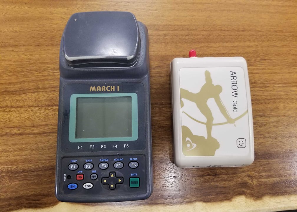
I was a product manager back in the 90s creating GPS mapping systems. Back then, real-time corrections really didn’t exist. Post-processing was the only way to get down to “high accuracy,” and at that time, high accuracy was sort of in that two to five-meter range. You had to collect data for tens of seconds or minutes and then go back and post-process, and sometimes there were headaches with post-processing because it wouldn’t work. There was this whole overhead that you had to go through to get the results that you were looking for and today, it’s so easy to just turn on a receiver (such as the Eos Arrow Gold®, pictured here) and get centimeter positioning just in a few seconds.
So it’s an amazing time; GNSS has really transformed over the last few years and so with respect to my talk today, this is a great example of a project that’s pulling together some really neat GNSS technology and some really neat Esri technology that we haven’t seen implemented before. In this particular case, it’s applied to precision agriculture, but you could apply this to other types of industries across the board that have a requirement for high-accuracy GNSS. I really like to talk about this project because it encompasses everything from high-speed, high-accuracy data collection to data communications in a rural area that doesn’t always have cell coverage. So in a way, it’s one of the most leading-edge precision agriculture applications that we’ve seen. The title of my presentation is efficient, Centimeter-Level GPS Data Collection and Management on a Vineyard.
The Challenge: Identifying 500,000 Vines Efficiently and Accurately
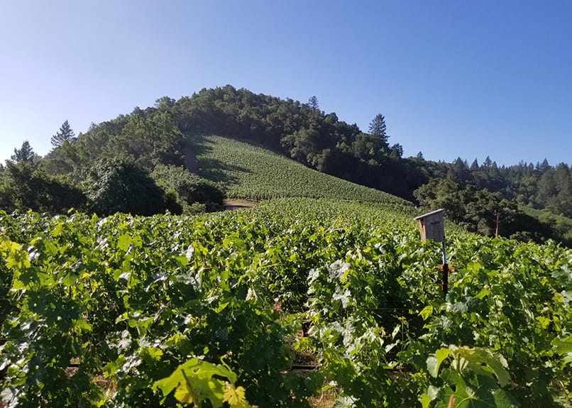
So the challenge when the vineyard approached us was, how do we create an efficient data collection and management system for a half a million vines? So, the first question you might ask is, “Why do you want to monitor or track each individual vine?” Well, they’re really interested in the highest quality end product that they can produce, and they actually treat each vine as an asset. They also perform an inspection on each one periodically and annotate its condition. Various problems may exist, for example, if a vine is not producing — this might be due to irrigation or drainage or disease or something along those lines.
In the past, they used a paper-based form, and you can imagine how difficult it was walking between rows of grapevines and having a tally sheet that you mark as you walk down the vine rows and then try to compile that data and make sense of it. If it was 50 vines, you could sort of keep track of that in your mind but with the half a million vines spread across different blocks in a geographic area, that becomes a very laborious and difficult task.
So the first task of this challenge is, how do we identify each vine? If I need to identify a vine and apply some treatment, it needs to have a serial number or some other identifier so that we can effectively communicate with the farm team on which vine we’re referring to. There were two methods of vine identification that were being considered, and the first one was to just attach a barcode, just like you would attach a barcode to a piece of clothing in a retail store and scan it when you go to the checkout counter. It’s the same kind of thing here; you could create an outdoor barcode for each vine and attach it to that vine and so when you’d walk up to that vine, you would scan it and that would bring up the record associated with that vine.
But when you start looking at the costs associated with that, it was immense. Outdoor barcodes that can survive in this kind of environment costs about a dollar a piece, and since we’re obviously dealing with over half a million vines, that’s half a million dollars just to have the cost of the barcode itself. That cost does not include the labor to install the barcodes, the scanning equipment, the barcode management software, and the whole workflow back into the system of record.
So we came up with another idea of how about we use centimeter-accurate GPS location to identify each vine. So if we use survey-grade GPS equipment, we can map a vine down to a couple centimeter level. So, we can do that actually fairly inexpensively compared to barcode technology. So the equipment budget was about forty thousand dollars, add on another ten thousand for installation and software and so on and you’re probably up to fifty thousand. So it became a significant ten to one cost savings over the barcode method.
Choosing a Data Collection System
So the next question was, “What kind of data collection system can we deploy that will allow us to efficiently map all these vines at the centimeter level?” When you look at the criteria, first of all, it must be very fast. The target was about three seconds per vine and if it takes any longer, it starts to make a big difference. It was a big concern for the vineyard if it ended up taking 15 seconds or 20 seconds per vine because that would make it a really labor-intensive task and it would become quite expensive labor-wise, especially since we were mapping out over half a million vines.
Secondly, it must be very easy to teach because there’s no dedicated mapping staff and so it could be a mixture of farm labor and office labor, whoever was available. Each one of these folks had to understand it because they had two or three systems and 12 people who were always on rotation and had to individually easily adopt and use the technology.
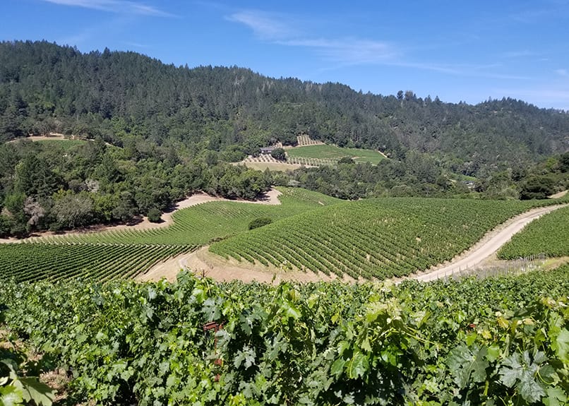
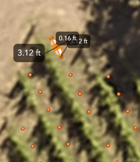
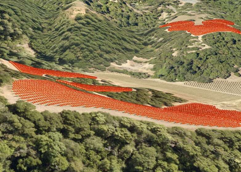
So, iPhone®s were the platform they were interested in using, just because they had made them available and they were used to iOS® already and wanted to easily use the technology. Just to give you an idea, on the far right is an image of the vineyard with the divine points laid on top and they’re spaced about three feet apart.
So if it takes you three seconds to get from one vine to the other, press the button and keep on moving, that was the idea and it must be reliable and work all day. This is a bit of a challenge in some scenarios with the iPhone due to its battery life, but we’ve got an extra battery pack that we include with those and it became a handheld type of ergonomic setup that I’ll show you an image of in a second.
So the third task was, let’s say we collect all this data of half a million points — how are we going to manage it? Because that’s part of the challenge. They had actually had the vines mapped before over the last decade, and they mapped it at the sub-meter level, which became a bit confusing because the vines are only separated by three feet and if you have a sub-meter receiver you can start to mix vines up really easily.
However, the biggest issue with the previous mapping effort was that there was no system of record. And what I mean is that there’s no big bucket or central bucket that they would load all the data into and manage it in that bucket. It was sort of spread out among different applications on different computers and then when you tried to combine them, they wouldn’t line up right and so the data management part of it really became an important task for the vineyard.
So, it must have spatial integrity so you’ll be able to deal with different mapping datums, and this system would become the spatial data system of record going into the future. It will be the gold standard. Again, it must be reliable and able to handle half a million records of vine data plus all the imagery behind it. It should also be able to handle future data, for example, inspection data, because it’s going to be an ongoing project.
This first phase was only just to establish the centimeter position of each vine. There will be an ongoing effort to inspect each vine and update the records in the database, thus, the data management system has to be powerful enough to accommodate today’s data and the data moving forward.
Using ArcGIS Online and ArcGIS Apps
We went through a pretty exhaustive search to find an optimal data collection and management platform, and what we ended up selecting was the ArcGIS Online platform. It is powerful enough to handle the volume of data we were talking about, it’s reliable, it’s a hosted service, and we’re not relying on local servers or our own computers if something bad happens, it’s safe in the cloud.
Esri also has a suite of mobile data collection apps and this actually became a really important concept for us. This was because at the beginning using a product like QuickCapture, which was the initial rollout application, allowed us to map the vines very efficiently. We ended up hitting that three to five-second target of mapping from vine to vine because QuickCapture is super easy. It’s a one-button operation; we could train people and in a matter of minutes, they’ll be able to use it.
QuickCapture was just the application in task one. If we look down the road with the inspection tasks, for example, there’s no doubt we’re gonna use the Survey123 form to be able to walk up to a vine or walk past it because they’re so efficient. They’re not going to stop and spend three minutes at a vine, they’re almost never going to stop walking. They’ll walk by a vine if they see a problem, they’ll hit a button noting that, and then and move on. So Survey123 is built really well for that; it’s got a data collection form and can have different selections in terms of an irrigation problem or drainage problem or a disease problem or whatever.
The third application is ArcGIS Collector, which is a really comprehensive mobile mapping software. We could envision using that to map the irrigation system, the drainage system in the vineyard, and the infrastructure. If any of you are farmers or operate agricultural operations, you know how much infrastructure is out there, and so the Collector application is really well suited for mapping those kinds of features.
The data from all three of these apps are fed into ArcGIS Online seamlessly. You don’t have to do anything different and they can all run on the same platform simultaneously. The vineyard chose to run it on iOS, but you could easily run all three of them on Android too. So that flexibility really made it the ideal choice for this application in terms of data collection and data management.
Collecting Data in the Field
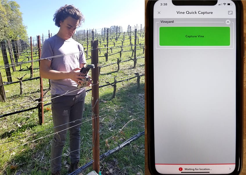
And just to give you some images of what this looked like — there’s the iOS screen, it’s got one button just to capture the vine location and actually we ended up moving that button down to the middle of the screen to make it a little more accessible to people. So the workflow is that the person would walk up to the vine, steady the antenna over the vine and take a second to do that, hit the capture vine button, it records the position in a second and then they move on to the next one behind.
There’s an iPhone mounted on this bracket, and you see the Eos GNSS receiver attached to the bottom. And again, this is all giving you survey-grade accuracy based on the location of that antenna. All you have to do is plum it over the top of that vine within a reasonable tolerance. So you can see the picture on the right — the operator is taking a shot of one of the vines and again, if we look at the timestamps between vines, we’re at about the three to five second range.
Data Management with ArcGIS Online
In terms of data management, once the data is collected, this is what it looks like back in the office. What’s interesting is that the vineyard could have two crews out mapping, and the data manager could be back in the office watching these points populate in real-time. It’s really a lot of fun to watch as they move along, and you can see how efficient they are. So I’m going to switch over to the live screen since what we’re viewing now is a screenshot. I’ll switch over to a live screen of ArcGIS Online, which is the data management platform.
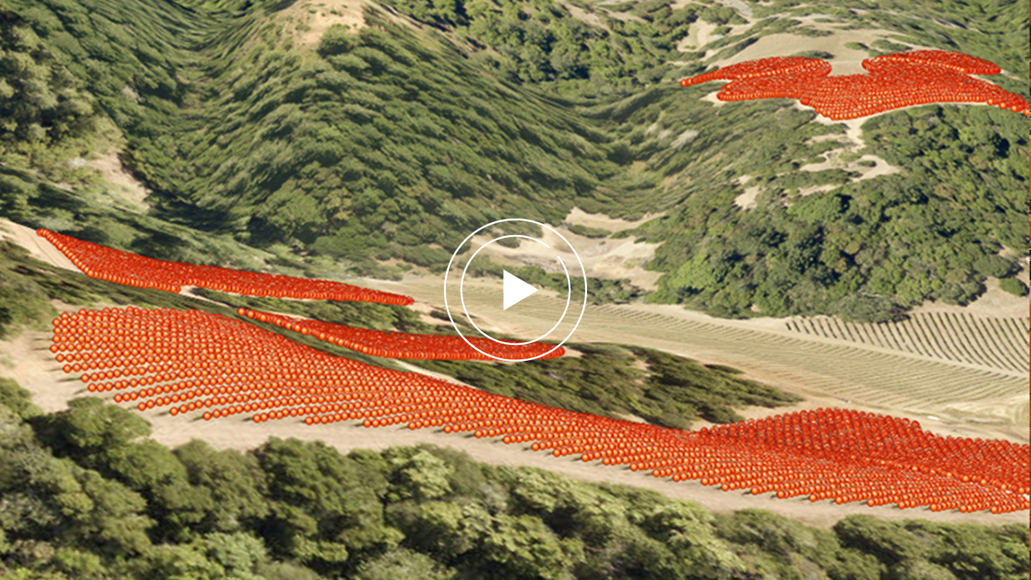
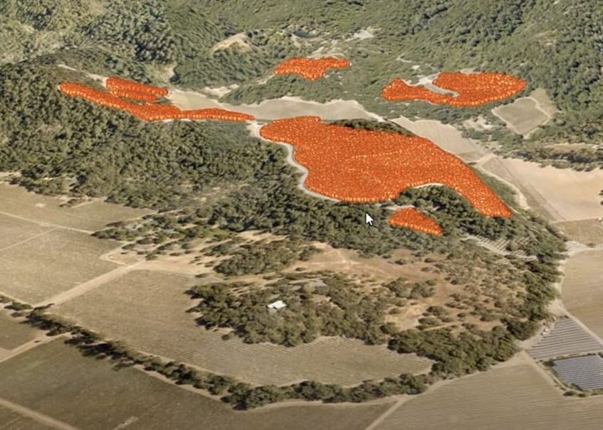
So this is a few blocks of vines in the vineyard, and I just tapped on the layer to display the vines and so each one of these points is a vine. And by the way, we’re sort of mid-stream into the project. It started in March, but they did collect 60,000 vines faster than they thought they would. It was just under two weeks.
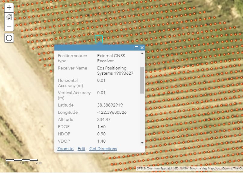
So I’m going to zoom in and just look briefly at what these look like. So this is one block of vines and you can see these are spaced out and there is an ID. Remember, the goal was to get a centimeter-accurate position for each vine and then have a row number.
If you can see, there’s a row number attached to each one, but if we just click on that vine, we have specific information about it, such as which receiver it was collected from. We didn’t want to be confused about whether the iPhone was using its own internal GPS or using the survey-grade GPS or Eos GPS. It gives us horizontal accuracy and vertical accuracy both at a centimeter. We have a row number, which is row number 23 for this one, and then a timestamp as well as an elevation too. So you could actually make an elevation contour map from this.
In fact, the vineyard was a bit concerned about the ArcGIS Online platform being too complicated, but they were surprised by the ease of editing data because invariably, you’re going to discover that people make mistakes in the field. Sometimes they’ll do a double tap on a capture vine and have two points on top of each other, but they found it’s really easy to go into ArcGIS online and edit that data. You can either call it or amend it.
The other beautiful feature is its visualization tool. So I’m going to switch to a 3D view of this to better show you. This is all within ArcGIS Online; you have a 3D scene viewer. It is an oblique view overlaid on a digital elevation map.
I’m going to sort of scroll around here and show you how really dynamic this is. It’s just amazing how cool this is to sort of visualize the topography and how it fits. There’s a lot of elevation change, and it’s probably three or four hundred feet of elevation change in all the blocks. This is only one part of the block, and it’s kind of neat.
If you look up here in the upper right corner, there’s one solo dot up there and that’s actually the base station for the GPS that’s broadcasting centimeter corrections down to the users here in the field. However, these brown spots are all over here by the base station are other vine blocks that are going to be mapped eventually. So this is really a great visualization tool for managers or project managers to be able to show this to executive management and have them really quickly visualize the value and the effort that’s going on here. So I’m going to switch back to PowerPoint presentation.
Conclusion
So, in summary, we’re deploying high accuracy Eos Gold GNSS receivers, and they were the most cost-effective method of identifying fixed assets versus the barcodes. Whether it’s the fixed assets, vines, buildings, irrigation pipes, drainage, utility poles, or whatever — the same tool can be used for all those different mapping applications.
Secondly, QuickCapture on a smartphone, or it could be a tablet, is a very fast data collection workflow that can be taught to entry-level labor for large-scale data collection projects like this.
Lastly, the really important piece is the ArcGIS Online component — it has proven to be a powerful and flexible system of record capable of handling a large volume of GIS data. The ultimate here is you really need a system of record that’s going to be permanent. They didn’t want to run into the same problem before where datasets ended up on different computers and different software systems, and when you try to combine those, it was just a mess. So this ended up being a great system of record for them moving forward.
Well, thanks for tuning in for my presentation, and if you have any questions, here’s my contact info. Stay safe!
[End transcript]

