Why Doesn’t My GPS Data Line up with My GIS?
As GNSS receivers become more accurate, more affordable, and easier to use with your smartphone and tablet computer, they are going to challenge the accuracy of your GIS database. How many times have you combined GNSS data with other GIS data only to see that it doesn’t line up?
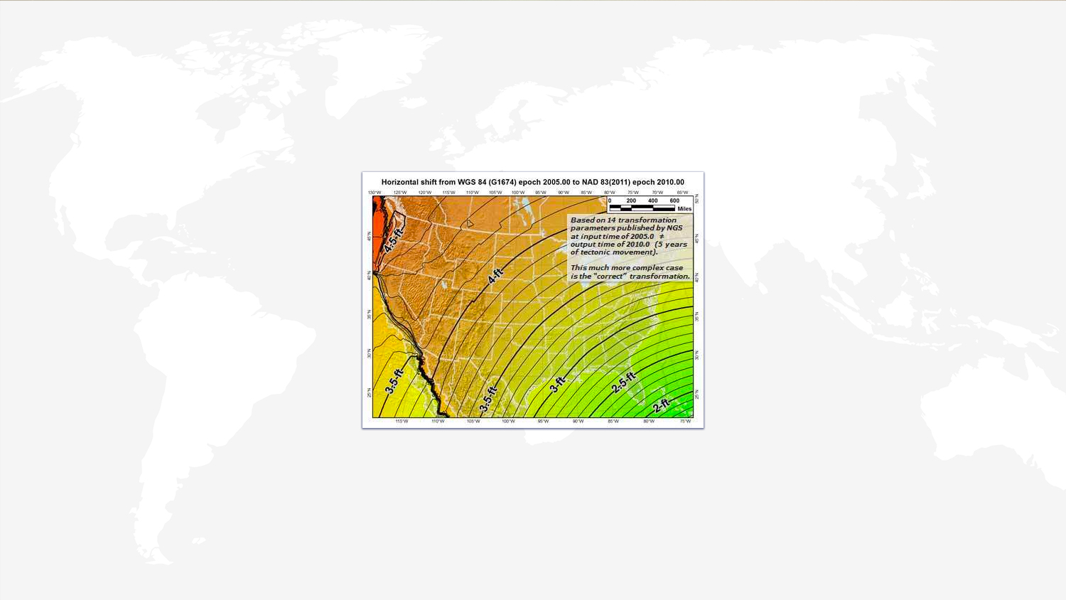
When your data doesn’t line up and it’s shifted a few feet/meters, it’s likely because the horizontal datums are different between the GNSS data and your GIS database. In North America, the common map datum is some iteration of NAD83. A common GNSS datum in North America is ITRF (similar to WGS-84). The problem is that these two mapping datums differ by ~2.2 feet to ~4.5 feet depending on your geographic area. Reference the following graphic from the US National Geodetic Survey (NGS). In Miami, FL, the difference is only ~2.2 feet. In Seattle, WA, it’s ~4.5 feet.

The Problem:
If your GIS database is referenced to NAD83/2011 and you’re collecting data with a “sub-meter” handheld or Bluetooth GNSS receiver that uses WAAS as a source of GNSS corrections, your data will be shifted anywhere from 2.2 feet to 4.5 feet because WAAS corrections are referenced to ITRF/WGS84.
This subject has been a constant technical support topic with users over the years. We’ve spent countless hours educating GIS users about the differences in horizontal datums.
The Solution:
Some applications like Esri’s Collector for ArcGIS and iCMTGIS Pro already feature on-the-fly datum transformation within their apps to handle this problem. We’re excited to announce that we’ve embedded a datum shift inside the Arrow receivers and Eos Tools Pro app so Arrows will output coordinates that will match NAD83/2011, ITRF/WGS84 or whichever datum you’d like. This is especially powerful for iOS® and Android mapping apps that don’t have on-the-fly datum shift capability like iGeoTrak, Fulcrum, Survey123, TerraGo, , and custom-built apps. It works with every iOS and Android software available today. Furthermore, it’s very useful for RTK (GNSS real-time, centimeter accuracy) users who want to have Google Earth, ArcGIS Earth, ArcGIS Online as a background map. Since RTK Networks are referenced to NAD83/2011 or other local datum, GNSS position appears shifted in those desktop mapping systems (because they are referenced to ITRF/WGS84).
A “How-to” guide is available in the “Learning Center” of our web site to provide an example on how to compute a datum XYZ shift for Eos Tools Pro.
Explore Related Knowledge Base Items

Eos Laser Mapping™: Configure settings in ArcGIS Collector
In this second Eos Laser Mapping video, you’ll learn how to set up Collector and Eos Tools Pro for laser offsets. Set alarms, orthometric height and more!

Eos Tools Pro: How to Compute Datum Offset Values
Knowing how to compute datum offsets is important for shifting between datums. The Eos Tools Pro app now supports computing datum shifts. Here’s how to use it.