Whether you work in asset management or location data in general, today’s modern mapping professionals require more reliable positioning than ever. This is why the Arrow Series® of GNSS receivers support signals from free, compatible Satellite-Based Augmentation System (SBAS). Ok. So what is SBAS?
What is SBAS?
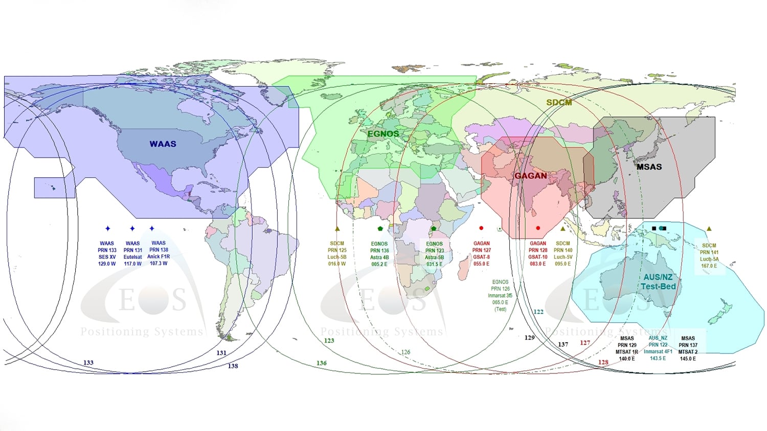
Satellite-Based Augmentation Systems (SBAS) have become the preferred method for real-time GNSS corrections. Today, there are four main SBAS’s that generally get talked about and utilized in the field. These include:
Is SBAS truly accurate and reliable?
WAAS, EGNOS, MSAS, and GAGAN were all designed primarily for aviation use. In aviation, reliable precision for approaches and landings is paramount. Lives depend on the reliability of these SBAS signals to ensure safe landing. The resulting integrity that SBAS offers outstretches any other sources of differential correction in the world. This is why SBAS has become the preferred method for reliable and accurate, real-time GNSS corrections. This is especially true of high-multipath environments, such as dense canopy, where GNSS signals may be obstructed.
Where can I get this accuracy using the SBAS signals?
Unlike LBAS, SBAS does not require close proximity to ground-monitoring stations to obtain high accuracy measurements. (LBAS, aka Local Based Augmentation Systems, include things like base stations).
All that you need to take advantage of free corrections from SBAS is
- to be within the broadcast ionospheric coverage, and
- to see one of the satellites within your regional SBAS constellation.

What occupation time is required to obtain submeter accuracy in obstructed environments, using SBAS?
One second.
No, we aren’t asking you to wait while we answer this question. It takes just one second to obtain submeter accuracy from real-time SBAS corrections in the field. That is, if you are using an Arrow Series® GNSS.
To do this, just follow a few simple steps:
- Power on your receiver.
- Allow 3-5 minutes of tracking — What’s happening during this time? First, your receiver will download the ionospheric map from the SBAS satellite. Next, it will transition this to a more accurate SBAS map. In addition, this will also allow carrier phase smoothening to engage. After this occurs, every fix collected in a multipath-free environment will now be submeter.
- Once you come out of a high-multipath environment, just wait 15-20 seconds before collecting a point.
All set!
How does the Arrow Series® take advantage of SBAS?
Unlike other receivers, the Arrow Series® utilizes SBAS signals to their full potential. On its own, the SBAS is quite accurate. However, the Arrow Series® offer an enhanced positioning accuracy by processing the SBAS signal.
In fact, the Arrow boasts 60cm 2dRMS (so 95%) accuracy using SBAS signals alone. Thus, by utilizing the SBAS signal to their full potential, the Arrow Series needs only SBAS to provide differential correction.
This unique and innovative method gives an Arrow user full-day operation in Differential Global Positioning Systems (DGPS).
The Arrow offers one more advantage: it expands the coverage area of an SBAS constellation. How? By further extrapolating the received ionospheric map from the SBAS, the Arrow can expand the coverage area of an SBAS constellation. This becomes especially useful in areas with marginal SBAS coverage.
What if my area lacks SBAS coverage?
As mentioned before, SBAS is not available in all areas of the world. For this reason, Eos offers the Arrow 200®. In an area lacking SBAS coverage, the Arrow 200 supports an Atlas® service correction so users can get real-time, submeter corrections in the field. In fact, the Arrow 200 was the world’s first GNSS receiver to support Atlas® on any device, including iOS®, Android, Windows, and Windows Mobile.
What is Atlas? Atlas is a subscription based correctional system to support high-accuracy data corrections in regions not covered by SBAS. The Arrow 200 supports multiple Atlas® differential correction services, including Atlas® H100, Atlas® H30, and Atlas® H10. (In addition, the Arrow 100 the Atlas® H100 submeter service.)
Are there alternatives to using SBAS or Atlas® services?
Yes. Additional, real-time receiver options can be purchased and field-activated. These include two optional LBAS solutions.
Option 1: Create a “Base-Station-Free Rover”
You can set up your Arrow receiver as a base-station-free rover. This means your Arrow will act as a known point in the field to correct against.
To do this, first set up your Arrow as a known point in the field. Send coordinates to the receiver to initialize, and you will be submeter-relative to the initialization/reference point for a 40-minute period. After 40 minutes, simply perform the initialization again — on the same reference point or another of your choosing.
Option 2: Use a Standard “Base Station-RTCM” Output
Your Arrow receiver remains on the reference point, from where it broadcasts standard correction. Meanwhile, a second Arrow receiver is used as a rover with a communication link between the two.
You can receive the same higher-accuracy local differential as above, but for location down to the subfoot or centimeter level RTK.
Summary: SBAS, Atlas®, and Arrow Series® Receivers for Real-Time Submeter Corrections in the Field
The Eos Arrow Series® GNSS receivers are SBAS, RTK, and Atlas® compatible. They are specifically designed to provide the highest level of performance in the GIS/mapping industry, at a breakthrough price point.
Furthermore, using patented and field-proven technology, the Arrow provides all-day DGNSS positioning under tree canopy, maintaining its accuracy for up to 40 minutes after the loss of an SBAS signal.
When more precise positioning than sub-20cm or cm-level is required, higher accuracy options are available in either real-time or post-processing methods. Both methods require an LBAS configuration (base/rover within a certain range of each other) for either fixed or float solutions or a real-time RTK Network with NTrip capability.
Explore Related Knowledge Base Items
RTK: Want Centimeter Accuracy on Your iPad® with Arrow GNSS?
In this article we show you how to get high-accuracy locations, including submeter and cm data, with your Arrow GNSS receivers on any iPad or iPhone.

What is Atlas®? Paid Differential Correction Service in Remote Areas
Atlas™ is a worldwide GNSS differential correction service, offering the most innovative base station-free corrections via L-Band satellites at accuracies ranging from meter level to a few centimeters. The Eos Arrow Gold GNSS provides worldwide decimeter positioning to your device.