
Ecobot, an Eos partner, is a software platform that enables swifter, more accurate environmental due diligence and permitting ahead of construction. Ecobot allows field teams to streamline their wetland delineations and related mapping. When combined with Eos GNSS receivers, Ecobot allows field scientists to capture extremely high-accuracy positions directly within Ecobot, along with associated environmental details about the features you are mapping. Because both Ecobot and Eos GNSS receivers are aligned with Esri’s ArcGIS platform; all the data you collect can be directly integrated into an ArcGIS ecosystem back in the office. Ecobot is also used by a growing number of firms in the AEC (architecture, engineering and construction) industry, as well as state and federal regulatory agencies, and the energy and utilities industries.
Deep Eos GNSS Integration
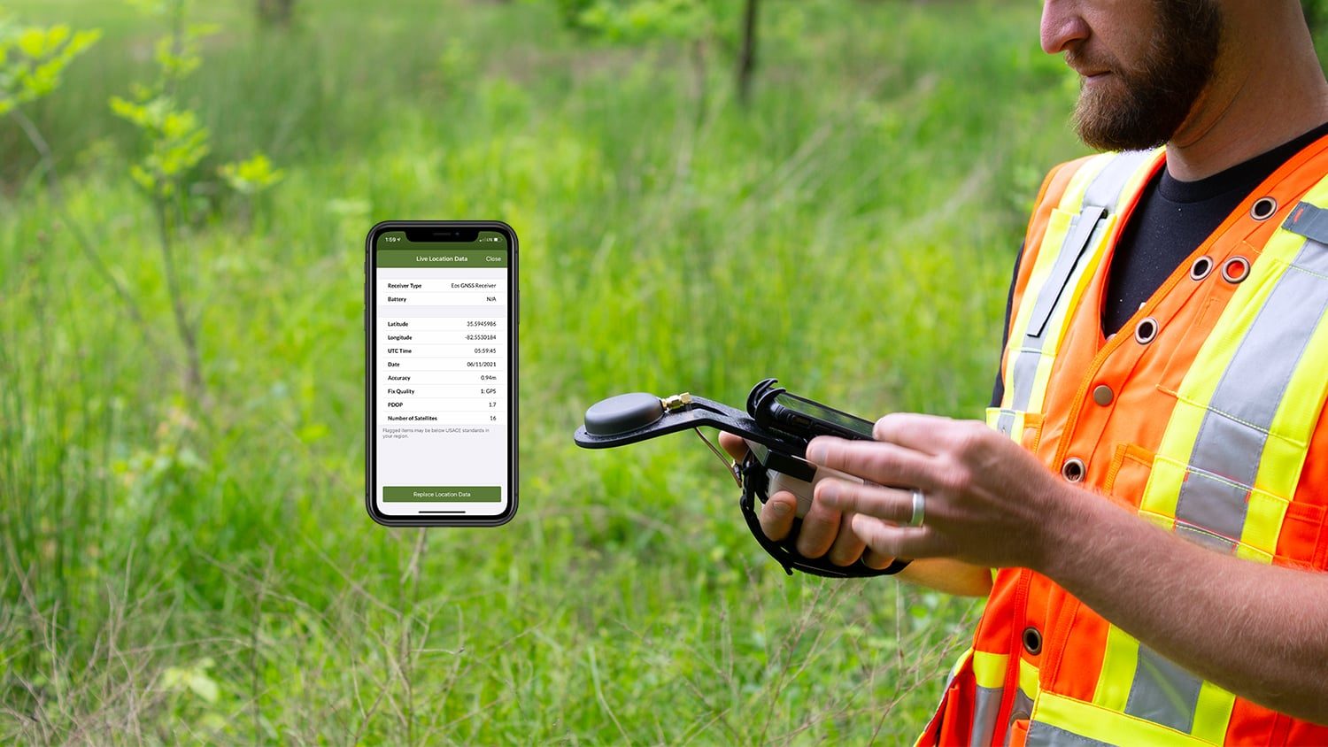
Ecobot provides a deep integration with Eos GNSS receivers, allowing for the capture, storage and delivery of GNSS metadata.
Stream RTK NMEA Data
Ecobot has deployed the Eos GNSS NMEA string library. This means you can achieve centimeter-level accuracy directly within the Ecobot app without having any other apps open.

Real-Time GPS Position Accuracy
Ecobot provides a live stream of position accuracy when you are adding or modifying a sampling point location.
Streamline Natural Resources Surveying
When combined with Eos GNSS receivers, the Ecobot app lets you perform highly accurate surveys of critical natural resources, such as wetlands.
What We Like about this Partner App: Ecobot
iOS® Optimized
Ecobot is instantly ready to deploy across organizations of any size on iPad® OS and iOS mobile devices.
Esri-Aligned
Ecobot uses the Esri ArcGIS Runtime SDK for the automation of ArcGIS-ready shapefile creation of collected sampling points, and includes integrated polygon mapping, available offline without any pre-project setup.
Environmentally Passionate
The Ecobot team is passionate about their partners, customers, and the work that both do. This makes them a great company to collaborate with.
Preserve Our Planet
Eos is excited to partner with Ecobot. Their energetic team demonstrates a clear passion for environmental resources management, and this enthusiasm translates into the brilliant wetlands-delineation application they have developed. Ecobot is an app we strongly recommend.
Success Stories with Eos GNSS Receivers and Ecobot

ESI increases wetlands mapping project profits by 20% using Arrow GNSS and Ecobot
Environmental Solutions & Innovations switched to Ecobot app and Arrow GNSS to replace a slow and cumbersome legacy mobile mapping solution.
More Info
Customer Spotlight: Scott Denham Navigates Wetlands with Mobile GNSS
Scott Denham uses Arrow GNSS and the Ecobot app for wetlands management projects. Learn what drives Scott to find the most efficient tech.
More InfoWhat Customers Say about Eos GNSS Receivers and Ecobot
I was able to get data from the field team at 2 p.m. on Friday every week. I could then complete quality checks and submit the entire week’s delineation results to the client by 5 p.m., rather than sorting through them all weekend. In addition, for the field team, using Ecobot to plow through the wetland delineations more quickly on such a large project was great for team morale.
Scott DenhamWetlands & Permitting Manager, Environmental Solutions & Innovations, Inc.
Other Apps You Might Like
