Two Rivers Utilities added hundreds of valves to its GIS as part of a new valve-exercising program, intended to reduce service interruptions and modernize valve-tracing on the Esri ArcGIS platform
The Organization: Two Rivers Utilities
Thirty minutes west of Charlotte, North Carolina, Two Rivers Utilities (TRU) offers water and sewer services to a large part of Gaston County. Founded in the late 1800s, the modern-day TRU was born of a 2011 merger between the City of Gastonia and the Town of Cramerton. Today, TRU is part of the City of Gastonia’s Public Utility Department and serves more than 100,000 industrial and residential customers.
“We have the largest system in the area, and we even provide contracted services to neighboring municipalities,” TRU GIS Analyst Brian Hart said.
With more than 600 miles of water mains, TRU’s water system contained at least 12,000 valves. But today, two years into a valve-isolation and exercising project, that figure has jumped to 13,000. It is due to a new valve-exercising program that combines high-accuracy location data with valve exercising.

The Challenge: TRU’s First Valve-Exercising Program
“Most of the locations were OK. But they weren’t pinpoint accurate.”
— Brian Hart, GIS Analyst, Two Rivers Utilities
For 15 years, the TRU staff had known that starting a valve-exercising program would be beneficial. (Valve exercising is the task of opening and closing a valve to check if it’s functioning properly.) But it was only in the last five years that the utility hired the right team to bring the project to life. Brian Potocki was hired as the Division Manager of Utilities Maintenance, and Brian Hart as the GIS Analyst.
“We brought in the right staff, with our two Brians [Hart and Potocki], and one made the case for a valve exerciser and trailer, while the other one was able to get the technical side of things running,” said Ron Cook, the Assistant Division Manager of Systems Maintenance.
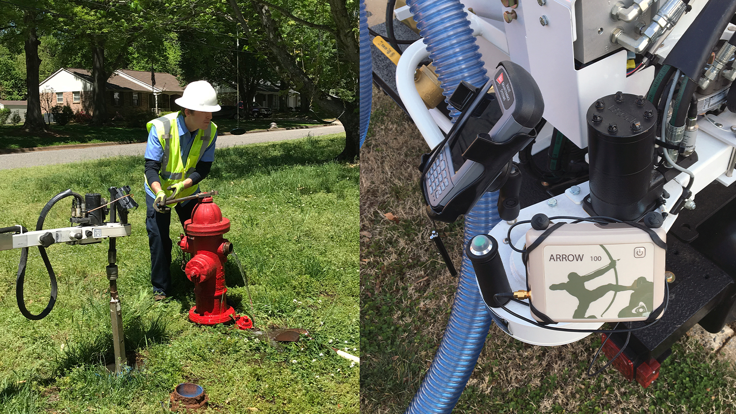
With Hart on board, the City of Gastonia purchased its first valve-exercising trailer, made by EH Wachs. The trailer came with a built-in handheld controller, which uses proprietary software to guide the exercising workflow.

“We brought in the right staff, with our two Brians [Hart and Potocki], and one made the case for a valve exerciser and trailer, while the other one was able to get the technical side of things running.”
— Ron Cook, Assistant Division Manager of Systems Maintenance, Two Rivers Utilities
“It does the whole process,” Hart said.
The controller is also capable of connecting via Bluetooth® to an external GPS receiver, which would allow TRU to update the location of its valves.
“Most of the locations were OK,” Hart said. “But they weren’t pinpoint accurate.”
The manufacturer recommended a specific brand of GPS receiver, but Hart wanted something that was more modern and easier to use. So Hart made the case for a new GPS receiver, and in 2017 he got his wish.
“We made him wait a year before he was allowed to change anything,” Cook joked.
The Solution: Arrow 100 for Valve Exercising
“We picked the Arrow 100 because it was easy to use and affordable.”
— Brian Hart, GIS Analyst, Two Rivers Utilities

Hart had read about the Arrow 100 GNSS receiver in an Esri Water Newsletter article featuring Le-Ax Water District in Ohio. He called Le-Ax and asked for recommendations.
“Le-Ax spoke highly of the Arrow 100 GNSS,” Hart said. “So we purchased our first Arrow 100 device.”
Hart worked with Eos Positioning Systems to make sure the Arrow 100 paired properly via Bluetooth® to the trailer’s handheld controller. Once paired, the Arrow 100 provided with an average of 40-cm location accuracy out of the box, using the free WAAS differential correction service.
“We picked the Arrow 100 because it was easy to use and affordable,” Hart said.
Its antenna was also small enough that Hart could have a welder mount it onto a trailer arm. The exact location of the valves could thus be recorded with the trailer arm extending over them.
The Workflow: Six Zones, Six Years, and Two Exercisers
“We’re always looking for the next best way to improve our efficiency.”
— Brian Hart, GIS Analyst, Two Rivers Utilities
Hart said it was easy to train two dedicated employees to start using the trailer and the GPS receiver.
“Everything has been straightforward,” Hart said. “Knock on wood, we haven’t had any hiccups on the tech side of things. And the exercising crew seem overall happy.”
The First Two Zones – Finding The Best Practice
To start, Hart divided the city into six zones, which he further divided into grids. Then, from ArcMap, he provided the field crew with paper maps of the grids with all the valve locations. They hired a field technician, who previously had worked for TRU and already knew the system well, to locate and spray-paint valves in the first two zones.
The exercising crew followed up with the trailer and exercised each valve. During the exercising, the crew was also able to update the valve locations. This is done thanks to the trailer controller’s Bluetooth® connection to the Arrow 100, which “snaps” the new coordinates to the valve’s ID. Afterward, Hart exported the controller’s data into ArcGIS Online for an updated view of the valve locations.
Sometimes, a valve not previously recorded in the GIS is found in the field. The crew would create a new record on the controller, and label it “NV” with a number, which stands for “New Valve Number X”. When Hart downloads the data, he can then identify all the new valves that need to be entered into the GIS. The naming convention also lets him keep track of the total number of valves discovered during the exercising program.
“In the South Gastonia zone alone,” Hart said, “we found 400 valves that were not in the GIS.”
So far, the South Gastonia zone is the first zone to have been completed. The second zone will be wrapped up soon.


The Third Zone – The Quest for Improvement
As part of an effort to increase efficiency, Hart wanted to pilot a second workflow for the third zone.
To do this, TRU purchased a second Arrow 100 GNSS receiver, which they then connected to an iPad® running Esri’s ArcGIS Collector®.
While the exercising crew was still working on the second zone, the field technician started on a third zone armed with both paper maps and the newly purchased Arrow 100 GNSS receiver. The field technician was then able to spray paint, as well as update the GPS coordinates of each valve.
In this way, the crew could save time by not having to locate the valves themselves, since they were already painted blue.
“We’re speeding up their time because they do not have to locate each valve themselves,” Hart said.
In addition, Hart didn’t have to do any manual data processing because Collector updated ArcGIS Online in real time.
“The field technician was almost too quick”, Hart joked. “Our guys would come later,” he added, “and some of the spray paint was already starting to wear away.”
The Fourth Zone and Beyond – Refining the Workflow
For the fourth zone, the team plans to pilot a third workflow. This time, they will send the field technician with the exercising crew to work together. The field technician will “leapfrog” just ahead of the crew, and paint each valve right before they get to it.
“We’re always looking for the next best way to improve our efficiency,” Hart said.
About the Results: Fewer Customer Service Interruptions, Modern Outlook

TRU anticipates immediate improvements on all fronts.
“We’ll be able to pinpoint valve shut-offs during a main break, as opposed to cutting off water to a larger section of customers,” Hart said.
Routine maintenance and scheduled repairs will also greatly benefit.
But the ultimate goal for Hart is a long-term movement to the Esri’s new ArcGIS Utility Network Management, which provides powerful valve-isolation tracing.
“Being able to isolate smaller sections of the water system — especially when we run valve-isolation traces during an emergency — will allow us to keep the service running for the other customers,” Hart said. “We are really passionate about customer satisfaction, and disrupting water service is a big deal.”
You May Also Like One of These Success Stories

5 Water Utilities Using Bluetooth GNSS Receivers
Five water utilities are using high-accuracy Bluetooth® GNSS receivers to transform their mobile data collection. Here’s how.

Alaska Utility Pinpoints Water and Wastewater Assets
Anchorage kicked off a 5-year GIS master plan with a GPS project using Arrow 100 for asset acquisition with Esri’s ArcGIS Collector and ArcGIS Enterprise.
