Raptor Aerial Services in Texas provided a brand-new updated orthophoto mosaic, digital elevation model, and 3D topographic map of Enchanted Rock State Natural Area to be used for education, planning, search and rescue, field research and more
About the Location: Enchanted Rock State Natural Area
Enchanted Rock State Natural Area is an adventurer’s dream. The recreational site is known for its flagship granite dome, which stretches hundreds of feet up and draws countless free-hand climbers each year to conquer its pink granite face.
The park is home to researchers, too. The University of Houston hosts an annual field camp for geophysics students each May. The students make the four-hour drive east of Houston to perform a variety of field experiments and measurements. To position their work in the field, students rely on older topographic maps and also on Google Earth.

In 2018, the University of Houston partnered with Texas Parks and Wildlife Department to perform an aerial survey of the park. The objective was to create a brand-new orthophoto mosaic, 3D topographic map and digital elevation model of Enchanted Rock State Natural Area. The students could use the new orthophoto for their research and educational field mapping exercises, and the park could use it for their operations and planning. Tasked with everything from performing search and rescue and onboarding new park rangers to identifying new trails that have formed over time and after ad-hoc hikes, the parks and wildlife team could use updated data.
Raptor Aerial Services was brought in for the job.
About Raptor Aerial Services: Texas Consultancy
“I can fly a drone survey every quarter for approximately the same price my customers would have had to pay for a single survey using traditional methods.”
— Michael Allison, Raptor Aerial Services
Raptor Aerial Services is a private drone services provider. The Texas-based consultancy provides aerial services ranging from drone photography and surveying to downstream stockpile analysis and inspections. Owner and founder Michael “Mike” Allison, who has a background in oil, gas, and the information technology (IT) industries, transitioned into drone GIS services after realizing the growing potential value of drone technology.

Allison’s customers range from counties that require flood analysis (business boomed after Hurricane Harvey hit Houston in 2017), to mining companies that would like to transition from traditional surveying to more agile drone surveying.
“I can fly a drone survey every quarter, and do the volumetrics calculations, for approximately the same price my customers would have had to pay for a single survey using traditional methods,” Allison said. “Besides that, I provide them with documentation that they’ve never had before.”
Allison’s company is part of a growing trend for companies — especially those managing large land parcels like mining companies, state parks, and oil and gas companies — to take advantage of drone surveying.
Allison also serves his former industry, oil and gas. He uses specialized sensors, like a magnetometer, on a drone to locate old wellheads. Buried under the ground, these abandoned wellheads are not exposed, but authorities want to make sure they were properly plugged. “So an aero-mag survey can record the magnetic field,” Allison says. “Drones are great for flying these kinds of surveys. They used to be done frequently by airplanes and helicopters.”
")
About the Solution: Surveying a Rock with “a Lot of Topography”
“When you go to the field and you’re in the middle of nowhere, you might not have access to a truck with a power inverter.”
— Michael Allison, Raptor Aerial Services
At 750 acres, the Enchanted Rock survey area constitutes “a lot of topography.”
While most projects at Raptor Aerial Services can be done in less than a half day, Allison budgeted two days for Enchanted Rock.
“It’s a fairly complex survey,” Allison said. To get started, he needed to select the right tools for the trade.
“I’m just using the tools that work for me,” he says. “I want to be as efficient as possible. So if I can find a solution, and I can understand it, and if it makes my life easier, that’s what I’ll use.”
")
Selecting the Drones: The DJI Inspire 2
Allison brought one primary drone to the field: the DJI Inspire 2.
Equipped with a 20 megapixel HD camera, the DJI Inspire 2 gets used most often at Raptor Aerial Services for drone aerial surveying and mapping.
Allison recommends anyone performing drone work invest in backup equipment. To this survey, he brought an extra drone, extra iPad®s, and about 30 batteries and Pelican cases. The batteries maximize productivity by eliminating the inevitable need to recharge batteries, and the cases protect them.
“When you go to the field and you’re in the middle of nowhere, you might not have access to a truck with a power inverter,” he says.
The drone utilizes two batteries per flight, which means 20 batteries yields 10 flights. Each flight lasts about a 25 minutes, so one drone with 20 batteries can fly about four hours per day.
Selecting the GNSS (GPS) Receiver: Arrow Gold for Ground Control Points
“The thing I enjoy about the Arrow Gold is that it’s very rugged, because I’m out in the field a lot. It’s easy to put together, easy to hook up, and easy to understand. And it works really well. I’m using the Arrow Gold just like the surveyors would.”
— Michael Allison, Owner, Raptor Aerial Services
To georeference the drone imagery, Allison sets up ground control points, or GCPs. GCPs are “known points,” or locations where latitude, longitude and elevation are precisely surveyed. The GCPs stick out in the drone imagery with their bright orange colors or other visible patterns depending on the type of marker used. Having anywhere from five to seven, up to a couple dozen, GCPs (depending on the parcel size) allows software to rectify the drone’s imagery and stitch them together with extreme accuracy.
“I’m a stickler on accuracy,” Allison said. “I want to make sure the work that I’m doing for a client is very good.”
To set up his GCPs, Allison chose the Arrow Gold GNSS receiver. Allison chose the Arrow Gold because it offers centimeter accuracy, is rugged, and was easy to use.

“The thing I enjoy about the Arrow Gold is that it’s very rugged, because I’m out in the field a lot,” he says. “It’s easy to put together, easy to hook up, and easy to understand. And it works really well. I’m using the Arrow Gold just like the surveyors would.”
Allison has created his own “GCP kit” with the Arrow Gold. He uses a three-foot circular target from Hoodman that is both durable and can easily fold into a pouch. When it’s unfolded, each GCP kit is secured and weighted down by a rigid steel structure. The GCP stays low to the ground and has a plus sign painted on it, along with a stenciled number, to identify it.
Allison said it’s incredibly easy to see the GCPs from 400 feet in the air.
“People love them,” he says.
When Allison knows he is going to be flying in an area with a lot of topographic relief, he also uses a handful of alternative GCPs. These ones are larger at four feet by feet feet and colored with black and white vinyl, to create a clearly visible center. They’re a little bit bigger and easier to see from higher altitudes, but they require being anchored down with weight on the corners to avoid blowing away.
Selecting the Software: Global Mapper, GPS Tracks, DroneDeploy and Correlator3D
To plan and process the drone imagery, Allison usually uses a variety of applications.
The first is Global Mapper. With desktop and mobile versions, Global Mapper bills itself as “an affordable and easy-to-use GIS application”. Allison uses it to model his flights, including how his GCPs and launchpads are laid out and how the survey is actually shot. As a small business owner, he was looking for just a basic map-making tool.
“For me, it’s perfect. It’s very affordable and easy to learn.”
Global Mapper offers add-ons, such as a LiDAR module, but Allison says he sticks to the basic desktop version for most projects. It costs $550 per license (at the time of this writing).
Allison also uses a combination of Google Earth and GPS Tracks, an iOS® and Mac OS app that helps him plan GCPs. After planning GCPs in Google Earth, he saves the KML files and imports them into GPS Tracks on an iPhone® X, which he uses to position the GCPs in the field.
“So when I’m out in the field, trying to position GCPs, I already know exactly where I’m going to put them,” he says. “It just makes the planning and the actual work so much easier once you’re there.”
Allison also uses SimActive’s Correlator3D for post-flight processing. Although Allison admits there are a number of excellent products that can do what Correlator3D does, he says, “I really like Correlator3D. It’s fast, visually oriented, easy to understand, and the support is very good.”

Enchanted_Rock_Drone_Survey_Area-4")
Step One: Laying GCPs
“Since I pre-planned all the GCPs, the GPS Tracks app tells me where to go to lay them. If you do a good job with the GCPs, then they are pretty easy to find in the imagery.”
— Michael Allison, Raptor Aerial Services

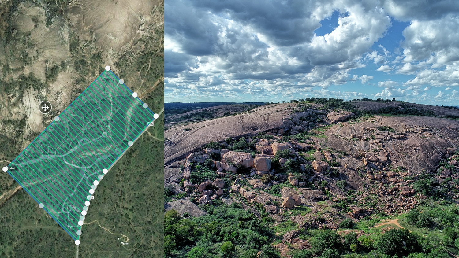
There are two main peaks in Enchanted Rock State Natural Area (including the one for which it is named). So Allison divided the park into four sections. Two of these were at lower elevations, and the other two included the peaks. He flew the lower elevation sections the first day.
On a Monday morning, park rangers drove Allison to his planned GCP locations in a utility task vehicle, or UTV, to lay his ground control points. They navigated to each point based on locations Allison had downloaded to his iPhone and placed each GCP. He positioned about 20 GCPs in total.
“Since I pre-planned all the GCPs, the GPS Tracks app tells me where to go to lay them,” he says. “If you do a good job with the GCPs, then they are pretty easy to find in the imagery.”

Next, Allison drives to each GCP and surveys its center with the Arrow Gold. For this project, he connected to an RTK Network in Texas.
To record each location, Allison takes a screenshot of Eos Tools Pro. Since Allison only lays about 10-20 GCPs per flight, he prefers using screenshots instead of launching a separate app or recording locations by hand in the field.
“It’s a pretty efficient process,” he says.”I just hook up to iPad, make sure the software is up to date, and I know I’m going to get a good location because the product works so well.”

GCP Photo Gallery:


Step Two: Taking Flight according to the Plan

With the GCPs laid and logged, Allison returns to grab his drones, drives out to his planned launch site, places his launchpad, and starts the drone. Each section of Enchanted Rock took about two to three hours to fly, during which time Allison made sure to keep the half-mile line of sight required by the FAA. He also swapped out the batteries as required.
“I don’t like to fly the drone for more than half a mile from the launchpad,” he says. “You can increase the risk of a remote controller losing communication, or something else happening where the drone lands unexpectedly.”
After two days of flying Enchanted Rock, Allison took his data back to the office to create the brand-new orthophoto mosaic of the state natural area.
Step Three: Stitching Images with the “Rubber Band” Effect
Allison uploads a file of the GCPs to the drone processing software.
In the past, he’s manually calculated the orthometric height from the GCPs’ ellipsoidal height, but after Eos’ release of Geoid12B models support, he now captures orthometric heights in the field via his screenshots of Eos Tools Pro.
He tags the GCPs in the images in the software. By tagging the center, he ensures accuracy.
“Essentially what you’re doing is you’re helping the software determine where the GCP is,” he says. “The result is you get a very accurate georeferenced orthophoto.”

The Results: Providing a Brand-New 3D Topographic Map and Digital Elevation Model
“Now they have digital elevation models and 3D georeferenced tiff files and shapefiles. You can do an awful lot with this data.”
— Michael Allison, Raptor Aerial Services

Raptor Aerial Services delivered the park rangers and researchers the complete, survey-grade photo mosaic. They also delivered a digital surface-elevation map with three contour levels (5 foot, 10 foot and 20 foot).
“The great thing is, the weather was beautiful, and they had just had a lot of rain,” Allison says. “So the vegetation was green, and the imagery came out quite nice.”
Allison says that now the data is georeferenced, “gosh, you could do anything.”
The park has mentioned using the maps for a variety of purposes, including educational uses. In addition, park rangers can compare the updated orthophoto mosaic to the older maps they were using to see if anything has visibly changed with the rock formation or if new trails have been formed. They may also use the data to onboard new park rangers and perform search and rescue.
The University of Houston geophysics department will access their data during their annual field camp.
“You can do an awful lot with this data,” Allison says. “Now they have digital elevation models and 3D georeferenced tiff files and shapefiles. It’s higher resolution than what they can get on Google Earth.”


Download a PDF of this article in ENGLISH.
