Using Location-Based Technology to Protect Sea Turtles so that They Can Hatch and Go Home to the Ocean
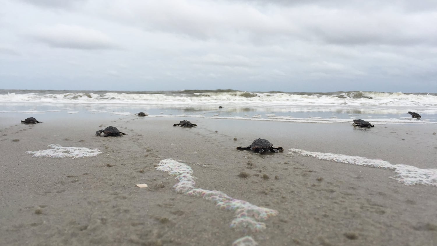
Even before they bust through their shells and head for the ocean en masse, sea turtle hatchlings face many dangers during their two-month incubation period on shore. High-tide surge, produced by hurricanes, can wash away nests or inundate them with water. Hatchlings, instinctually attracted to moonlit waters, can become confused and lost when beachfront homeowners or occupants keep their lights on past 10:00 p.m. Although this violates a local municipal lighting ordinance, it still happens.
Hatchlings that go toward any artificial light may think they are following the moonlight, which would have guided them to open water. Instead, they do not arrive at the ocean and meet a tragic end.
For example, during the 2020 nesting season, 23,749 baby loggerhead turtles from 291 nests hatched on Hilton Head Island beach in South Carolina, according to Sea Turtle Patrol Hilton Head Island (Sea Turtle Patrol HHI), a volunteer-based program launched in 1985. But an estimated 13 percent of them died due to beachfront-lighting violations.
“It is a very small request to ask beachfront residents to turn their lights off after a certain late hour,” said Amber Kuehn, director of Sea Turtle Patrol HHI. “The flip of a switch or the turning down of window shades can save an endangered species.”

Watch The Today Show‘s video interview with Sea Turtle Patrol Hilton Head Island, featuring the Arrow 100® GNSS receiver:
In addition, Hilton Head Island is a major tourist destination, so another threat to the nesting sites is beachgoers themselves. People wandering around the beach in the wee hours, shining flashlights as they look for baby turtles, can have the same effect as the beach-house lights.
To keep as many turtle eggs and hatchlings safe as possible, a small team of volunteers from Sea Turtle Patrol HHI combs Hilton Head Island beaches from May through October—turtle nesting season—marking loggerhead turtle nests with poles and tape and then monitoring and inventorying those nests.
Sea Turtle Patrol HHI, which receives a permit from the South Carolina Department of Natural Resources (SCDNR) to do this work, trains the volunteers on how to mark the turtle nests; carefully watch for hatching activity; and collect data about the eggs, nests, and hatchlings according to guidelines set by the state. To do these tasks, Sea Turtle Patrol HHI members use an Arrow 100 submeter Global Navigation Satellite System (GNSS) receiver from Eos Positioning Systems and the Esri ArcGIS Collector app for iOS®.
The patrol members mark the location of the egg nests in ArcGIS Collector running on an Apple iPad® paired via Bluetooth to an Arrow 100 submeter GNSS receiver. While the iPad’s integrated GPS accuracy ranges from about 0-15 meters (depending on conditions), the Arrow 100 improves this accuracy down to a reliable submeter level. The Arrow 100 can do this by using free real-time differential corrections from the Wide Area Augmentation System (WAAS). WAAS is a Federal Aviation Administration-operated (FAA) public source of submeter GPS corrections via satellite. After calculating the position of each nest, the Arrow 100 transfers these high-accuracy latitude and longitude values and GNSS metadata via Bluetooth into ArcGIS Collector on the iPad. A map is produced of the nests’ locations using ArcGIS Collector.

By identifying new nests on a daily basis, the patrol volunteers have an opportunity to increase the hatchlings’ survival rate. Within the first 12 hours of a nest being laid, Sea Turtle Patrol HHI can relocate nests away from the precarious tidal margin, where they are subject to flooding by tidal waves. Patrol members also can use poles to help alert beachgoers to the nest locations, preventing them from disturbing the eggs.
An average of 325 nests are laid per season on Hilton Head Island beaches, though as many as 463 nests have been laid in one season. The egg chamber, which is the area of the nest that contains the eggs, is approximately 6 inches in diameter at the top, graduating to 12 inches at the bottom, and 2–3 feet deep. An average of 120 eggs are laid per chamber, and the average incubation period is about 60 days.
To mark each nest, patrol volunteers position the nest chamber in the center of a triangle created by poles. The poles serve a dual purpose: making the nests easily observable for tourists and other beachgoers and being visually distinct so that the patrol team can easily monitor the nest for hatching.
By having the exact location of the nests mapped, Sea Turtle Patrol HHI can find nests even if storms or beachgoers disrupt the marker poles and flagging tape. The digital map also gives Sea Turtle Patrol HHI an excellent overview of the nesting sites, including the total number of nests and their locations.
If an issue arises on the beach, patrol members can identify any potentially affected nest by viewing the map on their mobile device. Moreover, if a resident reports activity at a nest, the team can easily associate the report with specific nests based on a descriptive location and the proximity of the beach markers, which are located every tenth of a mile and also marked with GPS coordinates.
“This ability to have a full view of each nest and [its] proximities to important [markers] is invaluable, especially when considering that the response area is 14 miles of beach and that this area is also a highly trafficked tourist destination,” Kuehn said.

Banding Together to Save Sea Turtles
All species of sea turtles are federally protected under the Endangered Species Act. Because of this federal protection, state governments have been granted the authority to monitor sea turtles’ nesting beaches on coastlines in the United States. The goal is to find ways to give the hatchlings a higher survivability rate and document nesting density and success. Hilton Head Island is one popular nesting coastline, especially for loggerhead turtles, which nest there 95 percent of the time. Hilton Head Island also sees small numbers of green sea turtles and leatherbacks. One Kemp’s ridley sea turtle has nested there too—an extremely rare event. The turtle does not return each year, and it was only the fourth such turtle to nest in South Carolina.

Encouraged by the federal protection granted by the act, the SCDNR initiated volunteer-based programs, including Sea Turtle Patrol HHI. Sea Turtle Patrol HHI is run by Kuehn, a permit holder who was selected by an application process. The permit holder is responsible for managing and training volunteers to mark loggerhead turtle nests, monitor nests for hatching activity, and inventory the results according to guidelines set forth by the state. The permit holder for each beach in South Carolina is also responsible for inputting data into the SEATURTLE.ORG website. All of the work done by Sea Turtle Patrol HHI is funded by private donations, such as those from the local community, along with grants from nearby businesses.
Sixteen volunteers, ranging from 20 to 78 years old, currently serve on Sea Turtle Patrol HHI. Each day during the nesting season, they monitor 17 miles of local coastline that are known sea turtle nesting sites. The daily patrol area consists of 14 miles of main, ocean-facing beach along with 3 miles that include two side beaches on Port Royal Sound, on the north end of the island. The first patrol rolls out May 1 at 5:00 a.m., and each day, the patrol lasts until the volunteers have marked all nests laid the night before. To spot the nests, they look for female loggerhead turtle tracks. On any given day, there could be up to 10 volunteers on these beaches at one time. Some use a John Deere Gator utility vehicle or a jeep, and some patrol on foot, depending on the stretch of beach.

On Hilton Head Island, about 113 sea turtles lay an average of four to six nests per season in two-week intervals. This means that when patrol members finally detect no new nests for a full two-week period, they can officially conclude that the nesting season has ended.
Before adopting the new system of marking and mapping nests, reaching a successful conclusion to the end of nesting season was dicey. What kinds of hurdles can the turtles face?

First, in South Carolina, hurricane season officially begins June 1 and ends November 30, with the peak period for these storms from mid-August to mid-October. This is the same time frame as sea turtle hatching season.
Second, Sea Turtle Patrol HHI had always used GPS to mark sea turtle nests, but the accuracy was generally six feet off the mark. This became an issue after Hurricane Matthew struck Hilton Head Island in 2016, but it became an even more serious issue when storm surge from Hurricane Irma affected the island the following year. Without highly accurate satellite-based technology, it was difficult to find nests that had lost physical markers during storms.
When Hurricane Matthew struck Hilton Head Island on October 8, 2016, there were only two nests left on the beach, as the end of the hatching season was near. Both nests were lost due to the storm. On September 11, 2017, Tropical Storm Irma left significant flooding in its path while the island was still recovering from Hurricane Matthew. Irma occurred earlier in the season than Matthew, and there were 54 sea turtle nests still incubating on the beach. Irma’s waves washed away all of the remaining nest marker poles, and Sea Turtle Patrol HHI had hoped to find those 54 nests to determine their status. However, a GPS that could only bring the user to within six feet of a six-inch hole was not very helpful. Only eight nests were found. Without the nest locations precisely mapped, it was difficult to find the egg chamber. Sea Turtle Patrol HHI needed better technology to locate and map nests in order to save them in the event of natural disasters such as hurricanes and tropical storms.
Enter Higher-Accuracy Mapping for Marking and Monitoring Nest Locations
The technology that Sea Turtle Patrol HHI needed was already being used by the Town of Hilton Head. The municipality had worked with the mapping experts at Anatum GeoMobile Solutions to implement a mapping workflow that documented facility status and storm damage using an Arrow 100 submeter GNSS receiver from Eos Positioning Systems and the ArcGIS Collector app on iOS.
The town had the ArcGIS Collector app set up for mapping, so the municipality provided Sea Turtle Patrol HHI with access to an appropriate map in ArcGIS Collector. Money was raised to purchase an Eos Arrow 100 GNSS receiver to mark sea turtle nests.

During the 2019 sea turtle nesting season, each of the 463 nests laid were documented using the new Arrow 100 GNSS receiver. After identifying a potential nest, patrol volunteers probe for soft sand to find the area where a mother turtle has dug the two-foot-deep nest cavity, dropped her eggs, and covered them up with about a foot of sand. She disguises the nest to make it difficult for predators to find. But once the egg chamber’s exact location is found, the Arrow 100—attached to a survey pole—is gently placed over the center of the nest to capture latitude-longitude coordinates via Bluetooth connection to ArcGIS Collector running on an iPad.
With the Arrow GNSS receiver, Sea Turtle Patrol HHI volunteers can calculate a location within six inches of the mark—much better than the six feet of the past. Then, three poles are inserted in a triangular formation with a one-foot margin around the nest to mark the area. The nest is captured as a point with a unique numeric identifier.
Sometimes, the patrol moves the eggs closer to the dune. In this case, the original location and the new location are recorded for historical data. Exact egg counts are taken, and after around 60 days of incubation, the nest hatches.
Three days later, the patrol returns to inventory the nest. At inventory, the volunteers dig up the contents of the nest to determine how many sea turtles hatched. They count those that did not hatch and release any hatchlings that may have gotten stuck inside the chamber.
Keeping track of these nests with the new system was highly successful in 2019 and again in 2020 and 2021. ArcGIS Collector generated a map with visual marks and amazing accuracy based on the latitude-longitude coordinates from the Arrow 100 GNSS device.

Dealing with Everything from Lighting Violations to Climate Change
There hasn’t been a hurricane to contend with since Sea Turtle Patrol HHI acquired the Arrow 100 submeter GNSS receiver and ArcGIS Collector. However, sometimes tourists remove nest-marker poles, either to use as bottle rocket launching devices, to move them out of the way, or just to be mischievous. In any case, the positional accuracy of the nests mapped with the Arrow 100 GNSS receiver allowed the patrol to easily pinpoint the egg chamber and replace the poles.
From now on, the patrol will always be able to find the hatchlings with the Arrow 100 receiver and ArcGIS Collector, no matter what challenge nature or humans present.

“Sometimes, people are determined to see hatchlings escaping in the night, and their use of flashlights results in a devastating outcome,” Kuehn said.
Using the new mapping solution, for instance, patrol members can easily enter beachfront lighting violations into ArcGIS Collector. If a lighting violation occurs in the vicinity of a nest, the patrol notifies the Town of Hilton Head code enforcement division, which delivers a warning to the address.
With climate change and sea level rise, Sea Turtle Patrol HHI members have noticed extremely high tides in the last couple of years. This past season, volunteers waited for the king tide and used the GNSS receiver to measure the highest water level along the beach. Patrol volunteers took water-level measurements using the GNSS device every tenth of a mile on the 14 miles of main beach.
“ArcGIS Collector uses the marks to indicate a line on the map, which gives us our bearings in a very easy, visual capacity,” Kuehn said. “This information will help us predict where the water will reach in future nesting seasons with greater accuracy, and we will be able to move our nests above that mark.”
With the new mapping technology and an army of passionate volunteers banding together with both local benefactors and municipal teams, the Sea Turtle Patrol HHI director is hopeful.
“It takes an army of volunteers to preserve this endangered reptile,” Kuehn said. “Anything to make it easier is greatly appreciated.”
To learn more about Sea Turtle Patrol HHI and support its mission, visit the Sea Turtle Patrol HHI website.
This story was originally published in Esri ArcWatch. View the original article here.
You May Also Like One of These Posts

3 ways handheld GPS receivers support biodiversity
In celebration of this international biodiversity day, we’re highlighting how Arrow handheld GPS receivers are being used to save species worldwide!

Customer Spotlight: Brian Tucker Uses GIS to Conserve Native Hawaiian Tree Species
Using an Arrow 100 GNSS receiver and Esri’s ArcGIS, Brian Tucker helps protect Hawaii’s most abundant native tree from a fungal pathogen.
