The Customer: Rockett Special Utility District

Just outside Dallas, Texas, Rockett Special Utility District (SUD) serves about 12,000 customers and manages 570 miles of distribution lines. Rockett SUD’s service area includes rural subdivisions and extremely rural areas, where valves can be spread apart by miles, and meters are not always located right in front of a house. Locating assets in the field can be challenging, and as urban sprawl increases service demand, Rockett SUD wanted to streamline its efficiency in the field.
The Challenge

The utility’s existing CAD drawings were not accurate enough to easily locate water meters, valves, hydrants, and flush hydrants in the field. Crews would frequently call utility staff multiple times per day to ask where they remembered the asset being and to try to get verbal guidance.
“Without having reliable GIS and GPS records distributed organization-wide, we had to go on memory for where we remembered an asset being,” said Benjamin Rucks, Rockett SUD geographic information system (GIS) crew lead. “In the very rural areas, although we have the paper maps, it takes your eyes seeing a water meter and sometimes a good memory to remember where it was.”
At one point, the utility purchased a consumer-grade GPS data collection receiver, but when the device’s memory was full, its information was downloaded onto a computer, where it stayed. This data was rarely used nor was it widely shared.
Rockett SUD wanted a highly accurate and widely available map of its assets to better prepare for the future. The utility requested the input of GIS consultants Texian Geospatial and Asset Solutions.
“When we went into the field to try to locate the assets, it was obvious that the CAD maps were far off,” said Benjamin Griffith, Texian Geospatial GIS project manager. “This is expected, because CAD isn’t always tied to a geographic location.”
The Solution


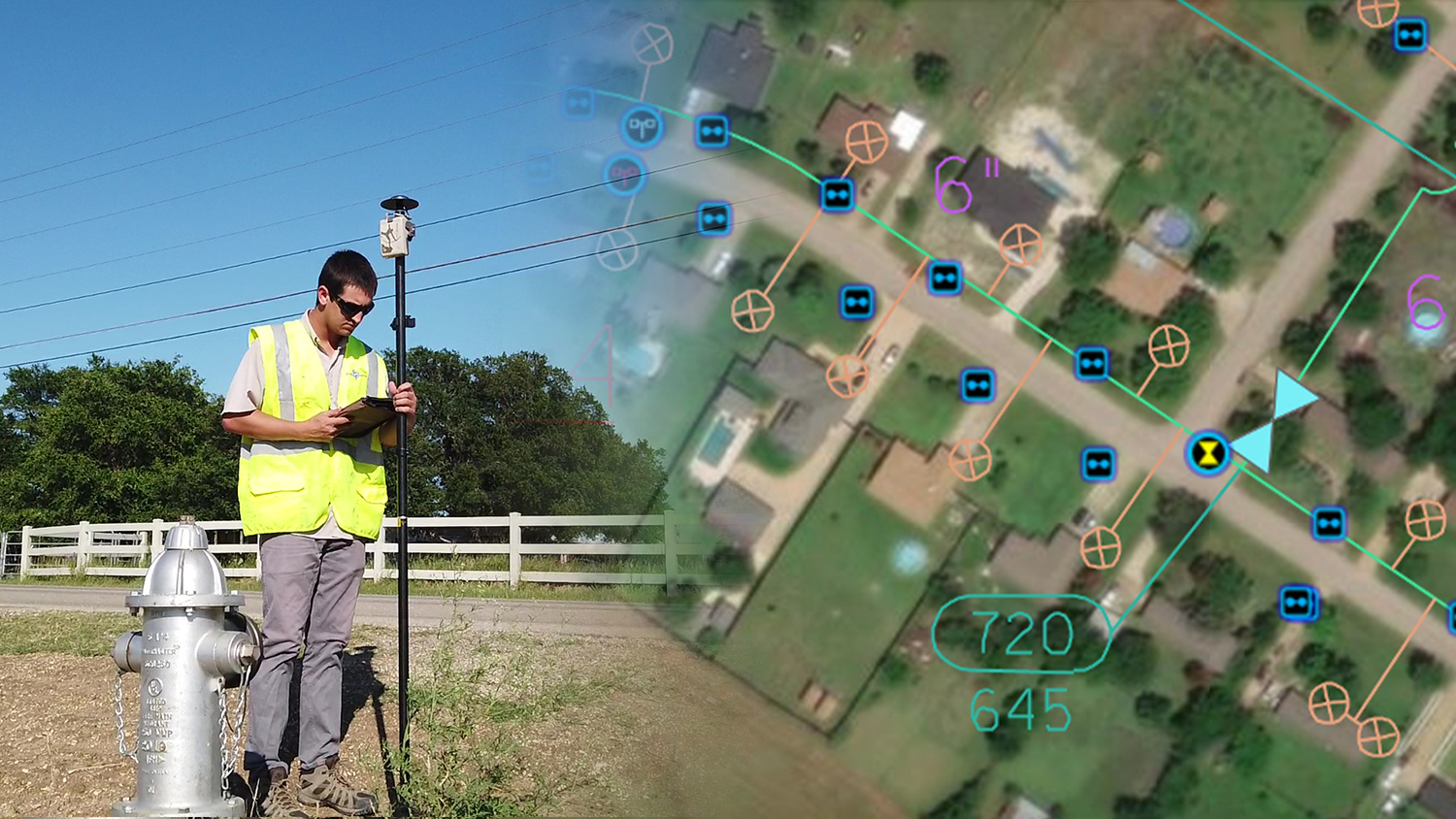
To help Rockett SUD create a system of record in these extremely rural areas, Texian Geospatial proposed the implementation of a modern, real-time, field-to-office mapping system compatible with the Esri platform. This new digital mapping system would replace the utility’s paper-map workflow while drastically reducing — or even eliminating — the field workers’ reliance on knowledge holders’ memories of asset locations.
First, Texian Geospatial set up an ArcGIS Online organizational account. This allowed Rockett SUD to share and update web maps in real time between the field and the office. These web maps were configured using the Water Distribution System Foundation template, a free solution to Esri customers that provides preconfigured layers for water utilities. By using this template, Texian Geospatial also ensured Rockett SUD’s data would match Esri’s ArcGIS Utility Network user type extension scheme, which the utility is interested in using in a subsequent phase.
For real-time data collection, Texian Geospatial helped Rockett SUD deploy ArcGIS Field Maps (formerly ArcGIS Collector). ArcGIS Field Maps features drop-down attribute selection for fields that directly correspond to the ArcGIS Online template, along with the capability of working in an offline mode in spotty cellular coverage areas.
“The Esri software suite was new to me,” Rucks said. “It took some trial and error, but once we understood how everything worked together, Field Maps became pretty easy to use.”
Field Maps also supported Global Navigation Satellite System (GNSS) metadata and accuracy thresholds from high-accuracy Bluetooth® GNSS receivers. Because the utility wanted reliable survey-grade GPS locations, Texian Geospatial deployed an Arrow Gold® GNSS RTK base station and two Arrow Gold® rovers. The Arrow Gold® base station, installed at Rockett SUD headquarters, uses satellite and internet to broadcast real-time differential corrections to the Arrow Gold® rovers in the field, providing centimeter-level accuracy both horizontally and vertically.
“We set this up with an Arrow Gold® RTK base station at Rockett headquarters to provide survey-grade accuracy throughout the service area,” Griffith said. “Because the utility expects to collect data for many years, it was more cost-effective than purchasing differential correction subscriptions from a private RTK network provider.”
The Arrow Gold® GNSS receivers were paired to iPad®s outfitted with a special cooling case to help prevent overheating in the hot climate of Texas. ATVs were used to navigate to addresses listed in the meter route books. They proved to be extremely convenient for the crew to get around other vehicles on back roads, allowed them to park almost anywhere, and also kept the GNSS receiver locked on to satellite signals while driving between addresses.
The Results

In just seven months, two field workers collected over 4,000 water meters, valves, hydrants, and flush hydrants. With a fully mapped system, field workers no longer have to call in and constantly inquire on the location of assets, thus saving time both in the field and at the office.
“Now everyone can see where the assets are located, accurately, thanks to ArcGIS Online and the Arrow Gold®,” Rucks said. “It frees up our water system experts to do their own work, because they no longer have to answer calls to help people locate assets. Everyone has access to the same information.”
Rucks expects additional savings from faster response to water main breaks. “They can easily locate the asset with their phone or tablet and start the repair, instead of having to make several phone calls,” he said. “Our customers will be served more efficiently.”
The new mapping system has also allowed the crew to record valves and meters that weren’t included in the paper maps. “I’m sure somebody knew where they were at some point, but those people are no longer employed here. Thankfully, from now on, the maps and the knowledge they contain will stay forever,” Rucks said.
Download a PDF of this article in ENGLISH.
You May Also Like One of These Success Stories

5 Water Utilities Using Bluetooth GNSS Receivers
Five water utilities are using high-accuracy Bluetooth® GNSS receivers to transform their mobile data collection. Here’s how.

Haiti Outreach Improves Potable Water Access with Atlas
Haiti Outreach involves locals in its water mission. They use mWater to prioritize work and Arrow Gold with Atlas to model distribution systems in EPANET.
