Eos Positioning Systems

Tel.: +1 (450) 824-3325 (CAN)
  • Technical Support
  • EnglishEnglish
    • Français Français
    • Español Español
  • Home
    • About
    • Contact
    • Technical Support
    • Subscribe
    • Testimonials
    • Users
  • Products
    • Arrow Series™
      • Arrow Gold
      • Arrow 200
      • Arrow 100
      • Arrow Lite
      • Comparison Chart
    • Accessories
      • Antennas
      • Mounting Equipment
      • Extra Battery & Power
      • Field Gear
      • Atlas® Service
    • Tools and Apps
      • Eos Tools Pro
      • Eos GNSS Tools
      • Eos Utility
      • Eos Server
      • Arrow USB Drivers
    • Solutions
      • Geoid Height
      • Eos Locate™ for ArcGIS
      • Laser Mapping
  • News
    • Latest News
    • Success Stories
    • Events
    • Newsletter
    • Press Releases
    • Blog
  • Learning Center
    • Arrow
      • How-To Articles and PDFs
      • Video Tutorials
      • Arrow Datasheets (PDFs)
      • Manuals (PDFs)
    • GNSS
      • GNSS Articles
      • iOS and Bluetooth®
  • Partners
    • Field Apps
      • Esri
      • AmigoCloud
      • CartoPac®
      • Corvallis Microtechnology (CMT)
      • DigiTerra
      • Futura
      • GeoMobile Innovations
      • GI Geoinformatik GmbH
      • mapitGIS
      • SPOT
      • SST Software
      • TAXUS IT
      • TerraGo
    • Hardware
      • iOS
      • Android
      • Windows
      • Laser Technology
      • Tablet EX Gear
CONTACT
  • Home
  • News
  • Latest News
  • How to Configure Initial Settings in Collector and Eos Tools Pro

How to Configure Initial Settings in Collector and Eos Tools Pro

by Eos Positioning Systems / Tuesday, 07 July 2020 / Published in Latest News, News, Video Tutorials
Feature Image 2 - How to Configure Initial Settings in Collector and Eos Tools Pro_

Synopsis

Eos Locate™ is a solution based within Eos Tools Pro that allows a field worker to collect georeferenced data of underground assets by using Esri’s ArcGIS Collector. The data collected includes all parameters from a locator device (such as depth below cover and frequency) along with high-accuracy GNSS locations and metadata from your Arrow receiver.  This video series will walk you through the steps required to perform your locate workflow. In this video, we will show you how to configure some initial settings in Collector and Eos Tools Pro.

Welcome to Eos Locate™ for ArcGIS Collector. This video series will walk you through the steps required to perform your locate workflow. In this video, we will show you how to configure some initial settings in Collector and Eos Tools Pro.

Before we begin, ensure that your Arrow receiver is ON and connected via Bluetooth® to your iOS device for Eos Tools Pro. Please note that the Eos Locate menu is not displayed in Eos Tools Pro, and is only activated by Collector upon a locate request.

First, open up ArcGIS Collector. Navigate to the Settings menu, and then select Location Provider. Here, you will want to add your Arrow GNSS receiver. Click Add and select your Bluetooth®-paired Arrow receiver. Then, tap Done. Now, select it as your Location Provider.

Please note that in Collector’s Location Profile, you will also need to configure the required datum transformation. This will not be covered in this tutorial. Please refer to your GIS professional if you are not familiar with these Collector settings.

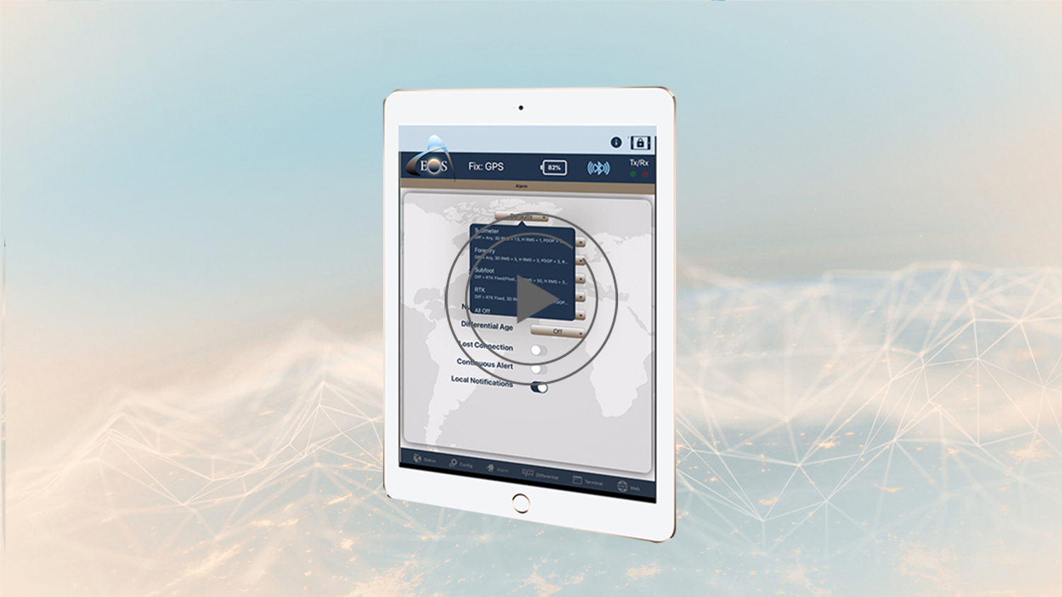
Now, go back to Eos Tools Pro. When acquiring a GNSS location in Eos Locate™, you can make sure of the quality of the position by setting threshold values in Eos Tools Pro. There will be audible alarms for GNSS conditions in Eos Locate™ and for Eos Tools Pro, and certain parameters (such as estimated accuracy, differential status, and age of differential correction) that will be displayed in red color when their threshold values are exceeded.

As you can see, we have purposefully placed the antennae in a location with poor visibility to trigger the alarm.

In order to set the GNSS alarms, open Eos Tools Pro, and tap on the “Alarm” tab at the bottom of the main menu. In the Alarm menu, set the alarms required for your accuracy. If you want centimeter accuracy and are connected to an RTK network, select RTK. You also can select Submeter depending on your accuracy needs.

Now, back under the Position tab, you can see all the field data that is outside the alarm thresholds.

If precise elevation is required for your workflow, we strongly suggest taking a moment to configure real-time orthometric heights to match your vertical datum. In this section, we will show you how to configure Eos Tools Pro so that it outputs orthometric height measurements in the Z-value of the point geometry in Collector. This is possible thanks to built-in geoid models within Eos Tools Pro.

To do this, tap the Config tab at the bottom of the main menu. Select Altitude in the upper menu bar. Now, from the Altitude Reference drop-down, select Orthometric. You will be presented with a list of supported (downloadable) geoid models. Scroll down to your country and select the geoid model you wish to download.

For fieldwork in the USA, you will want to select GEOID 18/NAVD88 (NAD83 2011).

The geoid model will download to your device. Once downloaded, select the model by simply tapping on it (a selection checkmark will appear to the right). Then, tap Done.

Back in your Eos Tools Pro position tab, you will now see your orthometric height.

Congratulations! You’ve now configured Eos Tools Pro. You will find a complete manual on how to setup Eos Locate with your kit. If you have any additional questions, please contact technical support on the Eos website.

If you have any additional questions, please contact Eos technical support.

Watch video 1: How to set up ArcGIS Pro with the Eos Locate™ Toolbox
Watch video 3: How to pair your vLoc Locator to iOS via Bluetooth®
Watch video 4: How to configure settings for Eos Locate™ and ArcGIS Collector
Watch video 5: How to Collect Underground Assets with Eos Locate

Browse more Eos videos:

Feature Image - Best Practices for Evaluating Field GIS Technology for the Modern Professional
20/11/2020
Best Practices for Evaluating Field GIS Technology for the Modern Professional (2020 MiCAMP Presentation)
READ MORE
Feature Image 4 - How to configure settings for Eos Locate and ArcGIS Collector
09/07/2020
How to configure settings for Eos Locate™ and ArcGIS Collector
READ MORE
Feature Image 3 - How to pair your vLoc Locator to iOS via Bluetooth
08/07/2020
How to pair your vLoc Locator to iOS via Bluetooth®
READ MORE
Feature Image 1 - How to set up ArcGIS Pro with the Eos Locate™ Toolbox
03/07/2020
How to set up ArcGIS Pro with the Eos Locate™ Toolbox
READ MORE
Eos Laser Mapping: How to configure initial settings in Collector for ArcGIS and Eos Tools Pro
10/05/2020
Eos Laser Mapping: How to configure initial settings in Collector for ArcGIS and Eos Tools Pro
READ MORE
Eos Laser Mapping - Video 1 Laser Mapping feature
27/04/2020
Eos Laser Mapping: How to create your feature layer in ArcGIS Pro with the Eos toolbox and publish your web map
READ MORE
Tagged under: Collector, Eos Tools Pro, Locate, Utilities

About Eos Positioning Systems

Our technical team pioneered the BYOD (Bring Your Own Device) high-precision Bluetooth GPS / GNSS market more than a decade ago when they designed the SXBlue product line. In early 2014, this same team founded Eos Positioning Systems® to design the next generation high-performance Bluetooth receivers, the Arrow Series, which includes the world’s first Apple approved iOS RTK GNSS receiver capable of real-time centimeter accuracy, the Arrow 200.

NEED TECHNICAL SUPPORT?

Contact support now >

Search

Categories

  • Arrow Series™
  • Blog
  • Bluetooth
  • Firmware
  • GIS Articles
  • GNSS Articles
  • How-To Articles
  • News
    • Event Archive
    • Latest News
    • Success Stories
  • Newsletters
  • Press Release
  • Sessions
  • Technical Bulletin
  • Video Tutorials
  • Webinar

Archives

Twitter

Tweets by EosGNSS
Follow @EOSGnss

CONTACT

Eos Positioning Systems®, Inc. (Eos)

1160 Rue Lévis, Suite 100
Terrebonne QC, J6W 5S6
Canada

call-answer : +1 (450) 824-3325

M-F : 8:30 a.m. to 5:00 p.m. (ET)

Follow Eos:

SITE MENU

  • Home
    • About
    • Contact
    • Technical Support
    • Subscribe
    • Testimonials
    • Users
  • Products
    • Arrow Series™
    • Accessories
    • Tools and Apps
    • Solutions
  • News
    • Latest News
    • Success Stories
    • Events
    • Newsletter
    • Press Releases
    • Blog
  • Learning Center
    • Arrow
    • GNSS
  • Partners
    • Field Apps
    • Hardware

QUICK LINKS

  • Get Fast Technical Support
  • Contact Eos for Sales Inquiries
  • Subscribe to the Eos Newsletter
  • Compare Arrow GNSS Receivers
  • Find Partner Apps & Hardware

logo-standard-eos-blanc

Eos Positioning Systems © 2014 - 2020
Website designed and created by Backside Pixels

TOP