Mobile Device: Android

  • Home
  • Archive for "Android"
  • Page 2

High-Accuracy Data Collection for Beginners: Choosing a Field Solution

High-Accuracy Data Collection for Beginners- How to Choose a GNSS Field Solution GPS GIS

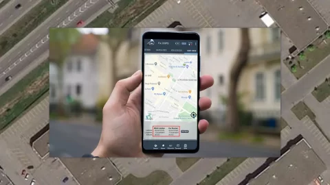
High-accuracy data collection has come a long way since the USA launched the first GNSS constellation, GPS, in the 1970s. Today, all you need to get started with submeter or centimeter data collection is a smart device, a collection app, and a GNSS receiver that works with both.

ArcGIS Collector: How to Configure Collector on Android with Arrow GNSS

ArcGIS Collector - How to configure Collector on Android with Arrow GNSS GPS GIS Esri video iPad mobile mapping

This video walks you through each step of configuring Esri ArcGIS Collector with Arrow Series® GNSS receiver and Eos Tools Pro for Android.

How to Enable Mock Location on Android with Eos Tool Pro

Eos

Enabling mock location on Android lets you use location-aware apps with Arrow GNSS locations. In this article, we’ll show you how to enable mock locations.

Eos Tools Pro: Video Overview for Android App Users

Eos Tools Pro- Video overview for Android app users GPS GNSS GIS alarms RTK

Eos Tools Pro is the free Android app that helps you monitor high-accuracy location in the field. See your DOP, RMS values, PDOP, Differential Status & more.

ArcGIS Collector: Configuring with Arrow GNSS on Android

How to Configure Collector for ArcGIS with Arrow Receivers on Android GIS GPS GNSS Esri

In this article, we show you how to configure ArcGIS Collector with Arrow GNSS receivers on any Android smartphone or tablet.