Knowing how to compute datum offsets is important for shifting between datums. The Eos Tools Pro app now supports computing datum shifts. Here’s how to use it.
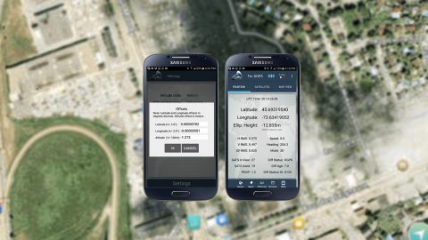
Knowing how to compute datum offsets is important for shifting between datums. The Eos Tools Pro app now supports computing datum shifts. Here’s how to use it.
Wondering how to know if your mobile device GNSS accuracy is correct? This article will break down common issues and how to fix them on iOS or Android.
Learn how to create your ArcGIS organizational account, build & share web maps, collect & edit features and attributes in Collector, and use your Arrow GPS.
In this article we show you how to get high-accuracy locations, including submeter and cm data, with your Arrow GNSS receivers on any iPad or iPhone.
This video walks you through how to use your Arrow GNSS receiver with iOS and the iCMTGIS PRO app. You’ll need your Arrow receiver, iOS device & iCMTGIS PRO.
In this article, we show you how to configure ArcGIS Collector with Arrow GNSS receivers on any Android smartphone or tablet.
One question we get asked is, “How do I know if my iPad/Android is using my Bluetooth GNSS receiver or the internal iPad/Android GNSS receiver?” Here’s how.
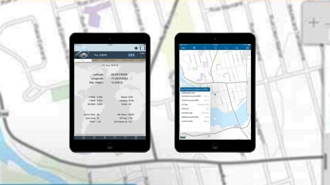
Eos Tools Pro is the free iOS app that helps you monitor high-accuracy location in the field. See your DOP, RMS values, PDOP, and more in real time.
For iOS and Bluetooth™ to be useful together, an accessory (like the high-accuracy Arrow GNSS receiver) and a device (e.g., a tablet) must support in common one of Bluetooth’s standard profiles.
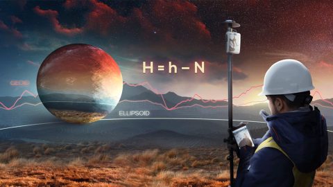
This article shows you how to set up Eos Tools Pro to collect survey-grade orthometric heights in real time with ArcGIS Collector.