Vanessa Pocock uses high-accuracy GNSS and GIS to improve services for residents and visitors in the Resort Municipality of Whistler.

Vanessa Pocock uses high-accuracy GNSS and GIS to improve services for residents and visitors in the Resort Municipality of Whistler.
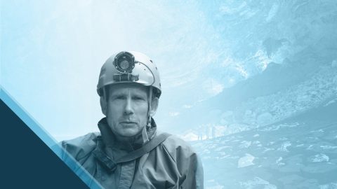
Thomas Shifflett uses high-accuracy GNSS to help locate hidden cave entrances in the dense jungles of Oaxaca, Mexico.

Aaron Krohn prepares his utility for the future by improving field accuracy and efficiency, in part thanks to GNSS.

Ryan Key uses high-accuracy location data to enhance inspections, improve maintenance responses, and increase confidence in utility data.

Learn all about the namesake of the new Skadi Series™ — from the Norse goddess Skadi herself!

Learn how Sarah uses GNSS and GPR to map gravesites at Indigenous Residential Schools with precision and respect.

Dr. Kyle Emery leverages high-accuracy GNSS and drone imagery to deepen our understanding of coastal change.

Discover how Nathan optimizes water services with an efficient mobile data collection workflow!

Charles amps up accuracy for his electric utility clients through easy-to-implement GNSS and GIS solutions.

Hear how David Malm maps city infrastructure with high-accuracy GNSS in this exclusive video interview!